
Ofbyld:West Bank Access Restrictions June 2020.pdf

Oarspronklik bestân (4.964 × 7.020 pixels, bestânsgrutte: 15,18 MB, MIME-type: application/pdf)
Gearfetting
| Beskriuwing |
English: West Bank access restrictions map |
| Datum | |
| Boarne | https://www.ochaopt.org/sites/default/files/westbank_a0_25_06_2020_final.pdf |
| Auteur | United Nations OCHA oPt |
Lisinsje
| This image is a map derived from a United Nations map.
Unless stated otherwise, UN maps are to be considered in the public domain. This applies worldwide. UN maps are, in principle, open source material and you can use them in your work or for making your own map. UN requests however that you delete the UN name, logo and reference number upon any modification to the map. Content of your map will be your responsibility. You can state in your publication, if you wish, something like: based on UN map … (map name, map number, revision number and date). See: Geospatial Information Section. And: Geospatial, location data for a better world. |
 |
Triemskiednis
Klik op in datum/tiid om it bestân te besjen sa't it op dat stuit wie.
| Datum/Tiid | Miniatuer | ôfmjittings | Meidogger | Opmerking | |
|---|---|---|---|---|---|
| lêste | 20 mai 2021, 15.53 | 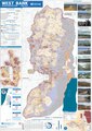 | 4.964 × 7.020 (15,18 MB) | Jul059 | Lossless file size reduction |
| 14 des 2020, 22.33 | Gjin miniatuerôfbylding | 0 × 0 (15,92 MB) | Veggies | Updated for 2020 | |
| 27 jan 2016, 19.32 | Gjin miniatuerôfbylding | 0 × 0 (17,08 MB) | Triggerhippie4 | User created page with UploadWizard |
Bestânsgebrûk
De neikommende side brûkt dit bestân:
Globaal bestânsgebrûk
De neikommende oare wiki's brûke dit bestân:
- Gebrûk op ar.wikipedia.org
- Gebrûk op arz.wikipedia.org
- Gebrûk op azb.wikipedia.org
- Gebrûk op cs.wikipedia.org
- Gebrûk op de.wikipedia.org
- Gebrûk op de.wikivoyage.org
- Gebrûk op el.wikipedia.org
- Gebrûk op en.wikipedia.org
- Israeli settlement
- West Bank
- Population statistics for Israeli settlements in the West Bank
- Israeli checkpoint
- Settler colonialism
- Area C (West Bank)
- User:Falcaorib
- Palestinian enclaves
- Zionism as settler colonialism
- User:Carter McCrae/Israeli–Palestinian conflict
- Israeli incursions in the West Bank during the Israel–Hamas war
- Gebrûk op en.wikivoyage.org
- Gebrûk op eo.wikipedia.org
- Gebrûk op eu.wikipedia.org
- Gebrûk op fa.wikipedia.org
- Gebrûk op fr.wikipedia.org
- Gebrûk op ha.wikipedia.org
- Gebrûk op he.wikipedia.org
- Gebrûk op he.wikiquote.org
- Gebrûk op id.wikipedia.org
- Gebrûk op it.wikivoyage.org
- Gebrûk op ja.wikipedia.org
- Gebrûk op ka.wikipedia.org
- Gebrûk op ko.wikipedia.org
- Gebrûk op nl.wikipedia.org
- Gebrûk op nl.wikinews.org
- Gebrûk op pcm.wikipedia.org
- Gebrûk op pl.wikipedia.org
- Gebrûk op pt.wikipedia.org
- Gebrûk op ru.wikipedia.org
Mear globaal gebrûk fan dit bestân besjen.