
Ofbyld:Former eastern territories of Germany.png
Grutte fan dit proefbyld: 735 × 600 piksels. Oare resolúsjes: 294 × 240 piksels | 588 × 480 piksels | 794 × 648 piksels.
Oarspronklik bestân (794 × 648 pixels, bestânsgrutte: 63 KB, MIME-type: image/png)

|
This map image could be re-created using vector graphics as an SVG file. This has several advantages; see Commons:Media for cleanup for more information. If an SVG form of this image is available, please upload it and afterwards replace this template with
{{vector version available|new image name}}.
It is recommended to name the SVG file “Former eastern territories of Germany.svg”—then the template Vector version available (or Vva) does not need the new image name parameter. |
Gearfetting
| Beskriuwing |
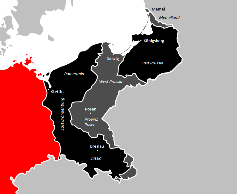
Deutsch: Ehemalige Ostgebiete Deutschlands, Nahaufnahme. Das heutige Deutschland in Rot, nach dem 2. Weltkrieg verlorenes Land in schwarz, nach dem 1. Weltkrieg verlorenes Land in dunkelgrau.
Nach dem Ersten Weltkrieg verlorenes Territorium.
Nach dem Zweiten Weltkrieg verlorenes Territorium.
Das heutige Deutschland. English: Former eastern territories of Germany, close-up. Present-day Germany in red, land lost after WW2 in black, land lost after WW1 in dark gray.
Territory lost after World War I
Territory lost after World War II
Present-day Germany Español: Antiguos territorios orientales de Alemania, primer plano. La Alemania actual en rojo, la tierra perdida después de la Segunda Guerra Mundial en negro, la tierra perdida después de la Primera Guerra Mundial en gris oscuro.
Territorio perdido después de la I Guerra Mundial.
Territorio perdido después de la II Guerra Mundial.
Alemania actualmente. |
| Datum | |
| Boarne | Eigen wurk |
| Auteur | Ernio48 |
Lisinsje
I, the copyright holder of this work, hereby publish it under the following license:
This file is licensed under the Creative Commons Attribution-Share Alike 4.0 International license.
- Fiel jo frij:
- te dielen – it wurk te kopiearjen, fersprieden en út te stjoeren
- te fermingen – it wurk oan te passen
- Under de neikommende betingsten:
- Nammefermelding – You must give appropriate credit, provide a link to the license, and indicate if changes were made. You may do so in any reasonable manner, but not in any way that suggests the licensor endorses you or your use.
- Lyk diele – If you remix, transform, or build upon the material, you must distribute your contributions under the same or compatible license as the original.
Triemskiednis
Klik op in datum/tiid om it bestân te besjen sa't it op dat stuit wie.
| Datum/Tiid | Miniatuer | ôfmjittings | Meidogger | Opmerking | |
|---|---|---|---|---|---|
| lêste | 19 mai 2018, 17.53 | | 794 × 648 (63 KB) | Ernio48 | Major cities, names of regions. |
| 1 mai 2018, 22.07 |  | 794 × 648 (53 KB) | Ernio48 | No Austro-Hungarian/Russian boundary. | |
| 12 feb 2017, 04.10 |  | 794 × 648 (51 KB) | Ernio48 | Making a difference between land lost in WW1 and WW2. | |
| 12 feb 2017, 00.55 |  | 726 × 592 (38 KB) | Ernio48 | User created page with UploadWizard |
Bestânsgebrûk
De neikommende side brûkt dit bestân:
Globaal bestânsgebrûk
De neikommende oare wiki's brûke dit bestân:
- Gebrûk op ar.wikipedia.org
- Gebrûk op cs.wikipedia.org
- Gebrûk op de.wikipedia.org
- Gebrûk op en.wikipedia.org
- Gebrûk op eo.wikipedia.org
- Gebrûk op es.wikipedia.org
- Gebrûk op et.wikipedia.org
- Gebrûk op fi.wikipedia.org
- Gebrûk op he.wikipedia.org
- Gebrûk op ja.wikipedia.org
- Gebrûk op pl.wikipedia.org
- Gebrûk op pt.wikipedia.org
- Gebrûk op simple.wikipedia.org
- Gebrûk op www.wikidata.org
- Gebrûk op zh.wikipedia.org