
Ofbyld:Yazoo river.gif

Grutte fan dit proefbyld: 477 × 599 piksels. Oare resolúsjes: 191 × 240 piksels | 382 × 480 piksels | 776 × 975 piksels.
Oarspronklik bestân (776 × 975 pixels, bestânsgrutte: 46 KB, MIME-type: image/gif)
| Beskriuwing |
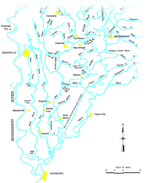
Map of the Yazoo River watershed — located in Mississippi.
|
|||
| Boarne |
http://www.mvk.usace.army.mil/offices/pp/projects/yazoobackwater/docs/01app4.pdf[dead link] |
|||
| Auteur | ||||
| Tastimming (Reusing this file) |
|
Triemskiednis
Klik op in datum/tiid om it bestân te besjen sa't it op dat stuit wie.
| Datum/Tiid | Miniatuer | ôfmjittings | Meidogger | Opmerking | |
|---|---|---|---|---|---|
| lêste | 19 nov 2006, 21.19 | | 776 × 975 (46 KB) | PhilFree | Yazoo River, USA. The image uploaded is modified from the original created by U. S. Army Corps of Engineers' Vicksburg District ([http://www.mvk.usace.army.mil/offices/pp/projects/yazoobackwater/docs/01app4.pdf Yazoo Backwater Reformulation Report (pdf)]) |
Bestânsgebrûk
De neikommende side brûkt dit bestân:
Globaal bestânsgebrûk
De neikommende oare wiki's brûke dit bestân:
- Gebrûk op ar.wikipedia.org
- Gebrûk op cs.wikipedia.org
- Gebrûk op da.wikipedia.org
- Gebrûk op de.wikipedia.org
- Gebrûk op en.wikipedia.org
- Gebrûk op es.wikipedia.org
- Gebrûk op fr.wikipedia.org
- Gebrûk op it.wikipedia.org
- Gebrûk op pl.wikipedia.org
- Gebrûk op sv.wikipedia.org
- Gebrûk op www.wikidata.org