
Ofbyld:WWI.png
Grutte fan dit proefbyld: 800 × 333 piksels. Oare resolúsjes: 320 × 133 piksels | 640 × 266 piksels | 1.502 × 625 piksels.
Oarspronklik bestân (1.502 × 625 pixels, bestânsgrutte: 52 KB, MIME-type: image/png)
Gearfetting
| Beskriuwing |
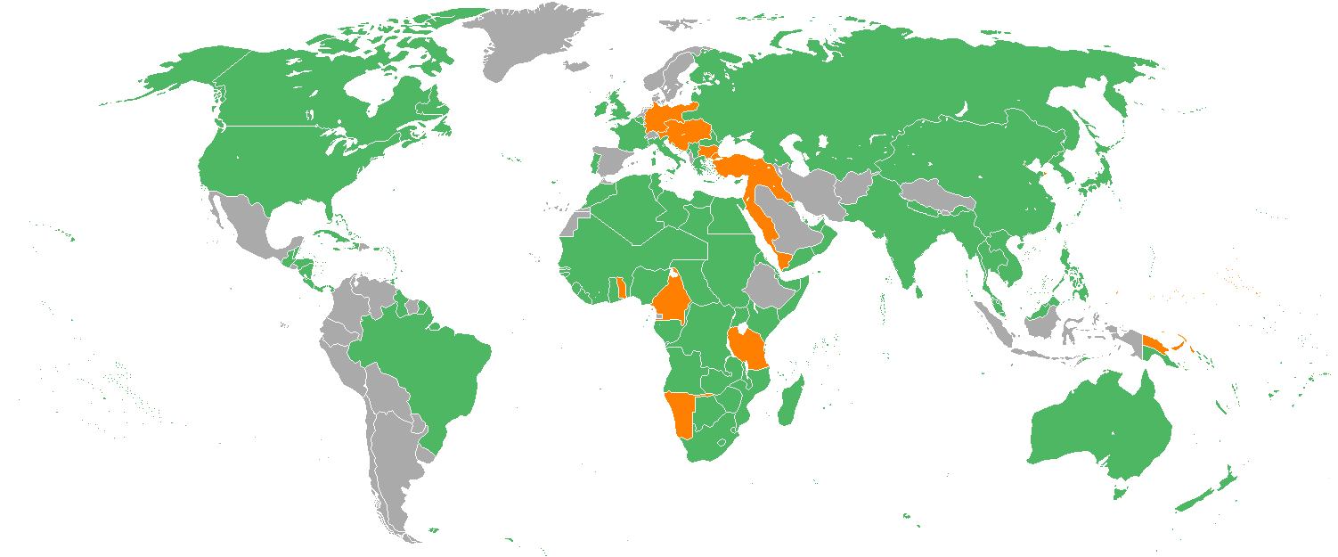
English: Map with the Participants in World War I:
Русский: Карта мира начала XX в. с границами альянсов:
Deutsch: Karte der Beteiligten des Ersten Weltkrieges:
|
| Datum | 22 desimber 2005 (original upload date) |
| Boarne | Transferred from en.wikipedia to Commons. |
| Auteur | Helmandsare, Joaopais, El Jaber, Aivazovsky + Various (Sjoch ûnder.) |
| Oare ferzjes |
|


|
This military map image could be re-created using vector graphics as an SVG file. This has several advantages; see Commons:Media for cleanup for more information. If an SVG form of this image is available, please upload it and afterwards replace this template with
{{vector version available|new image name}}.
It is recommended to name the SVG file “WWI.svg”—then the template Vector version available (or Vva) does not need the new image name parameter. |
Lisinsje
Aivazovsky at the English Wikipedia, the copyright holder of this work, hereby publishes it under the following license:

|
Der wurdt tastimming jûn ta kopiearjen, fersprieden en/of wizigjen fan dit dokumint ûnder de betinksten fan de GNU-lisinsje foar iepen dokumintaasje, ferzje 1.2, as eltse lettere ferzje útjûn troch de Free Software Foundation; sûnder Ynfariante Seksjes, sûnder Omkaftteksten foar de Foarkante en sûnder Omkaftteksten foar de Efterkante. In kopy fan de lisinsje is opnaam yn de seksje "Text of the GNU Free Documentation License". |
| This file is licensed under the Creative Commons Attribution-Share Alike 3.0 Unported license. | ||
| Nammefermelding: Aivazovsky at the English Wikipedia | ||
| ||
| This licensing tag was added to this file as part of the GFDL licensing update. |
Original upload log
The original description page was here. All following user names refer to en.wikipedia.
- 2007-02-14 15:32 Aivazovsky 1357×628×8 (30657 bytes) Fixed northern islands of Russia and Norway, fixed borders of Russia's South Caucasus territory
- 2006-05-02 21:54 Helmandsare 1357×628×8 (30663 bytes)
- 2006-01-19 19:34 Joaopais 1357×628×8 (30415 bytes)
- 2006-01-15 12:12 El Jaber 1357×628×8 (45477 bytes) Map with the [[Participants in World War I]]: * <font color="green">''Green''</font>: [[Allies of World War I|Allies]] * <font color="red">''Red''</font>: [[Central Powers]] * <font color="yellow">''Yellow''</font>: [[Neutral Country|Neutral Countries]]
- 2005-12-22 00:53 Joaopais 1357×628×8 (30366 bytes) added Belize and the Guyanas (at the time British and French colonies)
- 2005-12-22 00:19 Joaopais 1357×628×8 (30365 bytes) Map with the [[Participants in World War I]]: * <font color="green">''Green''</font>: [[Allies of World War I|Allies]] * <font color="orange">''Orange''</font>: [[Axis Powers]]
Triemskiednis
Klik op in datum/tiid om it bestân te besjen sa't it op dat stuit wie.
| Datum/Tiid | Miniatuer | ôfmjittings | Meidogger | Opmerking | |
|---|---|---|---|---|---|
| lêste | 27 feb 2014, 20.19 | | 1.502 × 625 (52 KB) | Grachifan | major update |
| 27 feb 2014, 20.18 |  | 1.502 × 625 (60 KB) | Grachifan | major update | |
| 27 feb 2014, 20.17 |  | 1.502 × 625 (54 KB) | Grachifan | major update | |
| 31 mrt 2013, 05.28 |  | 1.357 × 628 (45 KB) | OgreBot | (BOT): Reverting to most recent version before archival | |
| 31 mrt 2013, 05.28 |  | 1.357 × 628 (30 KB) | OgreBot | (BOT): Uploading old version of file from en.wikipedia; originally uploaded on 2006-05-02 21:54:27 by Helmandsare | |
| 31 mrt 2013, 05.27 |  | 1.357 × 628 (30 KB) | OgreBot | (BOT): Uploading old version of file from en.wikipedia; originally uploaded on 2006-01-19 19:34:32 by Joaopais | |
| 31 mrt 2013, 05.27 |  | 1.357 × 628 (44 KB) | OgreBot | (BOT): Uploading old version of file from en.wikipedia; originally uploaded on 2006-01-15 12:12:07 by El Jaber | |
| 31 mrt 2013, 05.27 |  | 1.357 × 628 (30 KB) | OgreBot | (BOT): Uploading old version of file from en.wikipedia; originally uploaded on 2005-12-22 00:53:03 by Joaopais | |
| 31 mrt 2013, 05.27 |  | 1.357 × 628 (30 KB) | OgreBot | (BOT): Uploading old version of file from en.wikipedia; originally uploaded on 2005-12-22 00:19:12 by Joaopais | |
| 5 jan 2013, 01.42 |  | 1.357 × 628 (45 KB) | Tfts | marked Albania as a neutral state |
Bestânsgebrûk
De neikommende side brûkt dit bestân:
Globaal bestânsgebrûk
De neikommende oare wiki's brûke dit bestân:
- Gebrûk op als.wikipedia.org
- Gebrûk op ar.wikipedia.org
- Gebrûk op az.wikipedia.org
- Gebrûk op be.wikipedia.org
- Gebrûk op bg.wikipedia.org
- Gebrûk op ca.wikipedia.org
- Gebrûk op ceb.wikipedia.org
- Gebrûk op ce.wikipedia.org
- Gebrûk op da.wikipedia.org
- Gebrûk op de.wikipedia.org
- Gebrûk op en.wikipedia.org
- Gebrûk op eo.wikipedia.org
- Gebrûk op es.wikipedia.org
- Gebrûk op eu.wikipedia.org
- Gebrûk op he.wikipedia.org
- Gebrûk op hr.wikipedia.org
- Gebrûk op hsb.wikipedia.org
- Gebrûk op hy.wikipedia.org
- Gebrûk op id.wikipedia.org
- Gebrûk op ja.wikipedia.org
- Gebrûk op kk.wikipedia.org
- Gebrûk op ko.wikipedia.org
- Gebrûk op la.wikipedia.org
- Gebrûk op lld.wikipedia.org
- Gebrûk op ms.wikipedia.org
- Gebrûk op nds.wikipedia.org
- Gebrûk op nl.wikipedia.org
- Gebrûk op pa.wikipedia.org
- Gebrûk op pl.wikipedia.org
- Gebrûk op pt.wikipedia.org
- Gebrûk op ro.wikipedia.org
- Gebrûk op ru.wikipedia.org
- Gebrûk op sh.wikipedia.org
- Gebrûk op si.wikipedia.org
Mear globaal gebrûk fan dit bestân besjen.