
Ofbyld:The route of 'The Martian' - from Chryse Planitia over Arabia Terra in the Martian highlands to Ares 4.jpg

Grutte fan dit proefbyld: 749 × 599 piksels. Oare resolúsjes: 300 × 240 piksels | 600 × 480 piksels | 960 × 768 piksels | 1.280 × 1.024 piksels | 2.082 × 1.666 piksels.
Oarspronklik bestân (2.082 × 1.666 pixels, bestânsgrutte: 2,25 MB, MIME-type: image/jpeg)


Gearfetting
| Beskriuwing |
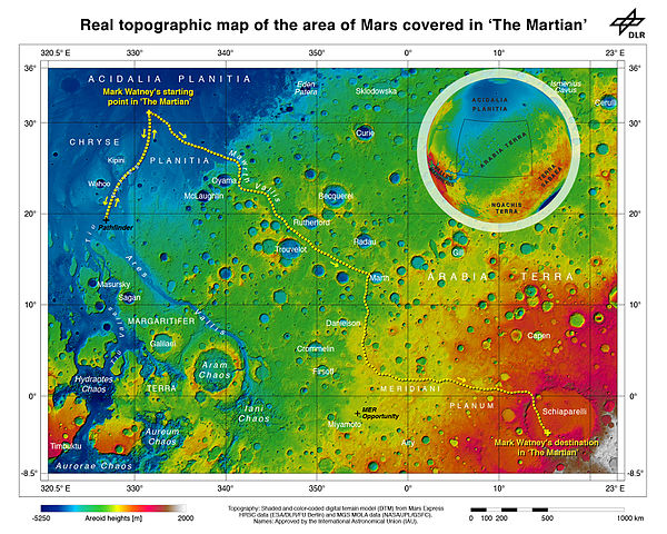
English: As part of the HRSC experiment on board ESA’s Mars Express spacecraft, scientists from the DLR Institute of Planetary Research have mapped the transition zone between the equator and the northern tropic region topographically. On the map, which contains sheet MC11 east, the route that ‘The Martian’, Mark Watney, travelled on Mars has been illustrated. Before he was able to leave his location at Chryse Planitia for the safety of Ares 4 in Schiaparelli Crater, he had to set up a radio transmitter that he obtained at the landing site of the first Mars rover, Soujourner, which arrived on the Red Planet in 1997 as part of the Mars Pathfinder mission. Sojourner was located a few hundred kilometres to the south of Chryse Planitia. His journey continued to the mouth of Mawrth Vallis, which he drove up and gained about 2000 metres in altitude. Following this, Watney drove an additional 2500 metres uphill through the rough Meridiani Planum, which is littered with craters, to the rim of the 450-kilometre diameter Schiaparelli Crater. On the northwestern rim of the crater, a landslide has created a natural ramp that Watney used to access the crater floor, some 700 metres below, where the the Ares-4 rocket was 'parked'. |
||||
| Datum | |||||
| Boarne | https://www.flickr.com/photos/dlr_de/21344671284/ | ||||
| Auteur | ESA/DLR/FU Berlin – CC BY-SA 3.0 IGO | ||||
| Oare ferzjes |
|


Lisinsje
This media was created by the European Space Agency (ESA).
Where expressly so stated, images or videos are covered by the Creative Commons Attribution-ShareAlike 3.0 IGO (CC BY-SA 3.0 IGO) licence, ESA being an Intergovernmental Organisation (IGO), as defined by the CC BY-SA 3.0 IGO licence. The user is allowed under the terms and conditions of the CC BY-SA 3.0 IGO license to Reproduce, Distribute and Publicly Perform the ESA images and videos released under CC BY-SA 3.0 IGO licence and the Adaptations thereof, without further explicit permission being necessary, for as long as the user complies with the conditions and restrictions set forth in the CC BY-SA 3.0 IGO licence, these including that:
See the ESA Creative Commons copyright notice for complete information, and this article for additional details.
|
 | |
This file is licensed under the Creative Commons Attribution-ShareAlike 3.0 IGO license. Nammefermelding: ESA/DLR/FU Berlin, CC BY-SA IGO 3.0
| ||
| This image was originally posted to Flickr. Its license was verified as "cc-by-2.0" by the UploadWizard Extension at the time it was transferred to Commons. See the license information for further details. |
This file is licensed under the Creative Commons Attribution 2.0 Generic license.
Nammefermelding: ESA/DLR/FU Berlin
- Fiel jo frij:
- te dielen – it wurk te kopiearjen, fersprieden en út te stjoeren
- te fermingen – it wurk oan te passen
- Under de neikommende betingsten:
- Nammefermelding – You must give appropriate credit, provide a link to the license, and indicate if changes were made. You may do so in any reasonable manner, but not in any way that suggests the licensor endorses you or your use.
Triemskiednis
Klik op in datum/tiid om it bestân te besjen sa't it op dat stuit wie.
| Datum/Tiid | Miniatuer | ôfmjittings | Meidogger | Opmerking | |
|---|---|---|---|---|---|
| lêste | 7 nov 2015, 06.42 | | 2.082 × 1.666 (2,25 MB) | Huntster | Remove excess whitespace. |
| 7 nov 2015, 06.23 |  | 2.963 × 1.666 (2,36 MB) | Huntster | User created page with UploadWizard |
Bestânsgebrûk
De neikommende side brûkt dit bestân:
Globaal bestânsgebrûk
De neikommende oare wiki's brûke dit bestân:
- Gebrûk op en.wikipedia.org
- Gebrûk op es.wikipedia.org
- Gebrûk op hu.wikipedia.org
- Gebrûk op hy.wikipedia.org
- Gebrûk op ja.wikipedia.org
- Gebrûk op mk.wikipedia.org
- Gebrûk op ms.wikipedia.org
- Gebrûk op pt.wikipedia.org
- Gebrûk op ru.wikipedia.org
- Gebrûk op zh.wikipedia.org