
Ofbyld:Sierra Nevada map.png
Gjin hegere resolúsje beskikber.
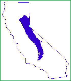
Sierra_Nevada_map.png (278 × 315 pixels, bestânsgrutte: 5 KB, MIME-type: image/png)

|
Ofbyld:Sierra Nevada map vector.svg is in fektorferzje fan dizze triem. As net fan sljochtere kwaliteit tsjinnet dizze brûkt te wurden yn plak fan dizze rasterôfbylding.
File:Sierra Nevada map.png → File:Sierra Nevada map vector.svg
Sjoch Help:SVG foar mear ynformaasje. |
 |
Gearfetting
| Beskriuwing | |
| Datum | |
| Boarne | http://www.fs.fed.us/r5/spf/publications/fh_94-95/m261e.htm |
| Auteur | John W. Dale, U.S. Forest Service |
| Tastimming (Reusing this file) |
Public Domain |
Lisinsje
This image is a work of the Forest Service of the United States Department of Agriculture. As a work of the U.S. federal government, the image is in the public domain.
|
Triemskiednis
Klik op in datum/tiid om it bestân te besjen sa't it op dat stuit wie.
| Datum/Tiid | Miniatuer | ôfmjittings | Meidogger | Opmerking | |
|---|---|---|---|---|---|
| lêste | 8 jan 2007, 01.21 | | 278 × 315 (5 KB) | Hike395 | {{Information |Description=Map of the Sierra Nevada, United States |Source=http://www.fs.fed.us/r5/spf/publications/fh_94-95/m261e.htm |Date=1999-07-12 |Author=John W. Dale, U.S. Forest Service |Permission=Public Domain }} |
Bestânsgebrûk
De neikommende side brûkt dit bestân:
Globaal bestânsgebrûk
De neikommende oare wiki's brûke dit bestân:
- Gebrûk op af.wikipedia.org
- Gebrûk op cs.wikipedia.org
- Gebrûk op cy.wikipedia.org
- Gebrûk op de.wikipedia.org
- Gebrûk op en.wikipedia.org
- Gebrûk op eo.wikipedia.org
- Gebrûk op fi.wiktionary.org
- Gebrûk op frr.wikipedia.org
- Gebrûk op gd.wikipedia.org
- Gebrûk op gl.wikipedia.org
- Gebrûk op he.wikipedia.org
- Gebrûk op hr.wikipedia.org
- Gebrûk op id.wikipedia.org
- Gebrûk op ja.wikipedia.org
- Gebrûk op ko.wikipedia.org
- Gebrûk op ml.wikipedia.org
- Gebrûk op mr.wikipedia.org
- Gebrûk op nn.wikipedia.org
- Gebrûk op no.wikipedia.org
- Gebrûk op pnb.wikipedia.org
- Gebrûk op pt.wikipedia.org
- Gebrûk op sco.wikipedia.org
- Gebrûk op sh.wikipedia.org
- Gebrûk op simple.wikipedia.org
- Gebrûk op sk.wikipedia.org
- Gebrûk op sl.wikipedia.org
- Gebrûk op sr.wikipedia.org
- Gebrûk op sv.wikipedia.org
- Gebrûk op ta.wikipedia.org
- Gebrûk op tr.wikipedia.org
- Gebrûk op uk.wikipedia.org
- Gebrûk op vi.wikipedia.org
- Gebrûk op zh.wikipedia.org