
Ofbyld:SatNordfriesischeInseln.jpg

Grutte fan dit proefbyld: 296 × 600 piksels. Oare resolúsjes: 118 × 240 piksels | 237 × 480 piksels | 379 × 768 piksels | 1.278 × 2.590 piksels.
Oarspronklik bestân (1.278 × 2.590 pixels, bestânsgrutte: 1,63 MB, MIME-type: image/jpeg)
Gearfetting
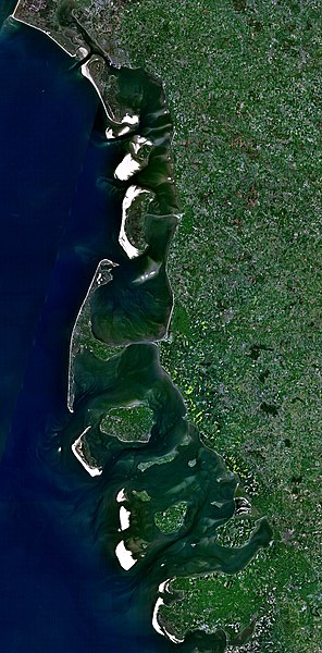
| Beskriuwing |
Deutsch: Satellitenaufnahme der Nordfriesischen Inseln (Dänemark/Deutschland) |
| Datum | 21 desimber 2005 (upload date) |
| Boarne | Satellite imagery taken from NASA World Wind software (by screenshot) |
| Auteur | NASA |
Lisinsje
| This image is in the public domain because it is a screenshot from NASA’s globe software World Wind using a public domain layer, such as Blue Marble, MODIS, Landsat, SRTM, USGS or GLOBE.
|
 |
Triemskiednis
Klik op in datum/tiid om it bestân te besjen sa't it op dat stuit wie.
| Datum/Tiid | Miniatuer | ôfmjittings | Meidogger | Opmerking | |
|---|---|---|---|---|---|
| lêste | 21 des 2005, 20.37 | | 1.278 × 2.590 (1,63 MB) | Godewind | * Satellitenaufnahme Nordfriesischen Inseln (Dänemark/Deutschland) * from Nasa World Wind - Free Satellite Image {{PD-USGov}} Category:Satellite photos Category:Satellite images of the islands |
Bestânsgebrûk
Der binne gjin siden dy't dit bestân brûke.
Globaal bestânsgebrûk
De neikommende oare wiki's brûke dit bestân:
- Gebrûk op br.wikipedia.org
- Gebrûk op cs.wikipedia.org
- Gebrûk op de.wikipedia.org
- Gebrûk op el.wikipedia.org
- Gebrûk op es.wikipedia.org
- Gebrûk op frr.wikipedia.org
- Gebrûk op hu.wikipedia.org
- Gebrûk op pl.wikipedia.org
- Gebrûk op stq.wikipedia.org
- Gebrûk op zh.wikipedia.org