
Ofbyld:Map of Labette Co, Ks, USA.png

Grutte fan dit proefbyld: 523 × 599 piksels. Oare resolúsjes: 209 × 240 piksels | 419 × 480 piksels | 770 × 882 piksels.
Oarspronklik bestân (770 × 882 pixels, bestânsgrutte: 240 KB, MIME-type: image/png)
Gearfetting
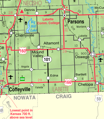
| Beskriuwing | This map of Labette County, Kansas, USA, is copied at a resolution of 300 pixels/inch from the original PDF file. |
| Datum | |
| Boarne | Kansas 2005–2006 Official Transportation Map [1] (map legend) |
| Auteur | Designed and published by the Kansas Department of Transportation. |
| Tastimming (Reusing this file) |
Lisinsje
| This work has been released into the public domain by its author, Kansas Department of Transportation. This applies worldwide. In some countries this may not be legally possible; if so: Kansas Department of Transportation grants anyone the right to use this work for any purpose, without any conditions, unless such conditions are required by law.
|
This map is published by the Kansas Department of Transportation and is distributed to the public free of charge. KDOT makes no warranties, guarantees, or representations for accuracy of this information and assumes no liability for errors or omissions. Maps produced using tax payer dollars are free for public use.
Triemskiednis
Klik op in datum/tiid om it bestân te besjen sa't it op dat stuit wie.
| Datum/Tiid | Miniatuer | ôfmjittings | Meidogger | Opmerking | |
|---|---|---|---|---|---|
| lêste | 27 mrt 2006, 04.19 | | 770 × 882 (240 KB) | Moverton | Source: Kansas 2005-2006 Official Transportation Map {{PD-US}} |
Bestânsgebrûk
De neikommende side brûkt dit bestân:
Globaal bestânsgebrûk
De neikommende oare wiki's brûke dit bestân:
- Gebrûk op azb.wikipedia.org
- Gebrûk op en.wikipedia.org
- Gebrûk op fa.wikipedia.org
- Gebrûk op simple.wikipedia.org
- Gebrûk op ur.wikipedia.org
- Gebrûk op zh.wikipedia.org