
Ofbyld:MapNetherlandsWater.PNG

Grutte fan dit proefbyld: 450 × 599 piksels. Oare resolúsjes: 180 × 240 piksels | 580 × 772 piksels.
Oarspronklik bestân (580 × 772 pixels, bestânsgrutte: 91 KB, MIME-type: image/png)
This image is in the public domain because it came from the site https://www.demis.nl/products/web-map-server/examples/ and was released by the copyright holder. Permission is granted to copy, distribute and/or modify this map since it is based on free of copyright images from: www.demis.nl. See also approval email on de.wp and its clarification.
|
| This work has been released into the public domain by its copyright holder, www.demis.nl. This applies worldwide. In some countries this may not be legally possible; if so: www.demis.nl grants anyone the right to use this work for any purpose, without any conditions, unless such conditions are required by law.
|
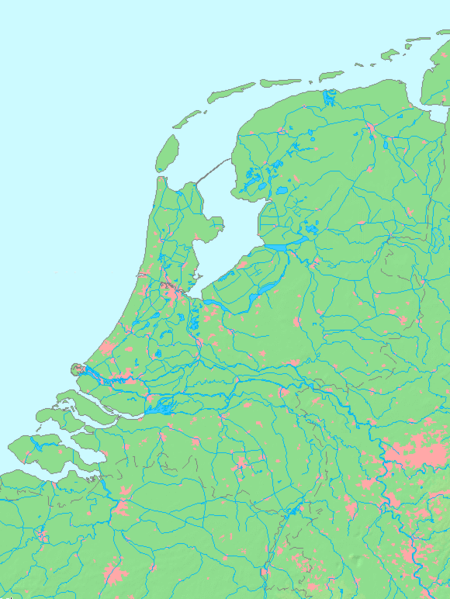
- map shows waterbodies , rivers and canals in Netherlands
derivative works
Derivative works of this file:
Triemskiednis
Klik op in datum/tiid om it bestân te besjen sa't it op dat stuit wie.
| Datum/Tiid | Miniatuer | ôfmjittings | Meidogger | Opmerking | |
|---|---|---|---|---|---|
| lêste | 14 okt 2015, 15.00 | | 580 × 772 (91 KB) | Io Herodotus | Afsluitdijk |
| 16 okt 2005, 17.12 |  | 580 × 772 (77 KB) | Michiel1972 | cor. | |
| 16 okt 2005, 15.35 |  | 580 × 772 (77 KB) | Michiel1972 | *map shows waterbodies , rivers and canals in Netherlands *based on free-licence data/map software http://www.demis.nl/home category:Maps of the Netherlands |
Bestânsgebrûk
Der binne gjin siden dy't dit bestân brûke.
Globaal bestânsgebrûk
De neikommende oare wiki's brûke dit bestân:
- Gebrûk op br.wikipedia.org
- Gebrûk op en.wikipedia.org
- Gebrûk op fr.wikipedia.org
- Gebrûk op nl.wikipedia.org
- Gebrûk op ro.wikipedia.org