
Ofbyld:Locator Electoral Palatinate within the Holy Roman Empire (1618).svg

Size of this PNG preview of this SVG file: 658 × 600 piksels. Oare resolúsjes: 263 × 240 piksels | 527 × 480 piksels | 843 × 768 piksels | 1.123 × 1.024 piksels | 2.247 × 2.048 piksels | 2.769 × 2.524 piksels.
Oarspronklik bestân (SVG-bestân, nominaal 2.769 × 2.524 pixels, bestânsgrutte: 1 MB)
.svg)
Gearfetting
| Beskriuwing |
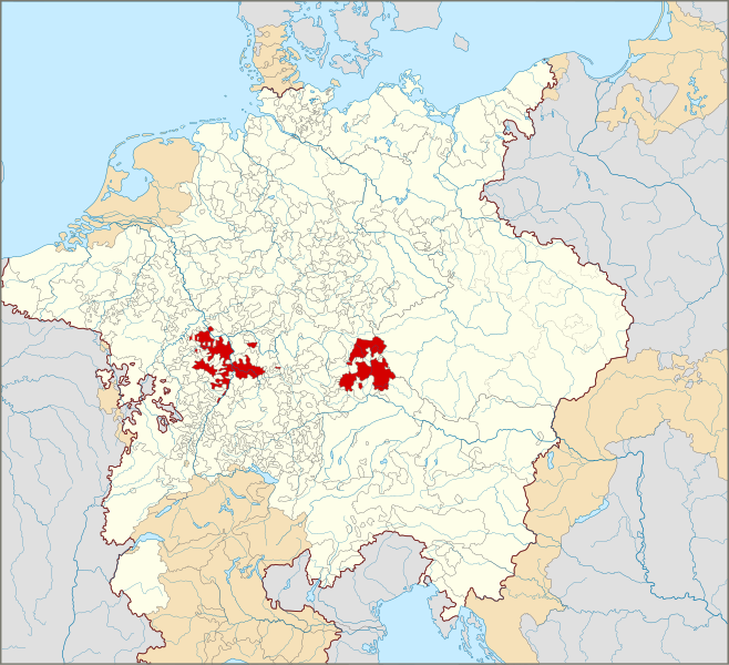
English: Locator Map of the Electoral Palatinate within the Holy Roman Empire (1618)
The Electoral Palatinate in 1618.
Territories of the Holy Roman Empire.
Territories connected with the Holy Roman Empire, including the Imperial Italy, the Swiss Confederacy, Barrois mouvant, Sedan, Lauenburg and Bütow, Ducal Prussia, the Duchy of Schleswig and the Dutch Republic.
Territories outside the Holy Roman Empire.
Nederlands: Locatiekaart van de Keur-Palts binnen het Heilige Roomse Rijk (1618) |
| Datum | |
| Boarne |
|
| Auteur |
This W3C-unspecified vector image was created with Inkscape . |
Lisinsje
I, the copyright holder of this work, hereby publish it under the following license:
This file is licensed under the Creative Commons Attribution-Share Alike 4.0 International license.
- Fiel jo frij:
- te dielen – it wurk te kopiearjen, fersprieden en út te stjoeren
- te fermingen – it wurk oan te passen
- Under de neikommende betingsten:
- Nammefermelding – You must give appropriate credit, provide a link to the license, and indicate if changes were made. You may do so in any reasonable manner, but not in any way that suggests the licensor endorses you or your use.
- Lyk diele – If you remix, transform, or build upon the material, you must distribute your contributions under the same or compatible license as the original.
Triemskiednis
Klik op in datum/tiid om it bestân te besjen sa't it op dat stuit wie.
| Datum/Tiid | Miniatuer | ôfmjittings | Meidogger | Opmerking | |
|---|---|---|---|---|---|
| lêste | 28 jan 2015, 02.55 | | 2.769 × 2.524 (1 MB) | Sir Iain | Corrected Bohemian border |
| 27 jan 2015, 16.24 |  | 2.769 × 2.524 (1.018 KB) | Sir Iain | Corrected mistake in Bohemia | |
| 22 jan 2015, 16.19 |  | 2.769 × 2.524 (1.022 KB) | Sir Iain | Redone Schleswig-Holstein | |
| 5 jan 2015, 02.53 |  | 2.769 × 2.524 (998 KB) | Sir Iain | Savoy shown as core territory of the HRR | |
| 23 des 2014, 22.27 |  | 2.769 × 2.524 (998 KB) | Sir Iain | Removed the Imperial border between Germany and the Netherlands | |
| 23 des 2014, 03.18 |  | 2.769 × 2.524 (1.002 KB) | Sir Iain | User created page with UploadWizard |
Bestânsgebrûk
De neikommende side brûkt dit bestân:
Globaal bestânsgebrûk
De neikommende oare wiki's brûke dit bestân:
- Gebrûk op af.wikipedia.org
- Gebrûk op ar.wikipedia.org
- Gebrûk op ast.wikipedia.org
- Gebrûk op az.wikipedia.org
- Gebrûk op bg.wikipedia.org
- Gebrûk op cs.wikipedia.org
- Gebrûk op en.wikipedia.org
- Gebrûk op fa.wikipedia.org
- Gebrûk op fr.wikipedia.org
- Gebrûk op it.wikipedia.org
- Gebrûk op ko.wikipedia.org
- Gebrûk op nl.wikipedia.org
- Gebrûk op ru.wikipedia.org
- Gebrûk op simple.wikipedia.org
- Gebrûk op sr.wikipedia.org
- Gebrûk op uk.wikipedia.org
- Gebrûk op www.wikidata.org
.svg)