
Ofbyld:LocationHungary.png
Gjin hegere resolúsje beskikber.
LocationHungary.png (250 × 115 pixels, bestânsgrutte: 6 KB, MIME-type: image/png)
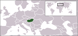
Location map of Hungary.
Originally created for English Wikipedia by Vardion.
| |
This work has been released into the public domain by its author, Vardion, at the Ingelsk Wikipedy project. This applies worldwide. In case this is not legally possible: |

|
Ofbyld:LocationHungary.svg is in fektorferzje fan dizze triem. As net fan sljochtere kwaliteit tsjinnet dizze brûkt te wurden yn plak fan dizze rasterôfbylding.
File:LocationHungary.png → File:LocationHungary.svg
Sjoch Help:SVG foar mear ynformaasje. |
 |
es:Imagen:LocationHungary.png et:Pilt:LocationHungary.png he:תמונה:LocationHungary.png it:Immagine:LocationHungary.png ja:画像:LocationHungary.png
Triemskiednis
Klik op in datum/tiid om it bestân te besjen sa't it op dat stuit wie.
| Datum/Tiid | Miniatuer | ôfmjittings | Meidogger | Opmerking | |
|---|---|---|---|---|---|
| lêste | 6 jun 2006, 18.24 | | 250 × 115 (6 KB) | Rain74 | |
| 6 jun 2006, 18.23 |  | 250 × 115 (6 KB) | Rain74 | Montenegro | |
| 8 des 2004, 15.55 |  | 250 × 115 (7 KB) | EugeneZelenko | Location map for the Hungary.<br/>Originally created for English Wikipedia by Vardion.<br/>{{PD}}<br/>Category:Country locator maps |
Bestânsgebrûk
Der binne gjin siden dy't dit bestân brûke.
Globaal bestânsgebrûk
De neikommende oare wiki's brûke dit bestân:
- Gebrûk op ar.wikinews.org
- Gebrûk op av.wikipedia.org
- Gebrûk op awa.wikipedia.org
- Gebrûk op be-tarask.wikipedia.org
- Gebrûk op bg.wikipedia.org
- Gebrûk op bo.wikipedia.org
- Gebrûk op br.wikipedia.org
- Gebrûk op bs.wikiquote.org
- Gebrûk op ca.wikipedia.org
- Gebrûk op de.wikinews.org
- Gebrûk op de.wiktionary.org
- Gebrûk op el.wikipedia.org
- Gebrûk op el.wiktionary.org
- Gebrûk op en.wikipedia.org
- Gebrûk op en.wikivoyage.org
- Gebrûk op en.wiktionary.org
- Gebrûk op es.wiktionary.org
- Gebrûk op eu.wiktionary.org
- Gebrûk op fiu-vro.wikipedia.org
- Gebrûk op fr.wiktionary.org
- Gebrûk op he.wikivoyage.org
- Gebrûk op hi.wikipedia.org
- Gebrûk op hu.wikinews.org
- Gyöngyösön nem lesz gumiabroncsgyár
- Meghalt Major László
- Stabilizálódott Törőcsik Mari állapota
- Csökkenő mezőgazdasági eredmény
- Gyilkolás Tatárszentgyörgyön
- Sablon:Magyarország
- Nem lehet cigarettázni Szegeden
- Az OSZK új rekordot döntött
- Elhunyt Bacsó Péter
- Egy hónap múlva lesznek a filmnapok
- Holnap kezdődik a BTF
- Megemelkedett az üzemanyag ára
- Csúnyán megsérült Alföldi Róbert
- Újra érme lesz a 200 forintos
- Emelkedik, majd csökken a gáz ára
Mear globaal gebrûk fan dit bestân besjen.