
Ofbyld:Hispania 3a division provincial.PNG
Hispania_3a_division_provincial.PNG (506 × 357 pixels, bestânsgrutte: 10 KB, MIME-type: image/png)

|
This locator map image could be re-created using vector graphics as an SVG file. This has several advantages; see Commons:Media for cleanup for more information. If an SVG form of this image is available, please upload it and afterwards replace this template with
{{vector version available|new image name}}.
It is recommended to name the SVG file “Hispania 3a division provincial.svg”—then the template Vector version available (or Vva) does not need the new image name parameter. |
Gearfetting
| Beskriuwing |
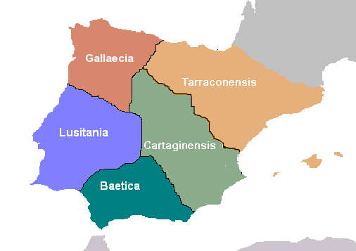
Español: Hispania: División provincial de Diocleciano.
Deutsch: Hispania: Einteilung der Provinzen unter Diocletian. |
| Datum | |
| Boarne | Eigen wurk |
| Auteur | Hispa |
Lisinsje

|
This work is free software; you can redistribute it and/or modify it under the terms of the GNU General Public License as published by the Free Software Foundation; either version 2 of the License, or any later version. This work is distributed in the hope that it will be useful, but without any warranty; without even the implied warranty of merchantability or fitness for a particular purpose. See version 2 and version 3 of the GNU General Public License for more details. |
Triemskiednis
Klik op in datum/tiid om it bestân te besjen sa't it op dat stuit wie.
| Datum/Tiid | Miniatuer | ôfmjittings | Meidogger | Opmerking | |
|---|---|---|---|---|---|
| lêste | 19 jun 2006, 08.17 | | 506 × 357 (10 KB) | Hispa | Repainted version of Hispania's Diocletian division, with better defined frontiers for Cartaginensis province. |
| 15 mai 2006, 18.35 |  | 506 × 357 (13 KB) | Rodriguillo | Bueno... esta creo que ya es la buena | |
| 15 mai 2006, 14.32 |  | 511 × 357 (10 KB) | Rodriguillo | ||
| 15 mai 2006, 14.25 |  | 511 × 357 (13 KB) | Rodriguillo | Revisión hecha por Rodriguillo: las islas Baleares, tras la división de Diocleciano, pertenecían a la Cartaginense | |
| 15 mai 2006, 14.24 |  | 511 × 357 (13 KB) | Rodriguillo | Revisión hecha por Rodriguillo: las islas Baleares, tras la división de Diocleciano, pertenecían a la Cartaginense. | |
| 11 des 2005, 15.32 |  | 511 × 357 (10 KB) | Hispa | Better defined provincial borders | |
| 30 okt 2005, 00.10 |  | 511 × 358 (11 KB) | Hispa | ||
| 29 okt 2005, 22.07 |  | 512 × 421 (14 KB) | Hispa | División provincial de Diocleciano, creado por Hispa Category:Historical maps Category:Maps of Spain |
Bestânsgebrûk
Der binne gjin siden dy't dit bestân brûke.
Globaal bestânsgebrûk
De neikommende oare wiki's brûke dit bestân:
- Gebrûk op an.wikipedia.org
- Gebrûk op ast.wiktionary.org
- Gebrûk op ca.wikipedia.org
- Gebrûk op da.wikipedia.org
- Gebrûk op de.wikipedia.org
- Gebrûk op de.wikibooks.org
- Gebrûk op es.wikipedia.org
- Gebrûk op eu.wikipedia.org
- Gebrûk op fa.wikipedia.org
- Gebrûk op fr.wikipedia.org
- Gebrûk op gl.wikipedia.org
- Gebrûk op he.wikipedia.org
- Gebrûk op it.wikipedia.org
- Gebrûk op mk.wikipedia.org
- Gebrûk op nl.wikipedia.org
- Gebrûk op no.wikipedia.org
- Gebrûk op oc.wikipedia.org
- Gebrûk op sh.wikipedia.org
- Gebrûk op sr.wikipedia.org
Mear globaal gebrûk fan dit bestân besjen.