
Ofbyld:Hawaii population map.png
Gjin hegere resolúsje beskikber.
Hawaii_population_map.png (600 × 600 pixels, bestânsgrutte: 52 KB, MIME-type: image/png)
Gearfetting
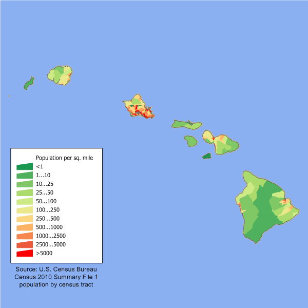
| Beskriuwing |
English: en:Category:U.S. State Population Maps
Hawaii state population density map based on Census 2010 data. See the data lineage for a process description. |
| Datum | 9 maart 2006 (original upload date) |
| Boarne | Transferred from en.wikipedia to Commons. |
| Auteur | JimIrwin at Ingelsk Wikipedy |

|
This map image could be re-created using vector graphics as an SVG file. This has several advantages; see Commons:Media for cleanup for more information. If an SVG form of this image is available, please upload it and afterwards replace this template with
{{vector version available|new image name}}.
It is recommended to name the SVG file “Hawaii population map.svg”—then the template Vector version available (or Vva) does not need the new image name parameter. |
Lisinsje
JimIrwin at the English Wikipedia, the copyright holder of this work, hereby publishes it under the following license:

|
Der wurdt tastimming jûn ta kopiearjen, fersprieden en/of wizigjen fan dit dokumint ûnder de betinksten fan de GNU-lisinsje foar iepen dokumintaasje, ferzje 1.2, as eltse lettere ferzje útjûn troch de Free Software Foundation; sûnder Ynfariante Seksjes, sûnder Omkaftteksten foar de Foarkante en sûnder Omkaftteksten foar de Efterkante. In kopy fan de lisinsje is opnaam yn de seksje "Text of the GNU Free Documentation License". |
| This file is licensed under the Creative Commons Attribution-Share Alike 3.0 Unported license. | ||
| Nammefermelding: JimIrwin at the English Wikipedia | ||
| ||
| This licensing tag was added to this file as part of the GFDL licensing update. |
Original upload log
The original description page was here. All following user names refer to en.wikipedia.
- 2006-03-09 21:48 JimIrwin 660×480×8 (12904 bytes) Hawaii state population density map based on Census 2000 data. See the [[User:JimIrwin/Lineage_of_population_maps|data lineage]] for a process description.
Triemskiednis
Klik op in datum/tiid om it bestân te besjen sa't it op dat stuit wie.
| Datum/Tiid | Miniatuer | ôfmjittings | Meidogger | Opmerking | |
|---|---|---|---|---|---|
| lêste | 11 des 2011, 16.03 | | 600 × 600 (52 KB) | JimIrwin | 2010 census update |
| 29 mai 2008, 03.04 |  | 660 × 480 (13 KB) | Viriditas | {{Information |Description={{en|en:Category:U.S. State Population Maps en:Category:Hawaii maps == Summary == Hawaii state population density map based on Census 2000 data. See the data lineage fo | |
| 12 mai 2008, 21.39 |  | 660 × 480 (13 KB) | File Upload Bot (Magnus Manske) | {{BotMoveToCommons|en.wikipedia}} {{Information |Description={{en|en:Category:U.S. State Population Maps en:Category:Hawaii maps Hawaii state population density map based on Census 2000 data. See the [[:en:User:JimIrwin/Lineage_of_population_ |
Bestânsgebrûk
De neikommende side brûkt dit bestân:
Globaal bestânsgebrûk
De neikommende oare wiki's brûke dit bestân:
- Gebrûk op cy.wikipedia.org
- Gebrûk op de.wikipedia.org
- Gebrûk op el.wikipedia.org
- Gebrûk op en.wikipedia.org
- Gebrûk op es.wikipedia.org
- Gebrûk op fr.wikipedia.org
- Gebrûk op he.wikipedia.org
- Gebrûk op ja.wikipedia.org
- Gebrûk op kn.wikipedia.org
- Gebrûk op ml.wikipedia.org
- Gebrûk op no.wikipedia.org
- Gebrûk op pl.wikipedia.org
- Gebrûk op ro.wikipedia.org
- Gebrûk op ru.wikibooks.org
- Gebrûk op ru.wikivoyage.org