
Ofbyld:ElectoralCollege2016.svg

Oarspronklik bestân (SVG-bestân, nominaal 1.020 × 593 pixels, bestânsgrutte: 30 KB)
| U.S. presidential election maps (SVG) |
| See also: National Atlas maps (png) |
|
1789 · 1792 · 1796 · 1800 · 1804 · 1808 · 1812 · 1816 · 1820 · 1824 · 1828 · 1832 · 1836 · 1840 · 1844 · 1848 · 1852 · 1856 · 1860 · 1864 · 1868 · 1872 · 1876 · 1880 · 1884 · 1888 · 1892 · 1896 · 1900 · 1904 · 1908 · 1912 · 1916 · 1920 · 1924 · 1928 · 1932 · 1936 · 1940 · 1944 · 1948 · 1952 · 1956 · 1960 · 1964 · 1968 · 1972 · 1976 · 1980 · 1984 · 1988 · 1992 · 1996 · 2000 · 2004 · 2008 · 2012 · 2016 · 2020 · 2024 |
Gearfetting
| Beskriuwing |
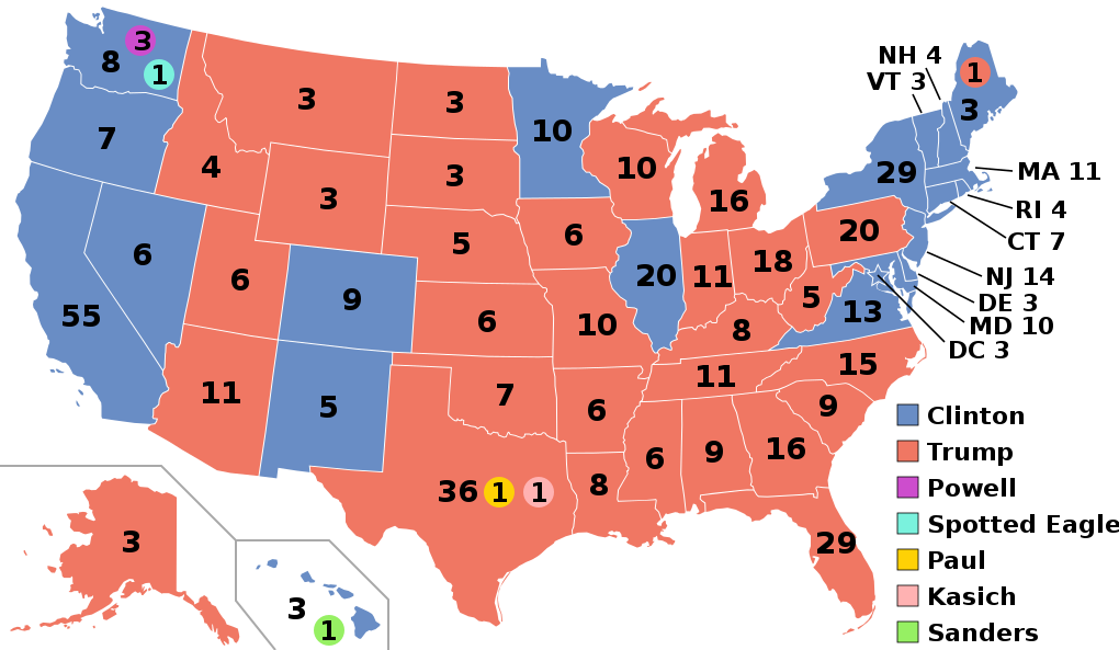
English: Electoral college map for the 2016 United States presidential election (note: Nebraska and Maine split their EVs by congressional district). |
||||
| Datum | |||||
| Boarne | 2012 Electoral College map | ||||
| Auteur | Gage | ||||
| Oare ferzjes |
|
||||
| SVG genesis |

.svg)


.svg)
.svg)


Lisinsje
- Fiel jo frij:
- te dielen – it wurk te kopiearjen, fersprieden en út te stjoeren
- te fermingen – it wurk oan te passen
- Under de neikommende betingsten:
- Nammefermelding – You must give appropriate credit, provide a link to the license, and indicate if changes were made. You may do so in any reasonable manner, but not in any way that suggests the licensor endorses you or your use.
- Lyk diele – If you remix, transform, or build upon the material, you must distribute your contributions under the same or compatible license as the original.
Triemskiednis
Klik op in datum/tiid om it bestân te besjen sa't it op dat stuit wie.
| Datum/Tiid | Miniatuer | ôfmjittings | Meidogger | Opmerking | |
|---|---|---|---|---|---|
| lêste | 27 nov 2020, 05.22 | | 1.020 × 593 (30 KB) | Politicsfan4 | Updated placement of ME-2's electoral vote for consistency with 2020 map |
| 5 aug 2020, 03.22 |  | 1.020 × 593 (30 KB) | Nojus R | Reverted to version as of 07:42, 13 January 2019 (UTC) it looks so weird when every other map uses a different font | |
| 10 des 2019, 21.31 |  | 1.020 × 593 (30 KB) | IagoQnsi | switching font to Arial, as it looks less-ugly in the server-side rendering // Editing SVG source code using c:User:Rillke/SVGedit.js | |
| 13 jan 2019, 09.42 |  | 1.020 × 593 (30 KB) | Newfraferz87 | (minor) | |
| 20 nov 2018, 04.50 |  | 1.020 × 593 (30 KB) | Newfraferz87 | *DC | |
| 20 nov 2018, 04.35 |  | 1.020 × 593 (30 KB) | Newfraferz87 | Simplify further: coordinates & fills, following this | |
| 18 jan 2017, 16.16 |  | 1.020 × 593 (36 KB) | Newfraferz87 | Shrink size using relative line coordinates. Thanks for the border corrections. | |
| 17 jan 2017, 11.20 |  | 1.020 × 593 (43 KB) | Karlfk | Better borderlines, esp. OH/WV/PA triangle or ID/MT border | |
| 12 jan 2017, 05.14 |  | 1.020 × 593 (36 KB) | PalmerTheGolfer | Reverted to version as of 00:56, 3 January 2017 (UTC) Font of numbers and State line consistency with prior elections more important than a non-existent Libretarian faithless elector change | |
| 11 jan 2017, 00.50 |  | 1.020 × 593 (36 KB) | Maproom | Changed font to Liberation Sans, in the hope of avoiding the problem of "Eagle" extending off the end of the image |
.svg)
Bestânsgebrûk
De neikommende side brûkt dit bestân:
Globaal bestânsgebrûk
De neikommende oare wiki's brûke dit bestân:
- Gebrûk op af.wikipedia.org
- Gebrûk op ang.wikipedia.org
- Gebrûk op ar.wikipedia.org
- Gebrûk op arz.wikipedia.org
- Gebrûk op be.wikipedia.org
- Gebrûk op bg.wikipedia.org
- Gebrûk op bn.wikipedia.org
- Gebrûk op bs.wikipedia.org
- Gebrûk op ca.wikipedia.org
- Gebrûk op cdo.wikipedia.org
- Gebrûk op cs.wikipedia.org
- Gebrûk op cy.wikipedia.org
- Gebrûk op da.wikipedia.org
- Gebrûk op de.wikipedia.org
- Gebrûk op dty.wikipedia.org
- Gebrûk op el.wikipedia.org
- Gebrûk op en.wikipedia.org
- Donald Trump
- Electoral vote changes between United States presidential elections
- List of United States presidential election results by state
- Presidency of Barack Obama
- 2016 United States presidential election
- United States presidential election
- 2016 Democratic Party presidential candidates
- 2016 Democratic Party presidential primaries
- 2016 Republican Party presidential candidates
- 2016 Republican Party presidential primaries
- Third party and independent candidates for the 2016 United States presidential election
- 2016 United States elections
- User:ArcMachaon/sandbox
- User:Mandruss/sandbox
- User:Visigoethe/sandbox
- User:Machinekng/sandbox
Mear globaal gebrûk fan dit bestân besjen.