
Ofbyld:Dorset UK locator map 2010.svg

Size of this PNG preview of this SVG file: 494 × 600 piksels. Oare resolúsjes: 198 × 240 piksels | 395 × 480 piksels | 633 × 768 piksels | 843 × 1.024 piksels | 1.687 × 2.048 piksels | 1.108 × 1.345 piksels.
Oarspronklik bestân (SVG-bestân, nominaal 1.108 × 1.345 pixels, bestânsgrutte: 302 KB)
Gearfetting
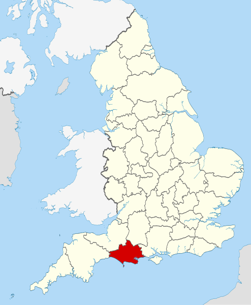
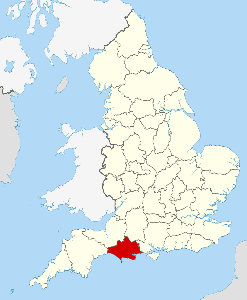
| Beskriuwing | Location of the ceremonial county of Dorset within England. |
| Datum | |
| Boarne |
National Geospatial-Intelligence Agency
|
| Auteur | Nilfanion |
Lisinsje
I, the copyright holder of this work, hereby publish it under the following licenses:
This file is licensed under the Creative Commons Attribution-Share Alike 3.0 Unported license.
- Fiel jo frij:
- te dielen – it wurk te kopiearjen, fersprieden en út te stjoeren
- te fermingen – it wurk oan te passen
- Under de neikommende betingsten:
- Nammefermelding – You must give appropriate credit, provide a link to the license, and indicate if changes were made. You may do so in any reasonable manner, but not in any way that suggests the licensor endorses you or your use.
- Lyk diele – If you remix, transform, or build upon the material, you must distribute your contributions under the same or compatible license as the original.

|
Der wurdt tastimming jûn ta kopiearjen, fersprieden en/of wizigjen fan dit dokumint ûnder de betinksten fan de GNU-lisinsje foar iepen dokumintaasje, ferzje 1.2, as eltse lettere ferzje útjûn troch de Free Software Foundation; sûnder Ynfariante Seksjes, sûnder Omkaftteksten foar de Foarkante en sûnder Omkaftteksten foar de Efterkante. In kopy fan de lisinsje is opnaam yn de seksje "Text of the GNU Free Documentation License". |
You may select the license of your choice.

|
This is one of the images forming part of the Valued image set: Locator maps of the Ceremonial counties of England on Wikimedia Commons. The image set has been assessed under the valued image set criteria and is considered the most valued set on Commons within the scope:
Locator maps of the Ceremonial counties of England
You can see its nomination at Commons:Valued image candidates/Locator maps of English ceremonial counties. |
Triemskiednis
Klik op in datum/tiid om it bestân te besjen sa't it op dat stuit wie.
| Datum/Tiid | Miniatuer | ôfmjittings | Meidogger | Opmerking | |
|---|---|---|---|---|---|
| lêste | 24 nov 2010, 00.34 | | 1.108 × 1.345 (302 KB) | Nilfanion | == Summary == {{Information |Description=Location of the ceremonial county of Dorset within England. |Source=Ordnance Survey [https://www.ordnancesurvey.co.uk/opendatadownload/products.html OpenData]: *County boundaries |
Bestânsgebrûk
De neikommende side brûkt dit bestân:
Globaal bestânsgebrûk
De neikommende oare wiki's brûke dit bestân:
- Gebrûk op af.wikipedia.org
- Gebrûk op an.wikipedia.org
- Gebrûk op ar.wikipedia.org
- Gebrûk op ast.wikipedia.org
- Gebrûk op be-tarask.wikipedia.org
- Gebrûk op be.wikipedia.org
- Gebrûk op bg.wikipedia.org
- Gebrûk op bn.wikipedia.org
- Gebrûk op ca.wikipedia.org
- Gebrûk op ceb.wikipedia.org
- Gebrûk op cs.wikipedia.org
- Gebrûk op cy.wikipedia.org
- Gebrûk op da.wikipedia.org
- Gebrûk op en.wikipedia.org
- Dorset
- St Ives, Dorset
- Tolpuddle
- Lulworth
- Lytchett Minster
- River Piddle
- Corscombe
- Ballard Down
- West Orchard
- East Orchard
- Radipole Lake
- Hilton, Dorset
- Maiden Newton
- Melbury Abbas
- Purse Caundle
- Stour Provost
- Stourton Caundle
- Sturminster Marshall
- Alderholt
- Beer Hackett
- Bettiscombe
- Bincombe
- Bloxworth
- Bothenhampton
- Bradford Abbas
- Bradford Peverell
- Bradpole
- Broadmayne
- Broadwey
- Broadwindsor
- Bryanston
- Buckhorn Weston
- Burstock
Mear globaal gebrûk fan dit bestân besjen.