
Ofbyld:Crete topographic map-fr.svg

Size of this PNG preview of this SVG file: 800 × 380 piksels. Oare resolúsjes: 320 × 152 piksels | 640 × 304 piksels | 1.024 × 486 piksels | 1.280 × 608 piksels | 2.560 × 1.215 piksels | 3.370 × 1.600 piksels.
Oarspronklik bestân (SVG-bestân, nominaal 3.370 × 1.600 pixels, bestânsgrutte: 2,6 MB)
Gearfetting
| Camera location | | View this and other nearby images on: OpenStreetMap |
|---|
| Beskriuwing |
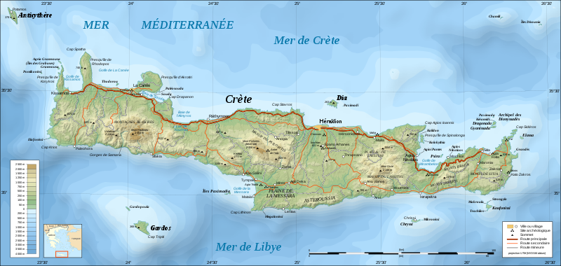
UTM projection; WGS84 datum; shaded relief (composite image of N-W, W and N lightning positions)
|
||
| Datum | |||
| Boarne |
Own work;
|
||
| Auteur | Eric Gaba (Sting - fr:Sting) | ||
| Tastimming (Reusing this file) |
|
||
| Oare ferzjes |
Derivative works of this file: Crete location map.svg
[]
|


|
This SVG file contains embedded text that can be translated into your language, using any capable SVG editor, text editor or the SVG Translate tool. For more information see: About translating SVG files. |
Lisinsje
I, the copyright holder of this work, hereby publish it under the following licenses:

|
Der wurdt tastimming jûn ta kopiearjen, fersprieden en/of wizigjen fan dit dokumint ûnder de betinksten fan de GNU-lisinsje foar iepen dokumintaasje, ferzje 1.2, as eltse lettere ferzje útjûn troch de Free Software Foundation; sûnder Ynfariante Seksjes, sûnder Omkaftteksten foar de Foarkante en sûnder Omkaftteksten foar de Efterkante. In kopy fan de lisinsje is opnaam yn de seksje "Text of the GNU Free Documentation License". |
This file is licensed under the Creative Commons Attribution-Share Alike 4.0 International, 3.0 Unported, 2.5 Generic, 2.0 Generic and 1.0 Generic license.
- Fiel jo frij:
- te dielen – it wurk te kopiearjen, fersprieden en út te stjoeren
- te fermingen – it wurk oan te passen
- Under de neikommende betingsten:
- Nammefermelding – You must give appropriate credit, provide a link to the license, and indicate if changes were made. You may do so in any reasonable manner, but not in any way that suggests the licensor endorses you or your use.
- Lyk diele – If you remix, transform, or build upon the material, you must distribute your contributions under the same or compatible license as the original.
You may select the license of your choice.
Triemskiednis
Klik op in datum/tiid om it bestân te besjen sa't it op dat stuit wie.
| Datum/Tiid | Miniatuer | ôfmjittings | Meidogger | Opmerking | |
|---|---|---|---|---|---|
| lêste | 17 jun 2008, 21.30 | | 3.370 × 1.600 (2,6 MB) | Sting | Colors of bathymetry changed ; other modifications |
| 4 des 2007, 00.38 |  | 3.370 × 1.600 (2,11 MB) | Sting | 2 archaeological sites added | |
| 2 des 2007, 16.08 |  | 3.370 × 1.600 (2,11 MB) | Sting | Slight text rendering improvements | |
| 1 des 2007, 23.09 |  | 3.370 × 1.600 (2,11 MB) | Sting | {{Information |Description=Topographic map in French of Crete island, Greece |Source=Own work ;<br/>Topography : [http://www2.jpl.nasa.gov/srtm NASA Shuttle Radar Topography Mission] (SRTM3 v.2) data (public domain) edited wit |
Bestânsgebrûk
Der binne gjin siden dy't dit bestân brûke.
Globaal bestânsgebrûk
De neikommende oare wiki's brûke dit bestân:
- Gebrûk op hu.wikipedia.org
- Gebrûk op pl.wiktionary.org