
Ofbyld:Canada Newfoundland and Labrador relief location map.jpg

Grutte fan dit proefbyld: 419 × 599 piksels. Oare resolúsjes: 168 × 240 piksels | 336 × 480 piksels | 537 × 768 piksels | 716 × 1.024 piksels | 1.680 × 2.402 piksels.
Oarspronklik bestân (1.680 × 2.402 pixels, bestânsgrutte: 1,45 MB, MIME-type: image/jpeg)
| Beskriuwing |
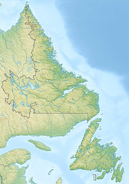
Quadratische Plattkarte, N-S-Streckung 160 %. Geographische Begrenzung der Karte:
Equirectangular projection, N/S stretching 160 %. Geographic limits of the map:
|
| Datum | |
| Boarne |
Eigen wurk, using
|
| Auteur | Carport |
| Tastimming (Reusing this file) |
This file is licensed under the Creative Commons Attribution-Share Alike 3.0 Unported license.
|
| Oare ferzjes |
|

Triemskiednis
Klik op in datum/tiid om it bestân te besjen sa't it op dat stuit wie.
| Datum/Tiid | Miniatuer | ôfmjittings | Meidogger | Opmerking | |
|---|---|---|---|---|---|
| lêste | 11 des 2012, 20.28 | | 1.680 × 2.402 (1,45 MB) | Carport | {{Information |Description= {{de|Physische Positionskarte von Neufundland und Labrador, Kanada}} Quadratische Plattkarte, N-S-Streckung 160 %. Geographische Begrenzung der Karte: * N: 60.8° N * S: 46.5°... |
Bestânsgebrûk
De neikommende side brûkt dit bestân:
Globaal bestânsgebrûk
De neikommende oare wiki's brûke dit bestân:
- Gebrûk op ban.wikipedia.org
- Gebrûk op bg.wikipedia.org
- Gebrûk op ce.wikipedia.org
- Gebrûk op de.wikipedia.org
- Cape Spear
- Bell Island (Neufundland)
- Blow Me Down Provincial Park
- Twillingate Islands
- Smallwood Reservoir
- Avalon (Halbinsel)
- Long Range Mountains
- The Cabox
- Wikipedia:Kartenwerkstatt/Positionskarten/Nordamerika
- Fogo Island
- Vorlage:Positionskarte Kanada Neufundland und Labrador
- Landsat Island
- Belle-Isle-Straße
- Belle Isle (Neufundland und Labrador)
- Killiniq Island
- Kap Race
- Great Northern Peninsula
- Mistastin Lake
- Atikonak Lake
- Lac Joseph
- Ashuanipi Lake
- Hamilton Inlet
- Lake Melville
- Dildo Island
- Bay of Islands (Neufundland)
- Vorlage:Positionskarte Kanada Neufundland
- Groais Island
- Ossokmanuan Reservoir
- Wasserkraftwerk Menihek Lakes
- St. Lewis Inlet
- Alexis Bay
- The Arches Provincial Park
- Dungeon Provincial Park
- Witless Bay Ecological Reserve
- Baccalieu Island Ecological Reserve
- Gannet Islands Ecological Reserve
- Hare Bay Islands Ecological Reserve
- Funk Island Ecological Reserve
- Funk Island
- Table Point Ecological Reserve
- Watts Point Ecological Reserve
- West Brook Ecological Reserve
- Sandy Cove Ecological Reserve
Mear globaal gebrûk fan dit bestân besjen.