
Ofbyld:Calgary street map.png
Grutte fan dit proefbyld: 483 × 600 piksels. Oare resolúsjes: 193 × 240 piksels | 386 × 480 piksels | 960 × 1.192 piksels.
Oarspronklik bestân (960 × 1.192 pixels, bestânsgrutte: 802 KB, MIME-type: image/png)
Gearfetting
| Beskriuwing |
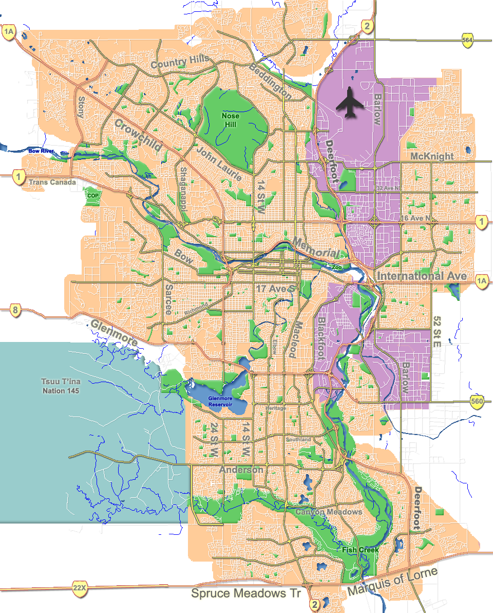
English: Outline map of Calgary. |
| Datum | |
| Boarne | GIS data |
| Auteur | Qyd |
| Oare ferzjes |
Derivative works of this file: |
| Camera location | | View this and other nearby images on: OpenStreetMap |
|---|
Lisinsje
| I, the copyright holder of this work, release this work into the public domain. This applies worldwide. In some countries this may not be legally possible; if so: I grant anyone the right to use this work for any purpose, without any conditions, unless such conditions are required by law. |
Triemskiednis
Klik op in datum/tiid om it bestân te besjen sa't it op dat stuit wie.
| Datum/Tiid | Miniatuer | ôfmjittings | Meidogger | Opmerking | |
|---|---|---|---|---|---|
| lêste | 7 okt 2007, 20.31 | | 960 × 1.192 (802 KB) | Qyd | fix highway name |
| 18 apr 2007, 21.44 |  | 960 × 1.192 (791 KB) | Qyd | spelling | |
| 18 sep 2006, 19.28 |  | 960 × 1.192 (792 KB) | Qyd | outline industrial areas | |
| 16 aug 2006, 19.20 |  | 960 × 1.192 (802 KB) | Qyd | added airport symbol and highway shields | |
| 14 aug 2006, 17.21 |  | 960 × 1.192 (797 KB) | Qyd | fixed interchanges | |
| 14 aug 2006, 06.46 |  | 960 × 1.192 (700 KB) | Qyd | added city parks | |
| 14 aug 2006, 06.19 |  | 960 × 1.192 (645 KB) | Qyd | highways names added | |
| 14 aug 2006, 02.17 |  | 960 × 1.192 (491 KB) | Qyd | {{Information |Description= Outline map of Calgary |Source=GIS data |Date=Aug 2006 |Author=Qyd |Permission=All |other_versions=Image:CalgaryAB-map.png }} Category:Calgary Category:Maps of cities in Canada |
Bestânsgebrûk
De neikommende 2 siden brûke dit bestân:
Globaal bestânsgebrûk
De neikommende oare wiki's brûke dit bestân:
- Gebrûk op ar.wikipedia.org
- Gebrûk op ast.wikipedia.org
- Gebrûk op bh.wikipedia.org
- Gebrûk op bn.wikipedia.org
- Gebrûk op cy.wikipedia.org
- Gebrûk op da.wikipedia.org
- Gebrûk op en.wikipedia.org
- McMahon Stadium
- Glenmore Reservoir
- Alberta University of the Arts
- Fish Creek Provincial Park
- Heritage Park Historical Village
- Beltline, Calgary
- Nose Hill Park
- Bowness, Calgary
- Kensington, Calgary
- Chinatown, Calgary
- Tsuu T'ina 145
- Inglewood, Calgary
- McKenzie Lake, Calgary
- Eau Claire, Calgary
- Downtown Calgary
- Foothills Medical Centre
- McKenzie Towne, Calgary
- MNP Community & Sport Centre
- List of neighbourhoods in Calgary
- Lakeview, Calgary
- Chinook Centre
- Parkdale, Calgary
- Mission, Calgary
- Marda Loop, Calgary
- Bankview, Calgary
- Mount Royal, Calgary
- Springbank Hill, Calgary
- List of airports in the Calgary area
- Telus Spark Science Centre
- Edgemont, Calgary
- Pineridge, Calgary
- Edworthy Park
- Lake Bonavista, Calgary
- Confederation Park, Calgary
- University Heights, Calgary
- The Military Museums
- Transportation in Calgary
- User:Qyd/Maps
- Market Mall
Mear globaal gebrûk fan dit bestân besjen.