
Ofbyld:Bobcat Lynx rufus distribution map.png

Oarspronklik bestân (704 × 800 pixels, bestânsgrutte: 124 KB, MIME-type: image/png)
Gearfetting
| Beskriuwing |
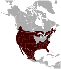
English: Geographical distribution of the Bobcat Lynx rufus, with national borders added. The map was created using the Generic Mapping Tools, GMT, version 5.1.1. |
| Datum | |
| Boarne |
Own work using: the IUCN Red List spatial data to draw the borders of the Lynx rufus range: |
| Auteur | Darekk2 using the IUCN Red List spatial data |
| Oare ferzjes |
|

Lisinsje
Attribution: The author of the work and the IUCN Red List spatial data.
You must provide the appropriate credit for the IUCN Red List spatial data:
IUCN (International Union for Conservation of Nature) 2008. Lynx rufus. In: IUCN 2014. The IUCN Red List of Threatened Species. Version 2014.3. http://www.iucnredlist.org. Downloaded on 25 February 2015.
and the IUCN Red List spatial data
- Fiel jo frij:
- te dielen – it wurk te kopiearjen, fersprieden en út te stjoeren
- te fermingen – it wurk oan te passen
- Under de neikommende betingsten:
- Nammefermelding – You must give appropriate credit, provide a link to the license, and indicate if changes were made. You may do so in any reasonable manner, but not in any way that suggests the licensor endorses you or your use.
- Lyk diele – If you remix, transform, or build upon the material, you must distribute your contributions under the same or compatible license as the original.
Triemskiednis
Klik op in datum/tiid om it bestân te besjen sa't it op dat stuit wie.
| Datum/Tiid | Miniatuer | ôfmjittings | Meidogger | Opmerking | |
|---|---|---|---|---|---|
| lêste | 27 mai 2015, 01.53 | | 704 × 800 (124 KB) | Darekk2 | thicker borders of states |
| 20 mrt 2015, 19.30 |  | 703 × 800 (117 KB) | Darekk2 | removed transparency of the background | |
| 15 mrt 2015, 18.19 |  | 703 × 800 (129 KB) | Darekk2 | previously an incorrect map was used as the background, the range in Mexico was incomplete | |
| 15 mrt 2015, 18.10 |  | 800 × 771 (139 KB) | Darekk2 | uncovered Lake Superior ... | |
| 25 feb 2015, 18.09 |  | 705 × 800 (128 KB) | Darekk2 | User created page with UploadWizard |
Bestânsgebrûk
De neikommende side brûkt dit bestân:
Globaal bestânsgebrûk
De neikommende oare wiki's brûke dit bestân:
- Gebrûk op en.wikipedia.org
- Gebrûk op tr.wikipedia.org
- Gebrûk op vi.wikipedia.org