
Ofbyld:Andorra map.png
Gjin hegere resolúsje beskikber.
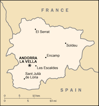
Andorra_map.png (329 × 354 pixels, bestânsgrutte: 6 KB, MIME-type: image/png)
Gearfetting
| Beskriuwing | Andorra map from CIA World Factbook, converted from original GIF format |
| Datum | |
| Boarne | CIA World Factbook |
| Auteur | United States Central Intelligence Agency |

|
Ofbyld:Andorra map.svg is in fektorferzje fan dizze triem. As net fan sljochtere kwaliteit tsjinnet dizze brûkt te wurden yn plak fan dizze rasterôfbylding.
File:Andorra map.png → File:Andorra map.svg
Sjoch Help:SVG foar mear ynformaasje. |
 |
Lisinsje
This image is in the public domain because it contains materials that originally came from the United States Central Intelligence Agency's World Factbook.
|
 |
Triemskiednis
Klik op in datum/tiid om it bestân te besjen sa't it op dat stuit wie.
| Datum/Tiid | Miniatuer | ôfmjittings | Meidogger | Opmerking | |
|---|---|---|---|---|---|
| lêste | 18 sep 2012, 00.55 | | 329 × 354 (6 KB) | OgreBot | (BOT): Uploading old version of file from en.wikipedia; originally uploaded on 2005-05-23 07:38:15 by Berkut |
| 27 nov 2004, 22.23 |  | 330 × 355 (12 KB) | Kneiphof | Andorra CIA map |
Bestânsgebrûk
Der binne gjin siden dy't dit bestân brûke.
Globaal bestânsgebrûk
De neikommende oare wiki's brûke dit bestân:
- Gebrûk op af.wikipedia.org
- Gebrûk op az.wikipedia.org
- Gebrûk op be-tarask.wikipedia.org
- Gebrûk op br.wikipedia.org
- Gebrûk op ca.wikipedia.org
- Gebrûk op ckb.wikipedia.org
- Gebrûk op cy.wikipedia.org
- Gebrûk op de.wikipedia.org
- Gebrûk op dsb.wikipedia.org
- Gebrûk op en.wikipedia.org
- Gebrûk op en.wikisource.org
- Gebrûk op fa.wikipedia.org
- Gebrûk op fi.wikipedia.org
- Gebrûk op gag.wikipedia.org
- Gebrûk op gom.wikipedia.org
- Gebrûk op ia.wikipedia.org
- Gebrûk op id.wikipedia.org
- Gebrûk op ilo.wikipedia.org
- Gebrûk op it.wikipedia.org
- Gebrûk op ja.wikipedia.org
- Gebrûk op kn.wikipedia.org
- Gebrûk op ko.wikipedia.org
- Gebrûk op lfn.wikipedia.org
- Gebrûk op lt.wikipedia.org
- Gebrûk op mi.wikipedia.org
- Gebrûk op ml.wikipedia.org
- Gebrûk op ms.wikipedia.org
- Gebrûk op mzn.wikipedia.org
- Gebrûk op nds.wikipedia.org
- Gebrûk op nl.wiktionary.org
- Gebrûk op ro.wikibooks.org
- Gebrûk op sat.wikipedia.org
Mear globaal gebrûk fan dit bestân besjen.