
Ofbyld:AbuDisWall.jpg
Gjin hegere resolúsje beskikber.
AbuDisWall.jpg (800 × 410 pixels, bestânsgrutte: 61 KB, MIME-type: image/jpeg)
| Beskriuwing |
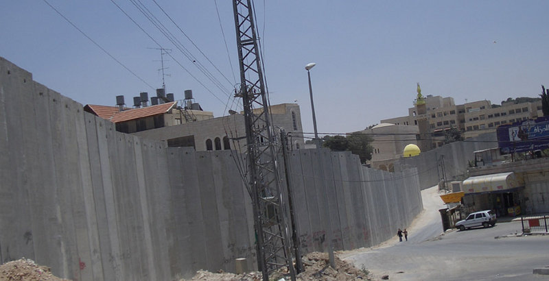
English: Israeli separation barrier at Abu Dis, June 2004. This picture shows a portion of the barrier being built by Israel in the West Bank. This part is in Abu Dis, close to the eastern part of Jerusalem. The photo was taken on the Jerusalem side of the wall, facing south. The local residents on both sides of the barrier at this point are predominantly Arabs.
Deutsch: Israelische Sperrmauer in Abu Dis nahe Ostjerusalems (Juni 2004). Das Photo zeigt die Mauer auf der Jerusalemer Seite Richtung Süden. An dieser Stelle sind die meisten Bewohner auf beiden Seiten der Mauer Araber. |
| Datum | |
| Boarne | from en wikipedia where it was uploaded as own work |
| Auteur | Zero |
| Object location | | View this and other nearby images on: OpenStreetMap |
|---|
Zero0000 from en.wikipedia.org, the copyright holder of this work, hereby publishes it under the following license:
| This file is licensed under the Creative Commons Attribution-Share Alike 3.0 Unported license. Subject to disclaimers. | ||
| Nammefermelding: Zero0000 from en.wikipedia.org | ||
| ||
| This licensing tag was added to this file as part of the GFDL licensing update. |

|
Der wurdt tastimming jûn ta kopiearjen, fersprieden en/of wizigjen fan dit dokumint ûnder de betinksten fan de GNU-lisinsje foar iepen dokumintaasje, ferzje 1.2, as eltse lettere ferzje útjûn troch de Free Software Foundation; sûnder Ynfariante Seksjes, sûnder Omkaftteksten foar de Foarkante en sûnder Omkaftteksten foar de Efterkante. In kopy fan de lisinsje is opnaam yn de seksje "Text of the GNU Free Documentation License". Subject to disclaimers. |
Triemskiednis
Klik op in datum/tiid om it bestân te besjen sa't it op dat stuit wie.
| Datum/Tiid | Miniatuer | ôfmjittings | Meidogger | Opmerking | |
|---|---|---|---|---|---|
| lêste | 26 jun 2005, 15.16 | | 800 × 410 (61 KB) | Matanya (usurped) | from en wikipedia. Israeli separation barrier at Abu Dis, June 2004 This picture shows a portion of the barrier being built by Israel in the West Bank. This part is in Abu Dis, close to the eastern part of Jerusalem. The photo was taken on the Jerusale |
Bestânsgebrûk
De neikommende side brûkt dit bestân:
Globaal bestânsgebrûk
De neikommende oare wiki's brûke dit bestân:
- Gebrûk op ar.wikipedia.org
- Gebrûk op bn.wikipedia.org
- Gebrûk op de.wikipedia.org
- Gebrûk op el.wikipedia.org
- Gebrûk op en.wikipedia.org
- Gebrûk op eo.wikipedia.org
- Gebrûk op gl.wikipedia.org
- Gebrûk op he.wikipedia.org
- Gebrûk op hy.wikipedia.org
- Gebrûk op nl.wikipedia.org
- Gebrûk op ru.wikipedia.org
- Gebrûk op ru.wikinews.org
- Gebrûk op simple.wikipedia.org
- Gebrûk op tr.wikipedia.org
- Gebrûk op zh.wikipedia.org