
Ofbyld:East Galicia and Volhynia 1939.png
Gjin hegere resolúsje beskikber.
East_Galicia_and_Volhynia_1939.png (600 × 450 pixels, bestânsgrutte: 74 KB, MIME-type: image/png)
Gearfetting
| Beskriuwing |
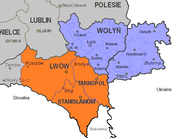
English: Map of the south-eastern part of Poland, within the borders of 1921-1939, as well as the eastern part of Volhynia. Highlighted in orange colour are the three Polish voivodeships of Lwów, Stanisławów, and Tarnopol which form the eastern part of Galicia. Areas in grey are other Polish voivodeships. In blue the Polish voivodeship of Wołyń, with the black border separating the eastern part which was part of the Ukrainian Soviet Socialist Republic. Both parts form the historical region of Volhynia. The internal borders in blue in Volhynia are the old pre-war districts with their capital towns.
Abbreviations of towns in Volhynia: |
| Datum | |
| Boarne | Eigen wurk |
| Auteur | Gryffindor |
| Oare ferzjes |
 |
Lisinsje
I, the copyright holder of this work, hereby publish it under the following license:
| This file is made available under the Creative Commons CC0 1.0 Universal Public Domain Dedication. | |
| The person who associated a work with this deed has dedicated the work to the public domain by waiving all of their rights to the work worldwide under copyright law, including all related and neighboring rights, to the extent allowed by law. You can copy, modify, distribute and perform the work, even for commercial purposes, all without asking permission.
|
| Annotations | This image is annotated: View the annotations at Commons |
Triemskiednis
Klik op in datum/tiid om it bestân te besjen sa't it op dat stuit wie.
| Datum/Tiid | Miniatuer | ôfmjittings | Meidogger | Opmerking | |
|---|---|---|---|---|---|
| lêste | 14 nov 2013, 14.20 | | 600 × 450 (74 KB) | Gryffindor | {{Information |Description={{en|Map of the south-eastern part of Poland, within the borders of 1921-1939, as well as the eastern part of Volhynia. Highlighted in orange colour are the three Polish voivodeships of Lwów, Stanisławów, and Tarnopol whic... |
Bestânsgebrûk
De neikommende side brûkt dit bestân:
Globaal bestânsgebrûk
De neikommende oare wiki's brûke dit bestân:
- Gebrûk op ca.wikipedia.org
- Gebrûk op cs.wikipedia.org
- Gebrûk op el.wikipedia.org
- Gebrûk op en.wikipedia.org
- Gebrûk op gl.wikipedia.org
- Gebrûk op it.wikipedia.org
- Gebrûk op pl.wikipedia.org
- Gebrûk op sl.wikipedia.org
- Gebrûk op tt.wikipedia.org
- Gebrûk op vi.wikipedia.org