Ofbyld:Canada2.A2002165.1940.250m.jpg

Grutte fan dit proefbyld: 461 × 599 piksels. Oare resolúsjes: 184 × 240 piksels | 369 × 480 piksels | 591 × 768 piksels | 788 × 1.024 piksels | 1.575 × 2.048 piksels | 4.000 × 5.200 piksels.
Oarspronklik bestân (4.000 × 5.200 pixels, bestânsgrutte: 2,83 MB, MIME-type: image/jpeg)
Triemskiednis
Klik op in datum/tiid om it bestân te besjen sa't it op dat stuit wie.
| Datum/Tiid | Miniatuer | ôfmjittings | Meidogger | Opmerking | |
|---|---|---|---|---|---|
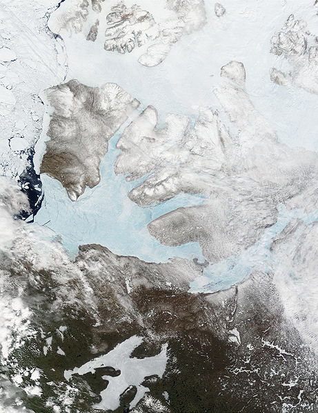
| lêste | 20 aug 2008, 19.59 |  | 4.000 × 5.200 (2,83 MB) | Ando228 | {{Information |Description={{en|1=These Moderate resolution Imaging Spectroradiometer Images from June 14 and 16, 2002, show Banks Island (upper left) and Victoria Island (to the southeast) in the Arctic Ocean off northwest Canada. Left of center in each |
Bestânsgebrûk
De neikommende side brûkt dit bestân:
Globaal bestânsgebrûk
De neikommende oare wiki's brûke dit bestân:
- Gebrûk op af.wikipedia.org
- Gebrûk op ar.wikipedia.org
- Gebrûk op ast.wikipedia.org
- Gebrûk op az.wikipedia.org
- Gebrûk op be.wikipedia.org
- Gebrûk op bg.wikipedia.org
- Gebrûk op bn.wikipedia.org
- Gebrûk op ca.wikipedia.org
- Gebrûk op ceb.wikipedia.org
- Gebrûk op cy.wikipedia.org
- Gebrûk op da.wikipedia.org
- Gebrûk op de.wikivoyage.org
- Gebrûk op diq.wikipedia.org
- Gebrûk op en.wikipedia.org
- Gebrûk op es.wikipedia.org
- Gebrûk op eu.wikipedia.org
- Gebrûk op fa.wikipedia.org
- Gebrûk op fi.wikipedia.org
- Gebrûk op fr.wikipedia.org
- Gebrûk op fr.wikivoyage.org
- Gebrûk op ga.wikipedia.org
- Gebrûk op gl.wikipedia.org
- Gebrûk op he.wikipedia.org
- Gebrûk op hu.wikipedia.org
- Gebrûk op hy.wikipedia.org
- Gebrûk op ilo.wikipedia.org
- Gebrûk op is.wikipedia.org
- Gebrûk op it.wikipedia.org
- Gebrûk op ja.wikipedia.org
- Gebrûk op ko.wikipedia.org
- Gebrûk op ku.wikipedia.org
- Gebrûk op la.wikipedia.org
- Gebrûk op lv.wikipedia.org
- Gebrûk op ml.wikipedia.org
- Gebrûk op mzn.wikipedia.org
- Gebrûk op nl.wikipedia.org
- Gebrûk op nn.wikipedia.org
- Gebrûk op no.wikipedia.org
Mear globaal gebrûk fan dit bestân besjen.


