
Canterbury: ferskil tusken ferzjes
Nije Side: {{wurk}} thumb|250px|Canterbury oan de rivier Stour [[File:Canterbury - Turm der St. George's Church, in der Marlowe getauft wurde... |
No edit summary |
||
| Rigel 14: | Rigel 14: | ||
In [[1178]] en in [[1276]] vonden in Canterbury grote [[stadsbrand]]en plaats. |
In [[1178]] en in [[1276]] vonden in Canterbury grote [[stadsbrand]]en plaats. |
||
== |
== Demografy == |
||
{| class="wikitable" id="toc" style="float: centre; margin-left: 2em; width: 40%; font-size: 90%;" cellspacing="3" |
{| class="wikitable" id="toc" style="float: centre; margin-left: 2em; width: 40%; font-size: 90%;" cellspacing="3" |
||
!colspan="4"|'''Canterbury compared''' |
!colspan="4"|'''Canterbury compared''' |
||
|- |
|- |
||
|'''2001 UK Census'''||''' |
|'''2001 UK Census'''||'''Stêd Canterbury'''||'''Distrikt Canterbury'''||'''Ingelân''' |
||
|- |
|- |
||
| |
|Totale befolking||43,432||135,278||49,138,831 |
||
|- |
|- |
||
| |
|Net lânseigen||11.6%||5.1%||9.2% |
||
|- |
|- |
||
| |
|Blank||95%||97%||91% |
||
|- |
|- |
||
| |
|Asiatysk||1.8%||1.6%||4.6% |
||
|- |
|- |
||
| |
|Swart||0.7%||0.5%||2.3% |
||
|- |
|- |
||
| |
|Kristen||68%||73%||72% |
||
|- |
|- |
||
| |
|Moslim||1.1%||0.6%||3.1% |
||
|- |
|- |
||
|Hindu||0.8%||0.4%||1.1% |
|Hindu||0.8%||0.4%||1.1% |
||
|- |
|- |
||
| |
|Gjin religy||20%||17%||15% |
||
|- |
|- |
||
| |
|Wurkleas||3.0%||2.7%||3.3% |
||
|} |
|} |
||
{{clr}} |
{{clr}} |
||
As of the [[United Kingdom Census 2001|2001 UK censusthe total population of the city's urban area wards was 43,432. |
|||
As of the [[United Kingdom Census 2001|2001 UK census]],<ref name="Statistics Barton (Ward)">{{cite web | title = Barton (Ward) | publisher = Statistics.gov.uk | url = http://neighbourhood.statistics.gov.uk/dissemination/LeadDomainList.do?a=3&c=Barton&d=14&i=1001x1002&m=0&r=1&s=1211928639406&enc=1&areaId=5945407&OAAreaId=457094 | accessdate = 2008-05-27 }}</ref><ref name="Statistics Harbledown (Ward)">{{cite web | title =Harbledown (Ward) | publisher = Statistics.gov.uk | url = http://neighbourhood.statistics.gov.uk/dissemination/LeadAreaSearch.do?a=3&r=1&i=1001&m=0&s=1211928705328&enc=1&areaSearchText=Harbledown&areaSearchType=14&extendedList=false&searchAreas=Search | accessdate = 2008-05-27 }}</ref><ref name="Statistics Northgate (Ward)">{{cite web | title = Northgate (Ward) | publisher = Statistics.gov.uk | url = http://www.neighbourhood.statistics.gov.uk/dissemination/LeadDomainList.do?a=3&c=Northgate&d=14&i=1001x1002&m=0&r=1&s=1211928715562&enc=1&areaId=5945394&OAAreaId=457324 | accessdate = 2008-05-27 }}</ref><ref name="Statistics St Stephens (Ward)">{{cite web | title = St Stephens (Ward) | publisher = Statistics.gov.uk | url = http://www.neighbourhood.statistics.gov.uk/dissemination/LeadDomainList.do?a=3&c=St+Stephens&d=14&i=1001x1002&m=0&r=1&s=1211928726968&enc=1&areaId=5945392&OAAreaId=457370 | accessdate = 2008-05-27 }}</ref><ref name="Statistics Westgate (Ward)">{{cite web | title = Westgate (Ward) | publisher = Statistics.gov.uk | url = http://www.neighbourhood.statistics.gov.uk/dissemination/LeadDomainList.do?a=3&c=Westgate&d=14&i=1001x1002&m=0&r=1&s=1211928736203&enc=1&areaId=5945386&OAAreaId=457480 | accessdate = 2008-05-27 }}</ref><ref name="Statistics Wincheap (Ward)">{{cite web | title = Wincheap (Ward) | publisher = Statistics.gov.uk | url =http://www.neighbourhood.statistics.gov.uk/dissemination/LeadAreaSearch.do?a=3&i=1001&m=0&s=1211928689359&enc=1&areaSearchText=Wincheap&areaSearchType=14&extendedList=false&searchAreas=Search | accessdate = 2008-05-27 }}</ref> the total population of the city's urban area wards was 43,432. |
|||
Residents of the city had an average age of 37.1 years, younger than the 40.2 average throughout the district and the 38.6 average for England. Of the 17,536 households, 35% were one-person households, 39% were couples, 10% were lone parents, and 15% other. Of those aged 16–74 in the city, 27% had a [[higher education]] qualification, higher than the 20% national average. |
Residents of the city had an average age of 37.1 years, younger than the 40.2 average throughout the district and the 38.6 average for England. Of the 17,536 households, 35% were one-person households, 39% were couples, 10% were lone parents, and 15% other. Of those aged 16–74 in the city, 27% had a [[higher education]] qualification, higher than the 20% national average. |
||
| Rigel 48: | Rigel 48: | ||
{| class="wikitable" style="font-size:90%;width:70%;border:0px;text-align:center;line-height:120%;" |
{| class="wikitable" style="font-size:90%;width:70%;border:0px;text-align:center;line-height:120%;" |
||
! colspan="19" style="text-align:center;font-size:90%;"| |
! colspan="19" style="text-align:center;font-size:90%;"|Befolkingsgroei yn Canterbury sûnt 1901 |
||
|- |
|- |
||
! style="background: #99CCCC; color: #000080" height="17" | |
! style="background: #99CCCC; color: #000080" height="17" | Jier |
||
! style="background: #FFFFFF; color:#000080;" | 1901 |
! style="background: #FFFFFF; color:#000080;" | 1901 |
||
! style="background: #FFFFFF; color:#000080;" | 1911 |
! style="background: #FFFFFF; color:#000080;" | 1911 |
||
| Rigel 61: | Rigel 61: | ||
! style="background: #FFFFFF; color:#000080;" | 2001 |
! style="background: #FFFFFF; color:#000080;" | 2001 |
||
|- Align="center" |
|- Align="center" |
||
! style="background: #99CCCC; color: #000080" height="17" | |
! style="background: #99CCCC; color: #000080" height="17" | Befolking |
||
| style="background: #FFFFFF; color: black;" | 24,899 |
| style="background: #FFFFFF; color: black;" | 24,899 |
||
| style="background: #FFFFFF; color: black;" | 24,626 |
| style="background: #FFFFFF; color: black;" | 24,626 |
||
| Rigel 87: | Rigel 87: | ||
== Foto's == |
== Foto's == |
||
<gallery> |
<gallery> |
||
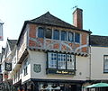
Ofbyld:Canterbury Burgate.jpg| |
Ofbyld:Canterbury Burgate.jpg|âlde huzen yn Canterbury |
||
Ofbyld:Canterbury Cathedral Gate.jpg| |
Ofbyld:Canterbury Cathedral Gate.jpg|tagongspoarte fan de katedraal |
||
Ofbyld:Canterbury - Klein-Venedig am Stour.jpg| |
Ofbyld:Canterbury - Klein-Venedig am Stour.jpg|It hûs "The Weavers" oan de rivier Stour |
||
Ofbyld:Canterbury Westgate.jpg|de "Westgate", |
Ofbyld:Canterbury Westgate.jpg|de "Westgate", midsieuske stedspoarte |
||
</gallery> |
</gallery> |
||
== Keppelings om utens == |
|||
{{Commons|Canterbury}} |
|||
* [http://www.canterbury.gov.uk/ Canterbury, stedsbestjoer] |
|||
* [http://www.canterbury.co.uk/ Canterbury, tûristyske ynformaasje] |
|||
* [http://www.canterbury-cathedral.org/ Katedraal Canterbury] |
|||
* [http://www.canterburybuildings.com/ Canterbury Buildings website] - Argeologyske- en erfguodside oer gebouwen yn Canterbury. |
|||
* [http://www.canterburytrust.co.uk/archive/bigdig01.html Canterbury Archaeological Trust - de Whitefriars opgravingen] |
|||
* [http://whc.unesco.org/en/list/496 UNESCO World Heritage Centre] - Wrâlderfguodprofyl Canterbury. |
|||
{{boarnen|boarnefernijing= |
|||
<references/> |
|||
}} |
|||
{{Koördinaten|51_16_42_N_1_04_39_E_type:city_region:GB|51¦ 16' N, 1¦ 4' O}} |
{{Koördinaten|51_16_42_N_1_04_39_E_type:city_region:GB|51¦ 16' N, 1¦ 4' O}} |
||
De ferzje fan 20 aug 2010 om 17.57
Fier hjir asjebleaft gjin bewurkings út oant de skriuwer mei de side klear is. |
|---|


Canterbury (Nederlands, ferâldere: Kantelberg) is in stêd (city) yn it greefskip Kent yn it súdeasten fan Ingelân. It is de sit fan de aartsbiskop fan Canterbury, de primaat fan de Anglikaanse Tsjerke. De stad ligt aan de rivier de Stour en heeft ca. 35.000 inwoners. Het is een regionaal centrum met enige industrie (metaalferwurking, learyndustry, drukkerijen), maar de toeristische functie is het belangrijkst.
De aantrekkingskracht van Canterbury ligt in het middeleeuwse karakter van de binnenstad en vooral in de beroemde kathedraal. Hier liggen koning Hendrik IV en Eduard (de Swarte Prins, zoon fan kening Eduard III) begraven. Het bekendst is de kathedraal echter vanwege de moord op Thomas Becket in 1170. Door deze gebeurtenis werd Canterbury een pelgrimsoord, dat Geoffrey Chaucer inspireerde tot zijn meesterwerk, de Canterbury Tales. De stad had ook banden met de familie van Thomas More en was de geboorteplaats van toneelschrijver Christopher Marlowe.
Yn de Twadde wRâldkriich rekke de stêd swier skansearre troch bombardeminten. Veel oude gebouwen staan echter nog overeind of zijn hersteld en nieuwbouw in het oude deel van de stad is aan strenge regels gebonden.
Canterbury is ek in studintestêd. Der binne trije ynstituten foar heger ûnderwiis.
Skiednis
In 1178 en in 1276 vonden in Canterbury grote stadsbranden plaats.
Demografy
| Canterbury compared | |||
|---|---|---|---|
| 2001 UK Census | Stêd Canterbury | Distrikt Canterbury | Ingelân |
| Totale befolking | 43,432 | 135,278 | 49,138,831 |
| Net lânseigen | 11.6% | 5.1% | 9.2% |
| Blank | 95% | 97% | 91% |
| Asiatysk | 1.8% | 1.6% | 4.6% |
| Swart | 0.7% | 0.5% | 2.3% |
| Kristen | 68% | 73% | 72% |
| Moslim | 1.1% | 0.6% | 3.1% |
| Hindu | 0.8% | 0.4% | 1.1% |
| Gjin religy | 20% | 17% | 15% |
| Wurkleas | 3.0% | 2.7% | 3.3% |
Berjocht:Clr As of the [[United Kingdom Census 2001|2001 UK censusthe total population of the city's urban area wards was 43,432.
Residents of the city had an average age of 37.1 years, younger than the 40.2 average throughout the district and the 38.6 average for England. Of the 17,536 households, 35% were one-person households, 39% were couples, 10% were lone parents, and 15% other. Of those aged 16–74 in the city, 27% had a higher education qualification, higher than the 20% national average.
Compared with the rest of England, the city had an above-average proportion of foreign-born residents, at around 12%. Ninety-five percent of residents were recorded as white; the largest minority group was recorded as Asian, at 1.8% of the population. Religion was recorded as 68.2% Christian, 1.1% Muslim, 0.5% Buddhist, 0.8% Hindu, 0.2% Jewish, and 0.1% Sikh. The rest either had no religion, an alternative religion, or did not state their religion.
| Befolkingsgroei yn Canterbury sûnt 1901 | ||||||||||||||||||
|---|---|---|---|---|---|---|---|---|---|---|---|---|---|---|---|---|---|---|
| Jier | 1901 | 1911 | 1921 | 1931 | 1939 | 1951 | 1961 | 1971 | 2001 | |||||||||
| Befolking | 24,899 | 24,626 | 23,737 | 24,446 | 26,999 | 27,795 | 30,415 | 33,155 | 43,432 | |||||||||
| Source: A Vision of Britain through Time | ||||||||||||||||||
Wrâlderfgoed yn Canterbury
- Katedraal fan Canterbury
- Abdij fan St. Augustine
- St. Martin's Church
Berne yn Canterbury
- Christopher Marlowe (1564-1593), Engels dichter en toanielskriuwer
- Stephen Gray (1666-1736), wittenskipper en astronoom
- Orlando Bloom (13 jannewaris 1977), akteur
Foto's
-
 âlde huzen yn Canterbury
 -
 tagongspoarte fan de katedraal
 -
 It hûs "The Weavers" oan de rivier Stour
 -
 de "Westgate", midsieuske stedspoarte


Keppelings om utens
- Canterbury, stedsbestjoer
- Canterbury, tûristyske ynformaasje
- Katedraal Canterbury
- Canterbury Buildings website - Argeologyske- en erfguodside oer gebouwen yn Canterbury.
- Canterbury Archaeological Trust - de Whitefriars opgravingen
- UNESCO World Heritage Centre - Wrâlderfguodprofyl Canterbury.
| Boarnen, noaten en/as referinsjes: |
| Ofbylden dy't by dit ûnderwerp hearre, binne te finen yn de kategory Canterbury fan Wikimedia Commons. |