
Ofbyld:WillebroekLocatie.png
Gjin hegere resolúsje beskikber.
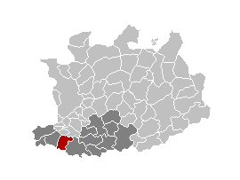
WillebroekLocatie.png (270 × 203 pixels, bestânsgrutte: 5 KB, MIME-type: image/png)

|
This locator map image could be re-created using vector graphics as an SVG file. This has several advantages; see Commons:Media for cleanup for more information. If an SVG form of this image is available, please upload it and afterwards replace this template with
{{vector version available|new image name}}.
It is recommended to name the SVG file “WillebroekLocatie.svg”—then the template Vector version available (or Vva) does not need the new image name parameter. |
from nl.wiki.
| This work has been released into the public domain by its author, LennartBolks. This applies worldwide. In some countries this may not be legally possible; if so: |
Triemskiednis
Klik op in datum/tiid om it bestân te besjen sa't it op dat stuit wie.
| Datum/Tiid | Miniatuer | ôfmjittings | Meidogger | Opmerking | |
|---|---|---|---|---|---|
| lêste | 11 apr 2006, 17.44 | | 270 × 203 (5 KB) | Profoss | from nl.wiki. {{PD-user|LennartBolks}} Category:Maps of province of Antwerp |
Bestânsgebrûk
De neikommende side brûkt dit bestân:
Globaal bestânsgebrûk
De neikommende oare wiki's brûke dit bestân:
- Gebrûk op br.wikipedia.org
- Gebrûk op eo.wikipedia.org
- Gebrûk op fa.wikipedia.org
- Gebrûk op fi.wikipedia.org
- Gebrûk op it.wikipedia.org
- Gebrûk op nl.wikipedia.org
- Gebrûk op pl.wikipedia.org
- Gebrûk op pt.wikipedia.org
- Gebrûk op ro.wikipedia.org
- Gebrûk op sk.wikipedia.org
- Gebrûk op tr.wikipedia.org
- Gebrûk op vi.wikipedia.org