
Ofbyld:Urartu 715 713-en.svg

Size of this PNG preview of this SVG file: 800 × 513 piksels. Oare resolúsjes: 320 × 205 piksels | 640 × 410 piksels | 1.024 × 657 piksels | 1.280 × 821 piksels | 2.560 × 1.641 piksels | 2.714 × 1.740 piksels.
Oarspronklik bestân (SVG-bestân, nominaal 2.714 × 1.740 pixels, bestânsgrutte: 881 KB)
Gearfetting
| Beskriuwing |
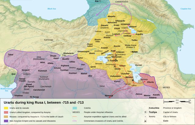
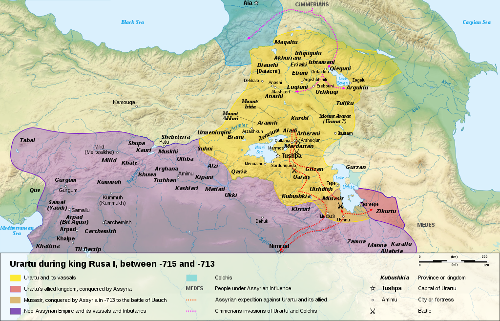
English: Map of the kingdom of Urartu, between -715 and -713.
Français : Carte en anglais du royaume d'Urartu, entre -715 et -713. |
||
| Datum | |||
| Boarne |
Own work.
Sources :
Software used :
Other data :
|
||
| Auteur | Sémhur | ||
| Oare ferzjes |
See Urartu.
| ||
| Nammefermelding (required by the license) | © Sémhur / Wikimedia Commons / | ||
| SVG | W3C-validity not checked.
|
||
| Atelier graphique |


| Camera location | | View this and other nearby images on: OpenStreetMap |
|---|
Lisinsje
I, the copyright holder of this work, hereby publish it under the following licenses:
| Copyleft: This work of art is free; you can redistribute it and/or modify it according to terms of the Free Art License. You will find a specimen of this license on the Copyleft Attitude site as well as on other sites. |
This file is licensed under the Creative Commons Attribution-Share Alike 4.0 International, 3.0 Unported, 2.5 Generic, 2.0 Generic and 1.0 Generic license.
- Fiel jo frij:
- te dielen – it wurk te kopiearjen, fersprieden en út te stjoeren
- te fermingen – it wurk oan te passen
- Under de neikommende betingsten:
- Nammefermelding – You must give appropriate credit, provide a link to the license, and indicate if changes were made. You may do so in any reasonable manner, but not in any way that suggests the licensor endorses you or your use.
- Lyk diele – If you remix, transform, or build upon the material, you must distribute your contributions under the same or compatible license as the original.
You may select the license of your choice.
| Annotations | This image is annotated: View the annotations at Commons |
Triemskiednis
Klik op in datum/tiid om it bestân te besjen sa't it op dat stuit wie.
| Datum/Tiid | Miniatuer | ôfmjittings | Meidogger | Opmerking | |
|---|---|---|---|---|---|
| lêste | 10 jan 2008, 18.15 | | 2.714 × 1.740 (881 KB) | Sémhur | == Description == {{Information |Description= {{en| Map of the kingdom of Urartu, between -715 and -713.}} {{fr| Carte en anglais du royaume d'Urartu, entre -715 et -713.}} |Source=Own work. {{clr}} Sources : * Topographic background : [http://www2.jpl.na |
Bestânsgebrûk
De neikommende 3 siden brûke dit bestân:
Globaal bestânsgebrûk
De neikommende oare wiki's brûke dit bestân:
- Gebrûk op als.wikipedia.org
- Gebrûk op ast.wikipedia.org
- Gebrûk op avk.wikipedia.org
- Gebrûk op azb.wikipedia.org
- Gebrûk op bg.wikipedia.org
- Gebrûk op ckb.wikipedia.org
- Gebrûk op cs.wikipedia.org
- Gebrûk op de.wikipedia.org
- Gebrûk op en.wikipedia.org
- Gebrûk op eo.wikipedia.org
- Gebrûk op et.wikipedia.org
- Gebrûk op fr.wikipedia.org
- Gebrûk op gl.wikipedia.org
- Gebrûk op hy.wikipedia.org
- Gebrûk op id.wikipedia.org
- Gebrûk op ja.wikipedia.org
- Gebrûk op ka.wikipedia.org
- Gebrûk op mt.wikipedia.org
- Gebrûk op no.wikipedia.org
- Gebrûk op pl.wikipedia.org
- Gebrûk op pnb.wikipedia.org
- Gebrûk op sl.wikipedia.org
- Gebrûk op sr.wikipedia.org
- Gebrûk op tr.wikipedia.org
Mear globaal gebrûk fan dit bestân besjen.