
Ofbyld:USA Territorial Growth small.gif
Gjin hegere resolúsje beskikber.
USA_Territorial_Growth_small.gif (431 × 287 pixels, bestânsgrutte: 456 KB, MIME-type: image/gif, looped, 10 frames, 30 s)

|
This file has been superseded by USA territorial growth.gif. It is recommended to use the other file. Please note that deleting superseded images requires consent.
|

|
Gearfetting
| Beskriuwing |
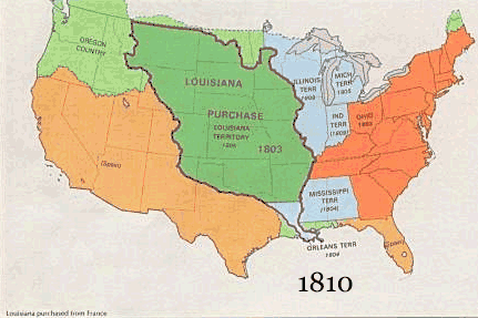
English: US territorial growth 1810–1920, based on the PD USGS maps in Category:Territorial growth maps of the United States.
See key below for explanation of colors.  |
||||||
| Boarne |
|
||||||
| Auteur |
|
||||||
| Oare ferzjes |
|
Lisinsje
This image is in the public domain in the United States because it only contains materials that originally came from the United States Geological Survey, an agency of the United States Department of the Interior. For more information, see the official USGS copyright policy.
|
Triemskiednis
Klik op in datum/tiid om it bestân te besjen sa't it op dat stuit wie.
| Datum/Tiid | Miniatuer | ôfmjittings | Meidogger | Opmerking | |
|---|---|---|---|---|---|
| lêste | 30 mai 2006, 12.50 | | 431 × 287 (456 KB) | Roke~commonswiki | US territorial growth, based on the PD USGS maps in Category:USA Territorial Growth Maps Category: USA Territorial Growth Maps {{PD-USGov-USGS}} |
Bestânsgebrûk
De neikommende side brûkt dit bestân:
Globaal bestânsgebrûk
De neikommende oare wiki's brûke dit bestân:
- Gebrûk op ar.wikipedia.org
- Gebrûk op be-tarask.wikipedia.org
- Gebrûk op be.wikipedia.org
- Gebrûk op ca.wikipedia.org
- Gebrûk op ckb.wikipedia.org
- Gebrûk op da.wikipedia.org
- Gebrûk op fr.wikipedia.org
- Gebrûk op gcr.wikipedia.org
- Gebrûk op hr.wikipedia.org
- Gebrûk op id.wikipedia.org
- Gebrûk op it.wikipedia.org
- Gebrûk op jv.wikipedia.org
- Gebrûk op kk.wikipedia.org
- Gebrûk op ro.wikipedia.org
- Gebrûk op sh.wikipedia.org
- Gebrûk op sl.wikipedia.org
- Gebrûk op sr.wikipedia.org
- Gebrûk op tr.wikipedia.org
- Gebrûk op uk.wikipedia.org