
Ofbyld:Txu-pclmaps-topo-us-saint lawrence-1970.jpg
Grutte fan dit proefbyld: 778 × 599 piksels. Oare resolúsjes: 312 × 240 piksels | 623 × 480 piksels | 997 × 768 piksels | 1.280 × 986 piksels | 2.560 × 1.972 piksels | 5.957 × 4.589 piksels.
Oarspronklik bestân (5.957 × 4.589 pixels, bestânsgrutte: 4,29 MB, MIME-type: image/jpeg)
Gearfetting
| Beskriuwing |
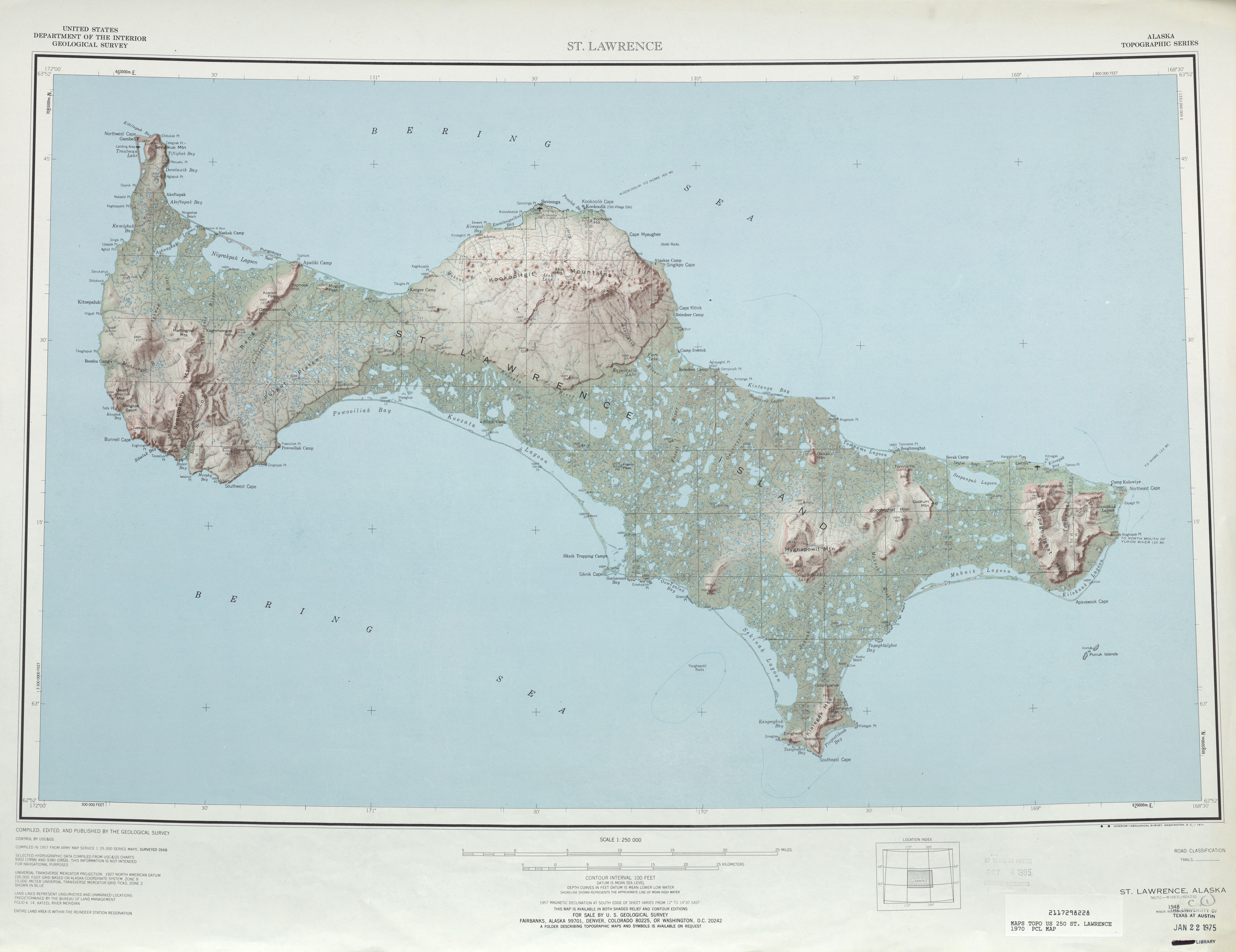
English: map sheet of Saint Lawrence Island, Alaska |
| Datum | |
| Boarne | http://www.lib.utexas.edu/maps/topo/250k/txu-pclmaps-topo-us-saint_lawrence-1970.jpg |
| Auteur | US Geological Survey |
| Oare ferzjes |
.jpg)
Lisinsje
This image is in the public domain in the United States because it only contains materials that originally came from the United States Geological Survey, an agency of the United States Department of the Interior. For more information, see the official USGS copyright policy.
|
Triemskiednis
Klik op in datum/tiid om it bestân te besjen sa't it op dat stuit wie.
| Datum/Tiid | Miniatuer | ôfmjittings | Meidogger | Opmerking | |
|---|---|---|---|---|---|
| lêste | 1 okt 2010, 23.45 | | 5.957 × 4.589 (4,29 MB) | Ratzer | {{Information |Description={{en|1=map sheet of Saint Lawrence Island, Alaska}} |Source=http://www.lib.utexas.edu/maps/topo/250k/txu-pclmaps-topo-us-saint_lawrence-1970.jpg |Author=US Geological Survey |Date=1970 |Permission= |other_versions= }} [[Categor |
Bestânsgebrûk
De neikommende side brûkt dit bestân:
Globaal bestânsgebrûk
De neikommende oare wiki's brûke dit bestân:
- Gebrûk op ar.wikipedia.org
- Gebrûk op be.wikipedia.org
- Gebrûk op bg.wikipedia.org
- Gebrûk op ca.wikipedia.org
- Gebrûk op ceb.wikipedia.org
- Gebrûk op cs.wikipedia.org
- Gebrûk op da.wikipedia.org
- Gebrûk op de.wikipedia.org
- Gebrûk op el.wikipedia.org
- Gebrûk op en.wikipedia.org
- Gebrûk op eo.wikipedia.org
- Gebrûk op es.wikipedia.org
- Gebrûk op eu.wikipedia.org
- Gebrûk op fa.wikipedia.org
- Gebrûk op fr.wikipedia.org
- Gebrûk op he.wikipedia.org
- Gebrûk op id.wikipedia.org
- Gebrûk op incubator.wikimedia.org
- Gebrûk op it.wikipedia.org
- Gebrûk op ja.wikipedia.org
- Gebrûk op no.wikipedia.org
- Gebrûk op pl.wikipedia.org
- Gebrûk op ru.wikipedia.org
- Gebrûk op sco.wikipedia.org
- Gebrûk op simple.wikipedia.org
- Gebrûk op th.wikipedia.org
- Gebrûk op www.wikidata.org
- Gebrûk op zh.wikipedia.org