
Ofbyld:Toronto map.png

Grutte fan dit proefbyld: 800 × 595 piksels. Oare resolúsjes: 320 × 238 piksels | 640 × 476 piksels | 1.024 × 761 piksels | 1.280 × 951 piksels | 1.500 × 1.115 piksels.
Oarspronklik bestân (1.500 × 1.115 pixels, bestânsgrutte: 703 KB, MIME-type: image/png)
|
| Beskriuwing |
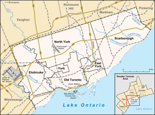
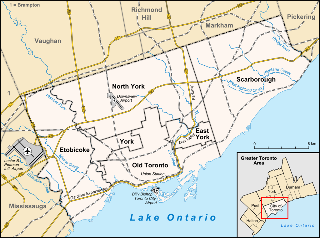
English: Map of Toronto
Français : Carte de Toronto
Deutsch: Karte von Toronto
Bahasa Indonesia: Peta kota Toronto |
| Datum | |
| Boarne |
own work, used:
|
| Auteur | Lencer |

|
This map has been made or improved in the German Kartenwerkstatt (Map Lab). You can propose maps to improve as well.
|
This file is licensed under the Creative Commons Attribution-Share Alike 3.0 Unported license.
- Fiel jo frij:
- te dielen – it wurk te kopiearjen, fersprieden en út te stjoeren
- te fermingen – it wurk oan te passen
- Under de neikommende betingsten:
- Nammefermelding – You must give appropriate credit, provide a link to the license, and indicate if changes were made. You may do so in any reasonable manner, but not in any way that suggests the licensor endorses you or your use.
- Lyk diele – If you remix, transform, or build upon the material, you must distribute your contributions under the same or compatible license as the original.
Triemskiednis
Klik op in datum/tiid om it bestân te besjen sa't it op dat stuit wie.
| Datum/Tiid | Miniatuer | ôfmjittings | Meidogger | Opmerking | |
|---|---|---|---|---|---|
| lêste | 3 apr 2012, 16.33 | | 1.500 × 1.115 (703 KB) | Lencer | + don river, minor adds of river names |
| 29 jun 2009, 17.59 |  | 1.500 × 1.115 (585 KB) | SimonP | correct minor error | |
| 29 jun 2009, 17.18 |  | 1.500 × 1.115 (585 KB) | SimonP | Corect East York border | |
| 18 jun 2009, 12.56 |  | 1.500 × 1.115 (677 KB) | Lencer | + don valley parkway | |
| 25 mrt 2009, 20.56 |  | 1.500 × 1.115 (673 KB) | Lencer | Int. => Intl. | |
| 18 mrt 2009, 14.19 |  | 1.500 × 1.115 (672 KB) | Lencer | Vaugahn -> Vaughan | |
| 10 mrt 2009, 08.54 |  | 1.500 × 1.115 (673 KB) | Lencer | fix Greater Toronto Area | |
| 9 mrt 2009, 14.29 |  | 1.500 × 1.115 (672 KB) | Lencer | + Minimap, some fixes | |
| 8 mrt 2009, 21.10 |  | 1.500 × 1.116 (628 KB) | Lencer | weitere Kartenelemente erg., Farben geändert | |
| 2 mrt 2009, 22.02 |  | 1.500 × 1.116 (475 KB) | Lencer | Fehlerhafte Grenze bei York |
Bestânsgebrûk
De neikommende side brûkt dit bestân:
Globaal bestânsgebrûk
De neikommende oare wiki's brûke dit bestân:
- Gebrûk op ar.wikipedia.org
- Gebrûk op ban.wikipedia.org
- Gebrûk op ceb.wikipedia.org
- Gebrûk op ckb.wikipedia.org
- Gebrûk op de.wikipedia.org
- Toronto
- Benutzer:Lencer
- Wikipedia:Exzellente Bilder/Karten und Satellitenbilder
- Liste der Ortsteile von Toronto
- Wikipedia:Kartenwerkstatt/Archiv/2009-03
- Wikipedia:Kandidaten für exzellente Bilder/Archiv2009/6
- Datei:Toronto map.png
- Toronto Fire Services
- Taber Hill
- Wikipedia:Kartenwerkstatt/Schaufenster
- Wikipedia:Exzellente Bilder/Kleine Bilder
- Gebrûk op en.wikipedia.org
- Toronto
- Rogers Centre
- Yonge–Dundas Square
- Billy Bishop Toronto City Airport
- Don River (Ontario)
- Forest Hill, Toronto
- Humber River (Ontario)
- The Annex
- Royal Ontario Museum
- Cabbagetown, Toronto
- Rosedale, Toronto
- The Beaches, Toronto
- High Park
- The Kingsway, Toronto
- Baby Point
- Bendale
- The Junction
- Little Italy, Toronto
- New Toronto
- Leslieville
- Kensington Market
- Scotiabank Arena
- Riverdale, Toronto
- Metropolitan Toronto
- Union Station (Toronto)
- Swansea, Toronto
- Parkdale, Toronto
- Rouge River (Ontario)
- Ontario Science Centre
- Black Creek Pioneer Village
- Agincourt, Toronto
Mear globaal gebrûk fan dit bestân besjen.