
Ofbyld:Topographic map of Zanzibar-en.svg

Size of this PNG preview of this SVG file: 416 × 599 piksels. Oare resolúsjes: 166 × 240 piksels | 333 × 480 piksels | 533 × 768 piksels | 711 × 1.024 piksels | 1.422 × 2.048 piksels | 420 × 605 piksels.
Oarspronklik bestân (SVG-bestân, nominaal 420 × 605 pixels, bestânsgrutte: 409 KB)
This W3C-unspecified vector image was created with Inkscape .
Gearfetting
| Beskriuwing |
|
| Datum | |
| Boarne |
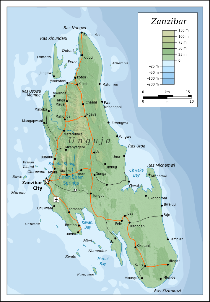
Self-made in Inkscape (renamed from Image:Topographic map of Zanzibar.svg). Roads, rivers and place names based on a public domain 1976 CIA map (from http://www.lib.utexas.edu/maps/tanzania.html) with some updates applied. Topography based on public domain SRTM data from NASA. Bathymetry per http://www.theissresearch.org/zanzibar/. |
| Auteur | Mysid |
| Oare ferzjes |
[]
|


|
This SVG file contains embedded text that can be translated into your language, using any capable SVG editor, text editor or the SVG Translate tool. For more information see: About translating SVG files. |
Lisinsje
I, the copyright holder of this work, hereby publish it under the following licenses:

|
Der wurdt tastimming jûn ta kopiearjen, fersprieden en/of wizigjen fan dit dokumint ûnder de betinksten fan de GNU-lisinsje foar iepen dokumintaasje, ferzje 1.2, as eltse lettere ferzje útjûn troch de Free Software Foundation; sûnder Ynfariante Seksjes, sûnder Omkaftteksten foar de Foarkante en sûnder Omkaftteksten foar de Efterkante. In kopy fan de lisinsje is opnaam yn de seksje "Text of the GNU Free Documentation License". |
This file is licensed under the Creative Commons Attribution-Share Alike 4.0 International, 3.0 Unported, 2.5 Generic, 2.0 Generic and 1.0 Generic license.
- Fiel jo frij:
- te dielen – it wurk te kopiearjen, fersprieden en út te stjoeren
- te fermingen – it wurk oan te passen
- Under de neikommende betingsten:
- Nammefermelding – You must give appropriate credit, provide a link to the license, and indicate if changes were made. You may do so in any reasonable manner, but not in any way that suggests the licensor endorses you or your use.
- Lyk diele – If you remix, transform, or build upon the material, you must distribute your contributions under the same or compatible license as the original.
You may select the license of your choice.
Triemskiednis
Klik op in datum/tiid om it bestân te besjen sa't it op dat stuit wie.
| Datum/Tiid | Miniatuer | ôfmjittings | Meidogger | Opmerking | |
|---|---|---|---|---|---|
| lêste | 20 jul 2010, 22.52 | | 420 × 605 (409 KB) | Mysid | cropping fail! |
| 20 jul 2010, 22.50 |  | 429 × 630 (409 KB) | Mysid | revised with relief shading and higher-grain topography | |
| 19 apr 2008, 13.01 |  | 400 × 601 (61 KB) | Bibi Saint-Pol | {{inkscape}} == {{int:filedesc}} == {{Information |Description= {{en|Topographic map of Zanzibar, Tanzania.}} {{fi|Sansibarin (Tansania) topografinen kartta.}} |Source=Self-made in Inkscape.<br/>Boundaries based on a public domain 1976 CIA map (from http: |
Bestânsgebrûk
De neikommende 3 siden brûke dit bestân:
Globaal bestânsgebrûk
De neikommende oare wiki's brûke dit bestân:
- Gebrûk op af.wikipedia.org
- Gebrûk op ar.wikipedia.org
- Gebrûk op bg.wikipedia.org
- Gebrûk op ca.wikipedia.org
- Gebrûk op ceb.wikipedia.org
- Gebrûk op cs.wikipedia.org
- Gebrûk op cy.wikipedia.org
- Gebrûk op da.wikipedia.org
- Gebrûk op de.wikipedia.org
- Gebrûk op de.wikivoyage.org
- Gebrûk op el.wikipedia.org
- Gebrûk op en.wikipedia.org
- Gebrûk op eo.wikipedia.org
- Gebrûk op es.wikipedia.org
- Gebrûk op eu.wikipedia.org
- Gebrûk op fr.wikipedia.org
- Gebrûk op gl.wikipedia.org
- Gebrûk op he.wikipedia.org
- Gebrûk op hr.wikipedia.org
- Gebrûk op hy.wikipedia.org
- Gebrûk op id.wikipedia.org
- Gebrûk op it.wikivoyage.org
- Gebrûk op ko.wikipedia.org
- Gebrûk op lt.wikipedia.org
- Gebrûk op mrj.wikipedia.org
- Gebrûk op nl.wikipedia.org
- Gebrûk op no.wikipedia.org
- Gebrûk op pl.wikipedia.org
- Gebrûk op pl.wiktionary.org
- Gebrûk op ru.wikipedia.org
- Gebrûk op sh.wikipedia.org
- Gebrûk op sn.wikipedia.org
- Gebrûk op sq.wikipedia.org
- Gebrûk op sv.wikipedia.org
- Gebrûk op uk.wikipedia.org
- Gebrûk op ur.wikipedia.org
- Gebrûk op vi.wikipedia.org
- Gebrûk op www.wikidata.org
Mear globaal gebrûk fan dit bestân besjen.