
Ofbyld:Taunus - Deutsche Mittelgebirge, Serie A-de.png

Oarspronklik bestân (2.300 × 1.500 pixels, bestânsgrutte: 5,05 MB, MIME-type: image/png)
Gearfetting
| Beskriuwing |
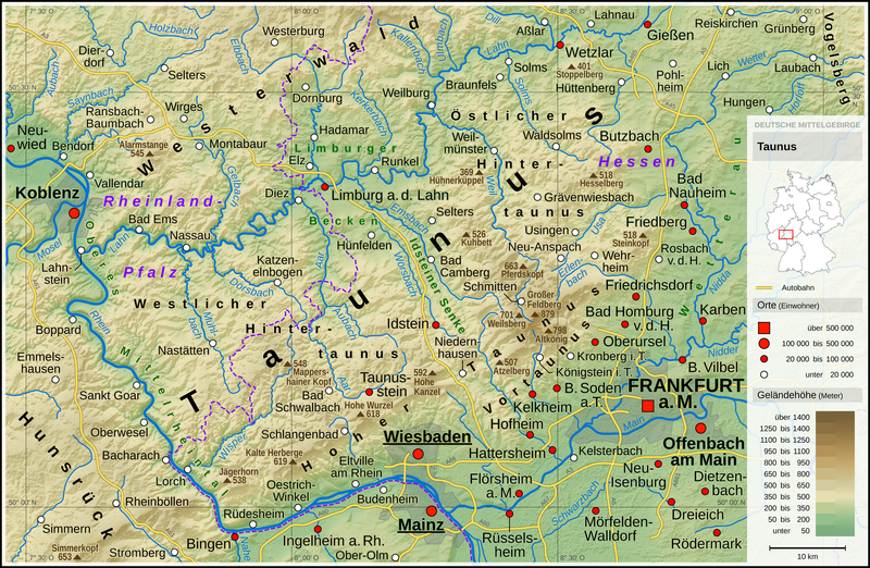
English: Topographic map of the Taunus
Deutsch: Topografische Karte des Taunus |
||||||||||||||||||
| Datum | |||||||||||||||||||
| Boarne |
Own work using: |
||||||||||||||||||
| Auteur | Thoroe | ||||||||||||||||||
| Oare ferzjes |
 Topographic maps of German low mountain ranges (A series)
This map series aims to show the major low mountain ranges of Germany in a uniform design. All maps are created on the same scale, and the background reliefs base upon the same color scheme. The reliefs are also available as separate files. You can find the making-of one of the maps in the German language Wikipedia (German only).
|
||||||||||||||||||


_-_Deutsche_Mittelgebirge,_Serie_A-de.png)
_-_Deutsche_Mittelgebirge,_Serie_A-de.png)
_-_Deutsche_Mittelgebirge,_Serie_A-de.png)
_-_Deutsche_Mittelgebirge,_Serie_A-de.png)
_-_Deutsche_Mittelgebirge,_Serie_A-de.png)
_-_Deutsche_Mittelgebirge,_Serie_A-de.png)
_-_Deutsche_Mittelgebirge,_Serie_A-de.png)
_-_Deutsche_Mittelgebirge,_Serie_A-de.png)
_-_Deutsche_Mittelgebirge,_Serie_A-de.png)
_-_Deutsche_Mittelgebirge,_Serie_A-de.png)
_-_Deutsche_Mittelgebirge,_Serie_A-de.png)
_-_Deutsche_Mittelgebirge,_Serie_A-de.png)
_-_Deutsche_Mittelgebirge,_Serie_A-de.png)
_-_Deutsche_Mittelgebirge,_Serie_A-de.png)
_-_Deutsche_Mittelgebirge,_Serie_A-de.png)
_-_Deutsche_Mittelgebirge,_Serie_A-de.png)
_-_Deutsche_Mittelgebirge,_Serie_A-de.png)
_-_Deutsche_Mittelgebirge,_Serie_A-de.png)
_-_Deutsche_Mittelgebirge,_Serie_A-de.png)
_-_Deutsche_Mittelgebirge,_Serie_A-de.png)
_-_Deutsche_Mittelgebirge,_Serie_A-de.png)
_-_Deutsche_Mittelgebirge,_Serie_A-de.png)
_-_Deutsche_Mittelgebirge,_Serie_A-de.png)
_-_Deutsche_Mittelgebirge,_Serie_A-de.png)
_-_Deutsche_Mittelgebirge,_Serie_A-de.png)
_-_Deutsche_Mittelgebirge,_Serie_A-de.png)
_-_Deutsche_Mittelgebirge,_Serie_A-de.png)
_-_Deutsche_Mittelgebirge,_Serie_A-de.png)
_-_Deutsche_Mittelgebirge,_Serie_A-de.png)
_-_Deutsche_Mittelgebirge,_Serie_A-de.png)
_-_Deutsche_Mittelgebirge,_Serie_A-de.png)
_-_Deutsche_Mittelgebirge,_Serie_A-de.png)
| This work contains information from OpenStreetMap, which is made available under the Open Database License (ODbL).
The ODbL does not require any particular license for maps produced from ODbL data. Prior to 1 August 2020, map tiles produced by the OpenStreetMap Foundation were licensed under the CC-BY-SA-2.0 license. Maps produced by other people may be subject to other licences. |

|
This map has been made or improved in the German Kartenwerkstatt (Map Lab). You can propose maps to improve as well.
|
Lisinsje
- Fiel jo frij:
- te dielen – it wurk te kopiearjen, fersprieden en út te stjoeren
- te fermingen – it wurk oan te passen
- Under de neikommende betingsten:
- Nammefermelding – You must give appropriate credit, provide a link to the license, and indicate if changes were made. You may do so in any reasonable manner, but not in any way that suggests the licensor endorses you or your use.
- Lyk diele – If you remix, transform, or build upon the material, you must distribute your contributions under the same or compatible license as the original.
| Annotations | This image is annotated: View the annotations at Commons |
Triemskiednis
Klik op in datum/tiid om it bestân te besjen sa't it op dat stuit wie.
| Datum/Tiid | Miniatuer | ôfmjittings | Meidogger | Opmerking | |
|---|---|---|---|---|---|
| lêste | 13 jan 2017, 01.16 | | 2.300 × 1.500 (5,05 MB) | Thoroe | City size fixes |
| 5 jan 2017, 12.09 |  | 2.300 × 1.500 (5,05 MB) | Thoroe | minor additions | |
| 5 jan 2017, 00.59 |  | 2.300 × 1.500 (5,05 MB) | Thoroe | some fixes | |
| 4 jan 2017, 13.00 |  | 2.300 × 1.500 (5,03 MB) | Thoroe | {{Information |Description ={{en|1=Topographic map of the Taunus}} {{de|1=Topografische Karte des Taunus}} |Source ={{Own using}} *[http://gmt.soest.hawaii.edu Generic Mapping Tools (GMT)] with [http://dds.cr.us... |
Bestânsgebrûk
De neikommende side brûkt dit bestân:
Globaal bestânsgebrûk
De neikommende oare wiki's brûke dit bestân:
- Gebrûk op bg.wikipedia.org
- Gebrûk op br.wikipedia.org
- Gebrûk op de.wikipedia.org
- Taunus
- Benutzer:Sebastian Wallroth
- Einrich
- Vordertaunus
- Benutzer:Kogge
- Limburger Becken
- Hintertaunus
- Liste von Bergen und Erhebungen des Taunus
- Hoher Taunus
- Benutzer:Thoroe
- Wikipedia:Kartenwerkstatt
- Diskussion:Schneekoppe/Archiv
- Benutzerin:Dritte von links
- Benutzer:Geheimnisenthüller/Bildergalerie
- Wikipedia:Kartenwerkstatt/Karte des Tages/Galerie
- Benutzer:Sebastian Wallroth/surprise
- Wikipedia:Kartenwerkstatt/Archiv/2017-01
- Benutzer:Jonaes02/B/Bilder
- Benutzer:Thoroe/Making of Thüringer Wald
- Gebrûk op en.wikipedia.org
- Gebrûk op en.wikivoyage.org
- Gebrûk op eo.wikipedia.org
- Gebrûk op es.wikipedia.org
- Gebrûk op fa.wikipedia.org
- Gebrûk op fr.wikipedia.org
- Gebrûk op li.wikipedia.org
- Gebrûk op nl.wikipedia.org
- Gebrûk op no.wikipedia.org
- Gebrûk op pt.wikipedia.org
- Gebrûk op sw.wikipedia.org
- Gebrûk op www.wikidata.org