
Ofbyld:Sydney Harbour Bridge night.jpg

Grutte fan dit proefbyld: 800 × 200 piksels. Oare resolúsjes: 320 × 80 piksels | 640 × 160 piksels | 1.024 × 256 piksels | 1.280 × 320 piksels | 2.560 × 639 piksels | 13.742 × 3.431 piksels.
Oarspronklik bestân (13.742 × 3.431 pixels, bestânsgrutte: 10,9 MB, MIME-type: image/jpeg)
Gearfetting
| Beskriuwing |
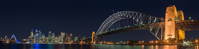
English: A panoramic view of the Sydney Harbour Bridge at night, as seen from the North Shore suburb of Kirribilli.
Français : Le Harbour Bridge vu depuis Kirribilli, une commune de la banlieue de Sydney sur la rive nord.
中文:从克里比利北岸拍摄的悉尼港大桥。 |
| Datum | Taken on 15 juny 2005 |
| Boarne | taken by Diliff |
| Auteur | Diliff |
| Tastimming (Reusing this file) |
Summary:In using this image or any subsequent derivatives of it, you are required to release the image under the same license. As such, any reproduction of this image, in any medium, must appear with a copy of, or full URL of the license.Attribution of this image to the author (DAVID ILIFF) is also required, preferably in a prominent location near the image.No other conditions may be added to, or removed from this license without the permission of the author and copyright holder.Suggested attribution: "Photo by DAVID ILIFF. License: CC BY-SA 3.0"Please review the full license requirements carefully before using this image. If you would like to clarify the terms of the license or negotiate less restrictive commercial licensing outside of the bounds of GFDL/CC-BY-SA, please contact me by email, or if you don't have a Wikipedia account you can either leave a message on my talk page with your contact details and your request, or you can contact me on Facebook. Please also send a 'friend request' to ensure that I am aware of your message. |
| Oare ferzjes |
copied from en.wikipedia |
| Camera location | | View this and other nearby images on: OpenStreetMap |
|---|
Lisinsje
I, the copyright holder of this work, hereby publish it under the following licenses:
This file is licensed under the Creative Commons Attribution-Share Alike 3.0 Unported license.
- Fiel jo frij:
- te dielen – it wurk te kopiearjen, fersprieden en út te stjoeren
- te fermingen – it wurk oan te passen
- Under de neikommende betingsten:
- Nammefermelding – You must give appropriate credit, provide a link to the license, and indicate if changes were made. You may do so in any reasonable manner, but not in any way that suggests the licensor endorses you or your use.
- Lyk diele – If you remix, transform, or build upon the material, you must distribute your contributions under the same or compatible license as the original.

|
Der wurdt tastimming jûn ta kopiearjen, fersprieden en/of wizigjen fan dit dokumint ûnder de betinksten fan de GNU-lisinsje foar iepen dokumintaasje, ferzje 1.2, as eltse lettere ferzje útjûn troch de Free Software Foundation; sûnder Ynfariante Seksjes, sûnder Omkaftteksten foar de Foarkante en sûnder Omkaftteksten foar de Efterkante. In kopy fan de lisinsje is opnaam yn de seksje "Text of the GNU Free Documentation License". |
You may select the license of your choice.
Assessment
|

This image was selected as picture of the day on Wikimedia Commons for 5 October 2006. It was captioned as follows: English: Sydney Harbour Bridge Other languages:
Cymraeg: Pont Harbwr Sydney Deutsch: Hafenbrücke in Sydney English: Sydney Harbour Bridge Español: Puente del puerto de Sídney, Australia. Magyar: A Sydney Harbour-híd Norsk nynorsk: Sydney Harbour Bridge Polski: Most portowy w Sydney (Harbour Bridge) Português: Ponte do porto de Sydney Slovenščina: Sydneyjski pristaniški most Svenska: Sydney Harbour Bridge Русский: Мост в гавани (Harbour Bridge), Сидней 中文: 悉尼港大桥 العربية : جسر ميناء مدينة سيدني |
| Annotations | This image is annotated: View the annotations at Commons |
Triemskiednis
Klik op in datum/tiid om it bestân te besjen sa't it op dat stuit wie.
| Datum/Tiid | Miniatuer | ôfmjittings | Meidogger | Opmerking | |
|---|---|---|---|---|---|
| lêste | 19 jun 2013, 16.03 | 13.742 × 3.431 (10,9 MB) | Diliff | reprocessed... different colour balance, slightly wider view. | |
| 29 nov 2005, 05.05 | 6.412 × 1.445 (2,43 MB) | Thuresson | Sydney Harbour Bridge as seen from the North Shore suburb of Kirribilli. Taken on the 15th of June, 2005. Image history at en: (del) (cur) 16:46, 10 September 2005 . . Diliff . . 6412x1445 (2548430 bytes) (del) (rev) 08:38, 28 Augus |
Bestânsgebrûk
De neikommende side brûkt dit bestân:
Globaal bestânsgebrûk
De neikommende oare wiki's brûke dit bestân:
- Gebrûk op af.wikipedia.org
- Gebrûk op ar.wikipedia.org
- Gebrûk op ba.wikipedia.org
- Gebrûk op be-tarask.wikipedia.org
- Gebrûk op be.wikipedia.org
- Gebrûk op bg.wikipedia.org
- Gebrûk op bn.wikipedia.org
- Gebrûk op ca.wikipedia.org
- Gebrûk op cs.wikipedia.org
- Gebrûk op da.wikipedia.org
- Gebrûk op de.wikipedia.org
- Wikipedia:Kandidaten für exzellente Bilder/Archiv2006/17
- Datei:Sydney Harbour Bridge night.jpg
- Portal:Planung/Bilder Galerie
- Benutzer:Symbiosus/Gallerie der Lieblingsbilder
- Wikipedia:Exzellente Bilder/Kunst und Kultur
- Benutzer:Mikullovci11/Work/Sonstige Fotos
- Benutzer:Der Wolf im Wald/Lieblingsbilder
- Benutzer:HerrSonderbar/Rubrik Orte
- Gebrûk op diq.wikipedia.org
- Gebrûk op en.wikipedia.org
- Sydney Harbour Bridge
- Panoramic photography
- Urban area
- User talk:Chowells
- Wikipedia:Picture of the day/December 2005
- Wikipedia:Featured pictures thumbs/03
- Wikipedia:Today's second feature/December 2005
- Wikipedia:Featured picture candidates/Sydney Harbour Bridge
- Wikipedia:Featured picture candidates/October-2005
- User:Diliff
- Wikipedia:Wikipedia Signpost/2005-10-24/Features and admins
- Wikipedia:Australian Wikipedians' notice board/Welcome
- Wikipedia:WikiProject Bridges and Tunnels
- User:Cyde/Featured pictures
- Wikipedia:Picture of the day/December 25, 2005
- Wikipedia:POTD/December 25, 2005
- Wikipedia:Today's second feature/December 25, 2005
- Wikipedia:Featured picture candidates/February-2006
- Wikipedia:Featured picture candidates/MarinaBay
- Wikipedia:Featured picture candidates/Eastrock02
- Wikipedia:Featured picture candidates/April-2006
- Wikipedia:Featured picture candidates/Golden Bauhinia
Mear globaal gebrûk fan dit bestân besjen.