
Ofbyld:Sumatra Volcanoes.png
Gjin hegere resolúsje beskikber.
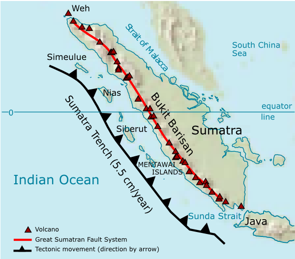
Sumatra_Volcanoes.png (600 × 527 pixels, bestânsgrutte: 141 KB, MIME-type: image/png)
| Beskriuwing | Volcanoes on Sumatra island. See en:List of volcanoes in Indonesia. | ||||||||
| Datum | |||||||||
| Boarne | Eigen wurk | ||||||||
| Auteur | User:Indon (myself) | ||||||||
| Tastimming (Reusing this file) |
I, the copyright holder of this work, hereby publish it under the following licenses:
You may select the license of your choice. |

Source of maps:
- Base map is a truncated public domain image: Image:Southeast asia.svg.
- Geological trench system is taken from Simoes, M., et al. (2004), The Sumatra subduction zone: A case for a locked fault zone extending into the mantle, J. of Geophysical Research, 109. DOI: 10.1029/2003JB002958.
- Volcanoes location was traced from en:Google Earth system.
Triemskiednis
Klik op in datum/tiid om it bestân te besjen sa't it op dat stuit wie.
| Datum/Tiid | Miniatuer | ôfmjittings | Meidogger | Opmerking | |
|---|---|---|---|---|---|
| lêste | 28 des 2006, 03.35 | | 600 × 527 (141 KB) | Indon~commonswiki | {{Information |Description=Volcanoes on Sumatra island. See en:List of volcanoes in Indonesia. |Source=own work |Date=2006 |Author=User:Indon (myself) |Permission={{GFDL-self}} |other_versions= }} Source of maps: # Base map is a truncated public |
Bestânsgebrûk
De neikommende side brûkt dit bestân:
Globaal bestânsgebrûk
De neikommende oare wiki's brûke dit bestân:
- Gebrûk op ar.wikipedia.org
- Gebrûk op arz.wikipedia.org
- Gebrûk op ast.wikipedia.org
- Gebrûk op as.wikipedia.org
- Gebrûk op bg.wikipedia.org
- Gebrûk op bs.wikipedia.org
- Gebrûk op ca.wikipedia.org
- Gebrûk op ceb.wikipedia.org
- Gebrûk op ckb.wikipedia.org
- Gebrûk op cs.wikipedia.org
- Gebrûk op da.wikipedia.org
- Gebrûk op de.wikipedia.org
- Gebrûk op en.wikipedia.org
- Gebrûk op eo.wikipedia.org
- Gebrûk op es.wikipedia.org
- Gebrûk op fa.wikipedia.org
- Gebrûk op fi.wikipedia.org
- Gebrûk op fo.wikipedia.org
- Gebrûk op frr.wikipedia.org
- Gebrûk op fr.wikipedia.org
- Gebrûk op ha.wikipedia.org
- Gebrûk op hi.wikipedia.org
- Gebrûk op id.wikipedia.org
- Gebrûk op it.wikipedia.org
- Gebrûk op ja.wikipedia.org
Mear globaal gebrûk fan dit bestân besjen.