
Ofbyld:Semmering Railway 2013.jpg
Grutte fan dit proefbyld: 800 × 533 piksels. Oare resolúsjes: 320 × 213 piksels | 640 × 427 piksels | 1.024 × 683 piksels | 1.500 × 1.000 piksels.
Oarspronklik bestân (1.500 × 1.000 pixels, bestânsgrutte: 1,65 MB, MIME-type: image/jpeg)
Gearfetting
| Beskriuwing |
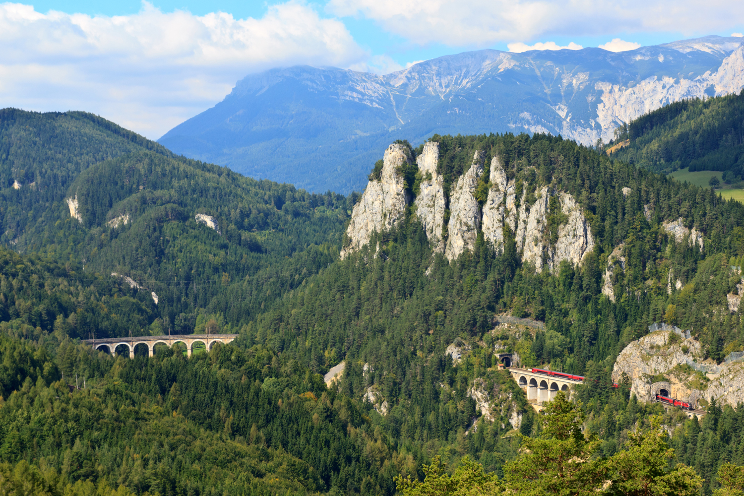
English: Semmering Railway: Visible (from left to right) are the Kalte Rinne-viaduct, the Polleros-tunnel beneath the Pollereswand, the Krausel-Klause-viaduct and the small Krausel tunnel, trough which a Railjet train is passing. The Rax Alp is in the background. This scenery is known as the 20-Schilling view.
Deutsch: Semmeringbahn: Sichtbar sind (von links nach rechts) das Viadukt über die Kalte Rinne, der Polleros-Tunnel unterhalb der Pollereswand, das Krausel-Klause-Viadukt sowei der kleiner Krausel-Tunnel, den gerade ein Railjet durchfährt. Im Hintergrund die Raxalpe. Diese Ansicht ist auch als "20-Schilling-Blick" bekannt.
|
| Datum | |
| Boarne | Eigen wurk |
| Auteur | H. Raab (User:Vesta) |
| Camera location | | View this and other nearby images on: OpenStreetMap |
|---|

|
Dizze ôfbylding is heechladen yn it ramt fan Wiki Loves Monuments 2013.
|
Lisinsje
I, the copyright holder of this work, hereby publish it under the following license:
This file is licensed under the Creative Commons Attribution-Share Alike 3.0 Unported license.
- Fiel jo frij:
- te dielen – it wurk te kopiearjen, fersprieden en út te stjoeren
- te fermingen – it wurk oan te passen
- Under de neikommende betingsten:
- Nammefermelding – You must give appropriate credit, provide a link to the license, and indicate if changes were made. You may do so in any reasonable manner, but not in any way that suggests the licensor endorses you or your use.
- Lyk diele – If you remix, transform, or build upon the material, you must distribute your contributions under the same or compatible license as the original.
Triemskiednis
Klik op in datum/tiid om it bestân te besjen sa't it op dat stuit wie.
| Datum/Tiid | Miniatuer | ôfmjittings | Meidogger | Opmerking | |
|---|---|---|---|---|---|
| lêste | 8 sep 2013, 15.47 | | 1.500 × 1.000 (1,65 MB) | Vesta~commonswiki | User created page with UploadWizard |
Bestânsgebrûk
De neikommende side brûkt dit bestân:
Globaal bestânsgebrûk
De neikommende oare wiki's brûke dit bestân:
- Gebrûk op af.wikipedia.org
- Gebrûk op cs.wikipedia.org
- Gebrûk op de.wikipedia.org
- Gebrûk op gl.wikipedia.org
- Gebrûk op hy.wikipedia.org
- Gebrûk op ja.wikipedia.org
- Gebrûk op kn.wikipedia.org
- Gebrûk op no.wikipedia.org
- Gebrûk op sl.wikipedia.org