
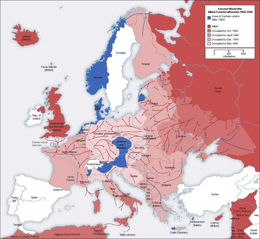
Ofbyld:Second world war europe 1943-1945 map en.png
Grutte fan dit proefbyld: 654 × 600 piksels. Oare resolúsjes: 262 × 240 piksels | 523 × 480 piksels | 837 × 768 piksels | 1.090 × 1.000 piksels.
Oarspronklik bestân (1.090 × 1.000 pixels, bestânsgrutte: 264 KB, MIME-type: image/png)
I, the copyright holder of this work, hereby publish it under the following licenses:
| This file is licensed under the Creative Commons Attribution-Share Alike 3.0 Unported license. | ||
| ||
| This licensing tag was added to this file as part of the GFDL licensing update. |

|
Der wurdt tastimming jûn ta kopiearjen, fersprieden en/of wizigjen fan dit dokumint ûnder de betinksten fan de GNU-lisinsje foar iepen dokumintaasje, ferzje 1.2, as eltse lettere ferzje útjûn troch de Free Software Foundation; sûnder Ynfariante Seksjes, sûnder Omkaftteksten foar de Foarkante en sûnder Omkaftteksten foar de Efterkante. In kopy fan de lisinsje is opnaam yn de seksje "Text of the GNU Free Documentation License". |
You may select the license of your choice.
Original upload log
This image is a derivative work of the following images:
- File:Second_world_war_europe_1943-1945_map_de.png licensed with Cc-by-sa-3.0-migrated, GFDL
- 2005-08-22T13:32:49Z Rony 1090x1000 (199724 Bytes)
Uploaded with derivativeFX
Triemskiednis
Klik op in datum/tiid om it bestân te besjen sa't it op dat stuit wie.
| Datum/Tiid | Miniatuer | ôfmjittings | Meidogger | Opmerking | |
|---|---|---|---|---|---|
| lêste | 25 okt 2021, 00.51 | | 1.090 × 1.000 (264 KB) | Rebelbear | Reverted to version as of 22:20, 24 October 2021 (UTC) |
| 25 okt 2021, 00.43 |  | 1.090 × 1.000 (130 KB) | Rebelbear | Interestingly enough, the Channel Islands were still under German occupation at the end of the war (sorry, first upload did not work) | |
| 25 okt 2021, 00.20 |  | 1.090 × 1.000 (264 KB) | Rebelbear | Interestingly enough, the Channel Islands were still under German occupation at the end of the war | |
| 20 nov 2019, 19.24 |  | 1.090 × 1.000 (115 KB) | Claude Zygiel | Cosmetic (differenciate shorelines, borders, demarcation lines) | |
| 2 des 2015, 07.46 |  | 1.090 × 1.000 (108 KB) | Rhadamante | I don't know if there is a problem for color blinds with this version, but hte current one is totally unreadable | |
| 22 mai 2012, 19.18 |  | 1.088 × 998 (286 KB) | DIREKTOR | Colours | |
| 21 aug 2010, 12.46 |  | 1.090 × 1.000 (108 KB) | Jarry1250 | {{Information |Description=* Description: Second world war europe 1943-1945, map , relabelled into English * Original source: Own map, based on the maps of the [http://www.lib.utexas.edu/maps/ University of Texas Libraries] * Original author: [[User:San |
Bestânsgebrûk
De neikommende side brûkt dit bestân:
Globaal bestânsgebrûk
De neikommende oare wiki's brûke dit bestân:
- Gebrûk op ar.wikipedia.org
- Gebrûk op be.wikipedia.org
- Gebrûk op bg.wikipedia.org
- Gebrûk op ca.wikipedia.org
- Gebrûk op cs.wikipedia.org
- Gebrûk op en.wikipedia.org
- Gebrûk op es.wikipedia.org
- Gebrûk op eu.wikipedia.org
- Gebrûk op fa.wikipedia.org
- Gebrûk op fi.wikipedia.org
- Gebrûk op fr.wikipedia.org
- Gebrûk op ja.wikipedia.org
- Gebrûk op ko.wikipedia.org
- Gebrûk op no.wikipedia.org
- Gebrûk op pnb.wikipedia.org
- Gebrûk op pt.wikipedia.org
- Gebrûk op ru.wikipedia.org
- Gebrûk op sv.wikipedia.org
- Gebrûk op ta.wikipedia.org
- Gebrûk op tr.wikipedia.org
- Gebrûk op uk.wikipedia.org
- Gebrûk op ur.wikipedia.org