
Ofbyld:ScotlandTradNumbered.png
Gjin hegere resolúsje beskikber.
ScotlandTradNumbered.png (400 × 504 pixels, bestânsgrutte: 104 KB, MIME-type: image/png)

|
This locator map image could be re-created using vector graphics as an SVG file. This has several advantages; see Commons:Media for cleanup for more information. If an SVG form of this image is available, please upload it and afterwards replace this template with
{{vector version available|new image name}}.
It is recommended to name the SVG file “ScotlandTradNumbered.svg”—then the template Vector version available (or Vva) does not need the new image name parameter. |
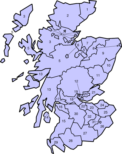
Traditional counties of Scotland
Slightly edited version of a map originally drawn by Morwen
- Caithness
- Sutherland
- Ross-shire
- Cromartyshire
- Inverness-shire
- Nairnshire
- Morayshire
- Banffshire
- Aberdeenshire
- Kincardineshire
- Angus
- Perthshire
- Argyll
- Bute
- Ayrshire
- Renfrewshire
- Dunbartonshire
- Stirlingshire
- Clackmannanshire
- Kinross-shire
- Fife
- West Lothian
- Mid Lothian
- East Lothian
- Berwickshire
- Roxburghshire
- Dumfriesshire
- Kirkcudbrightshire
- Wigtownshire
- Lanarkshire
- Selkirkshire
- Peeblesshire

|
Der wurdt tastimming jûn ta kopiearjen, fersprieden en/of wizigjen fan dit dokumint ûnder de betinksten fan de GNU-lisinsje foar iepen dokumintaasje, ferzje 1.2, as eltse lettere ferzje útjûn troch de Free Software Foundation; sûnder Ynfariante Seksjes, sûnder Omkaftteksten foar de Foarkante en sûnder Omkaftteksten foar de Efterkante. In kopy fan de lisinsje is opnaam yn de seksje "Text of the GNU Free Documentation License". |
| This file is licensed under the Creative Commons Attribution-Share Alike 3.0 Unported license. | ||
| ||
| This licensing tag was added to this file as part of the GFDL licensing update. |
Triemskiednis
Klik op in datum/tiid om it bestân te besjen sa't it op dat stuit wie.
| Datum/Tiid | Miniatuer | ôfmjittings | Meidogger | Opmerking | |
|---|---|---|---|---|---|
| lêste | 29 mai 2005, 21.29 | | 400 × 504 (104 KB) | Bastique | Replaces image in other wikis. From en.wiki {{GFDL}} |
| 18 mai 2005, 21.05 |  | 420 × 520 (13 KB) | Voyager | Traditional counties of Scotland Slightly edited version of a map originally drawn by Morwen {{GFDL}} Category:Maps of Scottish traditional counties |
Bestânsgebrûk
De neikommende side brûkt dit bestân:
Globaal bestânsgebrûk
De neikommende oare wiki's brûke dit bestân:
- Gebrûk op br.wikipedia.org
- Gebrûk op cs.wikipedia.org
- Gebrûk op de.wikipedia.org
- Gebrûk op en.wikipedia.org
- Gebrûk op fr.wikipedia.org
- Gebrûk op ga.wikipedia.org
- Gebrûk op gd.wikipedia.org
- Gebrûk op hy.wikipedia.org
- Gebrûk op it.wikipedia.org
- Gebrûk op ja.wikipedia.org
- Gebrûk op nl.wikipedia.org
- Gebrûk op nn.wikipedia.org
- Gebrûk op no.wikipedia.org
- Gebrûk op pt.wikipedia.org
- Gebrûk op sco.wikipedia.org
- Gebrûk op sh.wikipedia.org
- Gebrûk op sv.wikipedia.org
- Gebrûk op zh.wikipedia.org