
Ofbyld:Republic of Venice 1789.svg

Size of this PNG preview of this SVG file: 450 × 456 piksels. Oare resolúsjes: 237 × 240 piksels | 474 × 480 piksels | 758 × 768 piksels | 1.011 × 1.024 piksels | 2.021 × 2.048 piksels.
Oarspronklik bestân (SVG-bestân, nominaal 450 × 456 pixels, bestânsgrutte: 927 KB)
Gearfetting


.svg)
.svg)
.svg)
.svg)
.svg)


.svg)
.svg)
.svg)


.png)
.png)


.svg)


.svg)

.svg)


.svg)
.svg)
.svg)
.svg)


.svg)
.png)


.svg)


.svg)
.svg)


.svg)


.svg)


.svg)
.svg)
.svg)
.svg)
.svg)
.svg)
.svg)
_cropped.svg)
.svg)
.svg)
.svg)
.svg)
.svg)
.svg)
.svg)
.svg)
.svg)
.svg)
.svg)
.svg)
.svg)
.svg)
.svg)
.svg)
.svg)
.svg)
.svg)
.svg)
.svg)
.svg)
.svg)
.svg)
.svg)
.svg)
.svg)
.svg)
.svg)
.svg)
.svg)
.svg)
.svg)
.svg)
.svg)
.svg)
.svg)
.svg)
.svg)
.svg)
.svg)
.svg)
.svg)
.svg)
.svg)
Lisinsje
I, the copyright holder of this work, hereby publish it under the following license:
This file is licensed under the Creative Commons Attribution-Share Alike 3.0 Unported license.
- Fiel jo frij:
- te dielen – it wurk te kopiearjen, fersprieden en út te stjoeren
- te fermingen – it wurk oan te passen
- Under de neikommende betingsten:
- Nammefermelding – You must give appropriate credit, provide a link to the license, and indicate if changes were made. You may do so in any reasonable manner, but not in any way that suggests the licensor endorses you or your use.
- Lyk diele – If you remix, transform, or build upon the material, you must distribute your contributions under the same or compatible license as the original.
Original upload log
This image is a derivative work of the following images:
- File:Europe_1789.svg licensed with Cc-by-sa-3.0
- 2013-04-14T03:44:26Z Alphathon 450x456 (858577 Bytes) Corrected some errors in northern Italy
- 2013-04-14T01:38:01Z Alphathon 450x456 (853881 Bytes) tweaked again
- 2013-04-14T01:36:10Z Alphathon 450x456 (853881 Bytes) Tweaked Holy Roman Empire border style
- 2013-04-14T01:33:26Z Alphathon 450x456 (853857 Bytes) == {{int:filedesc}} == {{Information |Description={{en|A blank Map of Europe circa 1789. This map also includes a border for the [[:en:Holy Roman Empire|Holy Roman Empire]]. Since there are so many small German states, they h
Uploaded with derivativeFX
Triemskiednis
Klik op in datum/tiid om it bestân te besjen sa't it op dat stuit wie.
| Datum/Tiid | Miniatuer | ôfmjittings | Meidogger | Opmerking | |
|---|---|---|---|---|---|
| lêste | 27 nov 2021, 00.20 | | 450 × 456 (927 KB) | Cplakidas | Fixing Venetian Albania, adding Cythera to Venice |
| 17 okt 2021, 09.55 |  | 450 × 456 (803 KB) | Fenn-O-maniC | Fixed the Russo-Swedish border to match the Treaty of Åbo of 1743 | |
| 27 feb 2020, 11.23 |  | 450 × 456 (821 KB) | Facquis | Clear map | |
| 18 apr 2013, 19.16 |  | 450 × 456 (820 KB) | Alphathon | Various fixes | |
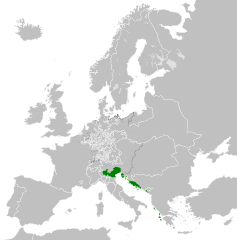
| 14 apr 2013, 05.54 |  | 450 × 456 (802 KB) | Alphathon | == {{int:filedesc}} == {{Information |Description={{en|A map of the Republic of Venice circa 1789.}}{{de|Eine Landkarte die Republik Venedig c. 1989.}} |Source={{Derived from|Europe_1789.svg|display=5... |
Bestânsgebrûk
De neikommende side brûkt dit bestân:
Globaal bestânsgebrûk
De neikommende oare wiki's brûke dit bestân:
- Gebrûk op azb.wikipedia.org
- Gebrûk op bg.wikipedia.org
- Gebrûk op ca.wikipedia.org
- Gebrûk op ckb.wikipedia.org
- Gebrûk op cs.wikipedia.org
- Gebrûk op de.wikipedia.org
- Gebrûk op el.wikipedia.org
- Gebrûk op en.wikipedia.org
- Gebrûk op eu.wikipedia.org
- Gebrûk op fa.wikipedia.org
- Gebrûk op he.wikipedia.org
- Gebrûk op hi.wikipedia.org
- Gebrûk op hr.wikipedia.org
- Gebrûk op it.wikipedia.org
- Gebrûk op ko.wikipedia.org
- Gebrûk op lfn.wikipedia.org
- Gebrûk op lij.wikipedia.org
- Gebrûk op lmo.wikipedia.org
- Gebrûk op mk.wikipedia.org
- Gebrûk op ml.wikipedia.org
- Gebrûk op ms.wikipedia.org
- Gebrûk op pl.wikipedia.org
- Gebrûk op pt.wikipedia.org
- Gebrûk op rue.wikipedia.org
- Gebrûk op ru.wikipedia.org
- Gebrûk op sk.wikipedia.org
- Gebrûk op szl.wikipedia.org
- Gebrûk op tr.wikipedia.org
- Gebrûk op uk.wikipedia.org
- Gebrûk op zh.wikipedia.org