
Ofbyld:Pineridgereservationmap.png
Gjin hegere resolúsje beskikber.
Pineridgereservationmap.png (493 × 379 pixels, bestânsgrutte: 71 KB, MIME-type: image/png)

|
This map image could be re-created using vector graphics as an SVG file. This has several advantages; see Commons:Media for cleanup for more information. If an SVG form of this image is available, please upload it and afterwards replace this template with
{{vector version available|new image name}}.
It is recommended to name the SVG file “Pineridgereservationmap.svg”—then the template Vector version available (or Vva) does not need the new image name parameter. |
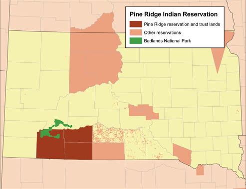
| Beskriuwing | Map of the Pine Ridge Indian Reservation. |
| Datum | |
| Boarne | Eigen wurk (Original text: Self-made using the National Atlas.) |
| Auteur | Kmusser |
Lisinsje
Kmusser, the copyright holder of this work, hereby publishes it under the following license:
This file is licensed under the Creative Commons Attribution-Share Alike 2.5 Generic license.
Nammefermelding: Kmusser
- Fiel jo frij:
- te dielen – it wurk te kopiearjen, fersprieden en út te stjoeren
- te fermingen – it wurk oan te passen
- Under de neikommende betingsten:
- Nammefermelding – You must give appropriate credit, provide a link to the license, and indicate if changes were made. You may do so in any reasonable manner, but not in any way that suggests the licensor endorses you or your use.
- Lyk diele – If you remix, transform, or build upon the material, you must distribute your contributions under the same or compatible license as the original.
Triemskiednis
Klik op in datum/tiid om it bestân te besjen sa't it op dat stuit wie.
| Datum/Tiid | Miniatuer | ôfmjittings | Meidogger | Opmerking | |
|---|---|---|---|---|---|
| lêste | 6 nov 2019, 23.09 | | 493 × 379 (71 KB) | Kmusser | crop and add the rest of Bennett county |
| 19 mrt 2008, 19.57 |  | 500 × 387 (82 KB) | Kmusser | added Badlands | |
| 19 mrt 2008, 19.43 |  | 500 × 389 (79 KB) | Kmusser | {{Information |Description=Map of the Pine Ridge Indian Reservation. |Source=Self-made using the National Atlas. |Date=March 19,2008 |Author= Kmusser |Permi |
Bestânsgebrûk
Der binne gjin siden dy't dit bestân brûke.
Globaal bestânsgebrûk
De neikommende oare wiki's brûke dit bestân:
- Gebrûk op ar.wikipedia.org
- Gebrûk op ca.wikipedia.org
- Gebrûk op cs.wikipedia.org
- Gebrûk op de.wikipedia.org
- Gebrûk op en.wikipedia.org
- Gebrûk op eo.wikipedia.org
- Gebrûk op fr.wikipedia.org
- Gebrûk op gl.wikipedia.org
- Gebrûk op nl.wikipedia.org
- Gebrûk op pl.wikipedia.org
- Gebrûk op uk.wikipedia.org
- Gebrûk op www.wikidata.org