
Ofbyld:OxfordshireOxford.png
Gjin hegere resolúsje beskikber.
OxfordshireOxford.png (200 × 267 pixels, bestânsgrutte: 17 KB, MIME-type: image/png)
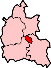
Oxford in Oxfordshire
Created by en:User:Morwen

|
Der wurdt tastimming jûn ta kopiearjen, fersprieden en/of wizigjen fan dit dokumint ûnder de betinksten fan de GNU-lisinsje foar iepen dokumintaasje, ferzje 1.2, as eltse lettere ferzje útjûn troch de Free Software Foundation; sûnder Ynfariante Seksjes, sûnder Omkaftteksten foar de Foarkante en sûnder Omkaftteksten foar de Efterkante. In kopy fan de lisinsje is opnaam yn de seksje "Text of the GNU Free Documentation License". |
| This file is licensed under the Creative Commons Attribution-Share Alike 3.0 Unported license. | ||
| ||
| This licensing tag was added to this file as part of the GFDL licensing update. |
Triemskiednis
Klik op in datum/tiid om it bestân te besjen sa't it op dat stuit wie.
| Datum/Tiid | Miniatuer | ôfmjittings | Meidogger | Opmerking | |
|---|---|---|---|---|---|
| lêste | 27 sep 2005, 11.55 | | 200 × 267 (17 KB) | Voyager | City of Oxford shown within Oxfordshire Map by en:User:Morwen Category:Maps of England |
Bestânsgebrûk
Der binne gjin siden dy't dit bestân brûke.
Globaal bestânsgebrûk
De neikommende oare wiki's brûke dit bestân:
- Gebrûk op azb.wikipedia.org
- Gebrûk op en.wikipedia.org
- Oxford
- Iffley
- Marston, Oxford
- Cowley, Oxfordshire
- Wolvercote
- Oxford East (UK Parliament constituency)
- Oxford West and Abingdon (UK Parliament constituency)
- Littlemore
- Port Meadow, Oxford
- Headington
- Blackbird Leys
- Risinghurst
- Grandpont
- Oxford (UK Parliament constituency)
- Jericho, Oxford
- Risinghurst and Sandhills
- Oxford City Council elections
- North Oxford
- Park Town, Oxford
- New Marston
- Cutteslowe
- Binsey, Oxfordshire
- Godstow
- Headington Rural District
- Osney
- Summertown, Oxford
- St Clement's, Oxford
- Headington Hill
- Rose Hill, Oxfordshire
- New Hinksey
- Hinksey
- Sunnymead
- Barton, Oxfordshire
- Donnington, Oxfordshire
- St. Ebbes
- Oxfordshire (UK Parliament constituency)
- Walton Manor
- Norham Manor
- Oxpens Road
- Template:Oxford
- User:Rst20xx/Contributions and Awards
- St John Street area
- Holywell, Oxford
- Northway, Oxford
- Waterways, Oxford
- Wood Farm, Oxfordshire
Mear globaal gebrûk fan dit bestân besjen.