
Ofbyld:NE 200bc.jpg

Grutte fan dit proefbyld: 770 × 600 piksels. Oare resolúsjes: 308 × 240 piksels | 616 × 480 piksels | 986 × 768 piksels | 1.280 × 997 piksels | 1.474 × 1.148 piksels.
Oarspronklik bestân (1.474 × 1.148 pixels, bestânsgrutte: 512 KB, MIME-type: image/jpeg)

|
This historical map image could be re-created using vector graphics as an SVG file. This has several advantages; see Commons:Media for cleanup for more information. If an SVG form of this image is available, please upload it and afterwards replace this template with
{{vector version available|new image name}}.
It is recommended to name the SVG file “NE 200bc.svg”—then the template Vector version available (or Vva) does not need the new image name parameter. |


Gearfetting
| Beskriuwing |
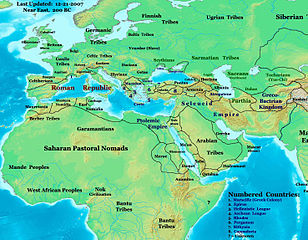
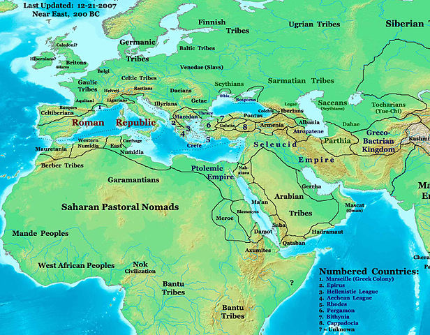
English: This image is a zoomed-in version of Eastern Hemisphere in 200 BC.
Author: Thomas A. Lessman. Source URL: http://www.ThomasLessman.com/History/images/East-Hem_200bc.jpg. Image was created by me (Thomas Lessman) based on map of Eastern Hemisphere in 200 BC. Image is free for public and/or educational use. I would appreciate a mention if this image is used elsewhere. If anyone is interested in helping further this work, please contact Thomas Lessman at talessman@yis.us. Other Historical Maps by Thomas Lessman100 BC. 5.[3]. 6.[4]. 7.[5]. 8.[6]. 9.[7]. 10.[8]. 11.[9]. 12.[10]. 13.[11]. 14.[12]. 15.[13]. 16.[14]. 17.[15]. 18.[16]. 19.[17]. 20.[18]. 21.[19]. 22.[20]. 23.[21]. |
| Boarne | Transferred from en.wikipedia by SreeBot |
| Auteur | Talessman at en.wikipedia |
| Oare ferzjes |
 |
Lisinsje
Talessman at en.wikipedia, the copyright holder of this work, hereby publishes it under the following licenses:
This file is licensed under the Creative Commons Attribution 3.0 Unported license.
Nammefermelding: Talessman at en.wikipedia
- Fiel jo frij:
- te dielen – it wurk te kopiearjen, fersprieden en út te stjoeren
- te fermingen – it wurk oan te passen
- Under de neikommende betingsten:
- Nammefermelding – You must give appropriate credit, provide a link to the license, and indicate if changes were made. You may do so in any reasonable manner, but not in any way that suggests the licensor endorses you or your use.

|
Der wurdt tastimming jûn ta kopiearjen, fersprieden en/of wizigjen fan dit dokumint ûnder de betinksten fan de GNU-lisinsje foar iepen dokumintaasje, ferzje 1.2, as eltse lettere ferzje útjûn troch de Free Software Foundation; sûnder Ynfariante Seksjes, sûnder Omkaftteksten foar de Foarkante en sûnder Omkaftteksten foar de Efterkante. In kopy fan de lisinsje is opnaam yn de seksje "Text of the GNU Free Documentation License". |
You may select the license of your choice.
Original upload log
The original description page was here. All following user names refer to en.wikipedia.
Upload date | User | Bytes | Dimensions | Comment
- 2008-01-22 17:20 (UTC) | Talessman | 524492 (bytes) | 1474×1148 | Added more info for Europe and Africa, added numbered legend, etc.
- 2007-10-26 20:11 (UTC) | Talessman | 315509 (bytes) | 1246×811 | Author: Thomas A. Lessman. Source URL: http://www.ThomasLessman.com/History/images/East-Hem_200bc.jpg. Image was created by me (Thomas Lessman) based on map of Eastern Hemisphere in 200BC. Image is free for public and/or educational use. I would appreciat
Triemskiednis
Klik op in datum/tiid om it bestân te besjen sa't it op dat stuit wie.
| Datum/Tiid | Miniatuer | ôfmjittings | Meidogger | Opmerking | |
|---|---|---|---|---|---|
| lêste | 12 sep 2011, 12.50 | | 1.474 × 1.148 (512 KB) | SreeBot | (Original text) : Added more info for Europe and Africa, added numbered legend, etc. |
Bestânsgebrûk
De neikommende side brûkt dit bestân:
Globaal bestânsgebrûk
De neikommende oare wiki's brûke dit bestân:
- Gebrûk op ar.wikipedia.org
- Gebrûk op arz.wikipedia.org
- Gebrûk op ca.wikipedia.org
- Gebrûk op el.wikipedia.org
- Gebrûk op en.wikipedia.org
- Gebrûk op et.wikipedia.org
- Gebrûk op hu.wikipedia.org
- Gebrûk op it.wikipedia.org
- Gebrûk op ms.wikipedia.org
- Gebrûk op ro.wikipedia.org
- Gebrûk op ru.wikipedia.org
- Gebrûk op sl.wikipedia.org
- Gebrûk op tr.wikipedia.org
- Gebrûk op uk.wikipedia.org
- Gebrûk op vi.wikipedia.org