
Ofbyld:Mecklenburg-Vorpommern location map G.svg

Size of this PNG preview of this SVG file: 800 × 549 piksels. Oare resolúsjes: 320 × 220 piksels | 640 × 439 piksels | 1.024 × 703 piksels | 1.280 × 879 piksels | 2.560 × 1.757 piksels | 1.129 × 775 piksels.
Oarspronklik bestân (SVG-bestân, nominaal 1.129 × 775 pixels, bestânsgrutte: 485 KB)
| Beskriuwing |
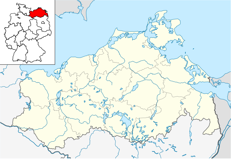
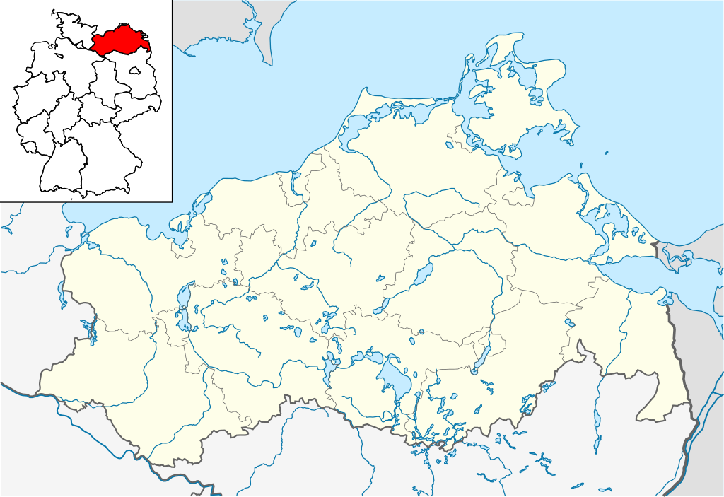
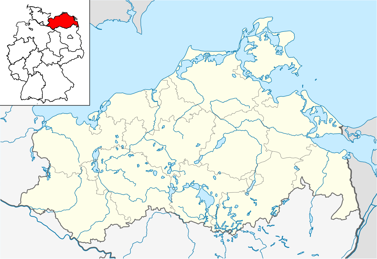
Quadratische Plattkarte, N-S-Streckung 160 %. Geographische Begrenzung der Karte:
English: Location map of Mecklenburg-Vorpommern, showing position of Mecklenburg-Vorpommern within Germany
Equirectangular projection, N/S stretching 160 %. Geographic limits of the map:
|
| Datum | |
| Boarne | own work, based on File:Mecklenburg-Vorpommern location map.svg |
| Auteur | Hanhil based on work by NordNordWest |
Lisinsje
I, the copyright holder of this work, hereby publish it under the following licenses:

|
Der wurdt tastimming jûn ta kopiearjen, fersprieden en/of wizigjen fan dit dokumint ûnder de betinksten fan de GNU-lisinsje foar iepen dokumintaasje, ferzje 1.2, as eltse lettere ferzje útjûn troch de Free Software Foundation; sûnder Ynfariante Seksjes, sûnder Omkaftteksten foar de Foarkante en sûnder Omkaftteksten foar de Efterkante. In kopy fan de lisinsje is opnaam yn de seksje "Text of the GNU Free Documentation License". |
This file is licensed under the Creative Commons Attribution-Share Alike 3.0 Unported license.
- Fiel jo frij:
- te dielen – it wurk te kopiearjen, fersprieden en út te stjoeren
- te fermingen – it wurk oan te passen
- Under de neikommende betingsten:
- Nammefermelding – You must give appropriate credit, provide a link to the license, and indicate if changes were made. You may do so in any reasonable manner, but not in any way that suggests the licensor endorses you or your use.
- Lyk diele – If you remix, transform, or build upon the material, you must distribute your contributions under the same or compatible license as the original.
You may select the license of your choice.
Triemskiednis
Klik op in datum/tiid om it bestân te besjen sa't it op dat stuit wie.
| Datum/Tiid | Miniatuer | ôfmjittings | Meidogger | Opmerking | |
|---|---|---|---|---|---|
| lêste | 31 mai 2009, 00.42 | | 1.129 × 775 (485 KB) | Michiel1972 | frame |
| 22 mai 2009, 10.48 |  | 1.129 × 775 (481 KB) | Hanhil | {{Information |Description= {{de|Positionskarte von Mecklenburg-Vorpommern, einschl. der Lage innerhalb Deutschlands}} Quadratische Plattkarte, N-S-Streckung 160 %. Geographische Begrenzung der Karte: * N |
Bestânsgebrûk
De neikommende 10 siden brûke dit bestân:
Globaal bestânsgebrûk
De neikommende oare wiki's brûke dit bestân:
- Gebrûk op de.wikivoyage.org
- Gebrûk op fa.wikipedia.org
- Gebrûk op ka.wikipedia.org
- Gebrûk op ko.wikipedia.org
- Gebrûk op nl.wikipedia.org
- Wismar
- Anklam
- Schwerin
- Rostock (stad)
- Bad Doberan (stad)
- Kröpelin
- Kühlungsborn
- Sanitz
- Satow
- Demmin (stad)
- Teterow
- Boizenburg/Elbe
- Hagenow
- Ludwigslust (stad)
- Lübtheen
- Waren (Müritz)
- Neubrandenburg
- Grimmen
- Parchim (stad)
- Stralsund
- Pasewalk
- Strasburg (Uckermark)
- Ueckermünde
- Greifswald
- Warnemünde
- Peenemünde
- Prora
- Vitt
- Zingst
- Friedland (Mecklenburg)
- Neustrelitz
- Admannshagen-Bargeshagen
- Ahrenshagen-Daskow
- Ahrenshoop
- Alt Bukow
- Altefähr
- Altenpleen
- Altentreptow
- Altkalen
- Alt Krenzlin
- Alt Meteln
- Alt Rehse
Mear globaal gebrûk fan dit bestân besjen.