
Ofbyld:Maricopa County Incorporated and Planning areas Scottsdale highlighted.svg

Size of this PNG preview of this SVG file: 694 × 599 piksels. Oare resolúsjes: 278 × 240 piksels | 556 × 480 piksels | 889 × 768 piksels | 1.185 × 1.024 piksels | 2.371 × 2.048 piksels | 940 × 812 piksels.
Oarspronklik bestân (SVG-bestân, nominaal 940 × 812 pixels, bestânsgrutte: 1,05 MB)
Gearfetting
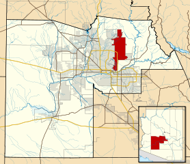
| Beskriuwing | This map shows the incorporated areas and Indian reservation boundaries in Maricopa County, Arizona, along with water bodies and major highways and roads. Scottsdale is highlighted in red. Other incorporated cities are shown in gray, planning area borders for these cities and Indian reservation borders are shown as solid black lines. Changes from Previous Version: Updated the maps to include water bodies and to make "less boring" than the plain black/white/gray maps. Format was updated to match standards laid out by WikiProject Maps/Conventions. Map data is based on data from the following Webpage: Maricopa County Interactive GIS Map. I created this map in Inkscape. |
| Datum | |
| Boarne | My own work, based on government information |
| Auteur | Ixnayonthetimmay |
| Tastimming (Reusing this file) |
Public Domain |
| Oare ferzjes | See Category:Maps of Maricopa County for other versions of this image. |
Lisinsje
| I, the copyright holder of this work, release this work into the public domain. This applies worldwide. In some countries this may not be legally possible; if so: I grant anyone the right to use this work for any purpose, without any conditions, unless such conditions are required by law. |
Triemskiednis
Klik op in datum/tiid om it bestân te besjen sa't it op dat stuit wie.
| Datum/Tiid | Miniatuer | ôfmjittings | Meidogger | Opmerking | |
|---|---|---|---|---|---|
| lêste | 20 mai 2011, 08.41 | | 940 × 812 (1,05 MB) | Ixnayonthetimmay | Uploading new version |
| 30 aug 2008, 06.39 |  | 900 × 800 (413 KB) | Ixnayonthetimmay | == Summary == {{Information |Description=This map shows the incorporated areas and unincorporated areas in Maricopa County, Arizona. [[:en:Paloma, Arizona|Pa | |
| 16 sep 2007, 02.05 |  | 900 × 800 (384 KB) | Ixnayonthetimmay | {{Information |Description= |Source= |Date= |Author= |Permission= |other_versions= }} | |
| 28 mai 2007, 12.13 |  | 900 × 780 (329 KB) | Ixnayonthetimmay | ||
| 22 mai 2007, 03.15 |  | 900 × 780 (318 KB) | Ixnayonthetimmay | ||
| 30 jan 2007, 07.24 |  | 904 × 758 (177 KB) | Ixnayonthetimmay | {{Information |Description=This map shows the incorporated areas in Maricopa County, Arizona, highlighting Scottsdale in red. It also shows the boundaries for |
Bestânsgebrûk
Der binne gjin siden dy't dit bestân brûke.
Globaal bestânsgebrûk
De neikommende oare wiki's brûke dit bestân:
- Gebrûk op ar.wikipedia.org
- Gebrûk op arz.wikipedia.org
- Gebrûk op br.wikipedia.org
- Gebrûk op ca.wikipedia.org
- Gebrûk op ceb.wikipedia.org
- Gebrûk op de.wikipedia.org
- Gebrûk op el.wikipedia.org
- Gebrûk op eo.wikipedia.org
- Gebrûk op eu.wikipedia.org
- Gebrûk op fa.wikipedia.org
- Gebrûk op fr.wikipedia.org
- Gebrûk op ga.wikipedia.org
- Gebrûk op gl.wikipedia.org
- Gebrûk op ht.wikipedia.org
- Gebrûk op hu.wikipedia.org
- Gebrûk op id.wikipedia.org
- Gebrûk op it.wikipedia.org
- Gebrûk op ja.wikipedia.org
- Gebrûk op kw.wikipedia.org
- Gebrûk op mg.wikipedia.org
- Gebrûk op ms.wikipedia.org
- Gebrûk op pms.wikipedia.org
- Gebrûk op ro.wikipedia.org
- Gebrûk op sr.wikipedia.org
- Gebrûk op sv.wikipedia.org
- Gebrûk op sw.wikipedia.org
- Gebrûk op tr.wikipedia.org
- Gebrûk op tt.wikipedia.org
- Gebrûk op ur.wikipedia.org
- Gebrûk op vi.wikipedia.org
- Gebrûk op vo.wikipedia.org
- Gebrûk op www.wikidata.org
- Gebrûk op zh.wikipedia.org