
Ofbyld:Map of the Imperial Circles (1512)-de.png

Grutte fan dit proefbyld: 610 × 599 piksels. Oare resolúsjes: 244 × 240 piksels | 489 × 480 piksels | 727 × 714 piksels.
Oarspronklik bestân (727 × 714 pixels, bestânsgrutte: 67 KB, MIME-type: image/png)
| Beskriuwing |
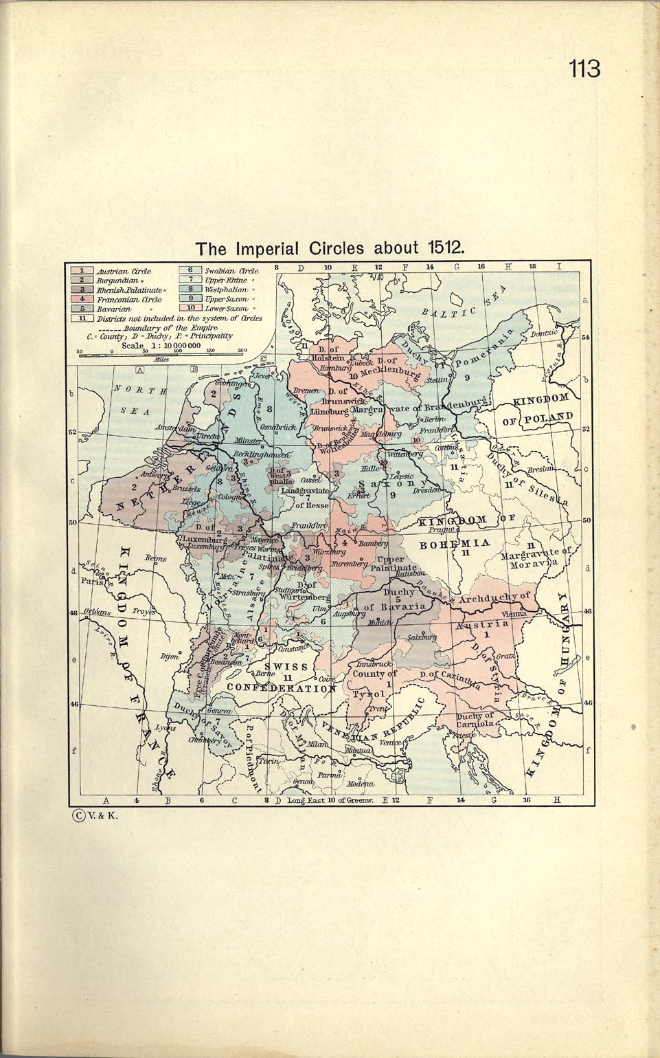
English: Map of the Imperial Circles (1512)-de. |
| Boarne |
|
| Auteur | I am the author of this image file. |
| Oare ferzjes |
[] 1512
1560
|
-bg.png)
-de.png)
-en.png)
-fr.svg)
.png)
-de.svg)
-en.svg)
-es.svg)
-la.svg)
-nl.svg)
-de.png)
![[1]](https://maps.lib.utexas.edu/maps/historical/shepherd/imperial_circles_1512.jpg)
This file is licensed under the Creative Commons Attribution-Share Alike 2.0 Germany license.
- Fiel jo frij:
- te dielen – it wurk te kopiearjen, fersprieden en út te stjoeren
- te fermingen – it wurk oan te passen
- Under de neikommende betingsten:
- Nammefermelding – You must give appropriate credit, provide a link to the license, and indicate if changes were made. You may do so in any reasonable manner, but not in any way that suggests the licensor endorses you or your use.
- Lyk diele – If you remix, transform, or build upon the material, you must distribute your contributions under the same or compatible license as the original.

Triemskiednis
Klik op in datum/tiid om it bestân te besjen sa't it op dat stuit wie.
| Datum/Tiid | Miniatuer | ôfmjittings | Meidogger | Opmerking | |
|---|---|---|---|---|---|
| lêste | 30 okt 2005, 18.31 | | 727 × 714 (67 KB) | Finanzer | *I am the author of this image file. *Its contents are based in part on a map published in the "Historical Atlas" by Prof. William R Shepherd, pub. Henry Holt & Co. (New York, 1911). *first uploaded to de-WP: 14:50, 15. Okt 200 |
Bestânsgebrûk
De neikommende 5 siden brûke dit bestân:
Globaal bestânsgebrûk
De neikommende oare wiki's brûke dit bestân:
- Gebrûk op af.wikipedia.org
- Gebrûk op azb.wikipedia.org
- Gebrûk op da.wikipedia.org
- Gebrûk op de.wikipedia.org
- Heiliges Römisches Reich
- Niedersachsen
- 1512
- Geschichte Kärntens
- Reichstage zu Augsburg
- Geschichte Luxemburgs
- Krain
- Vorderösterreich
- Erste Wiener Türkenbelagerung
- Tarasp
- Geschichte der Steiermark
- Grafschaft Schaunberg
- Bistum Chur
- Deutschordensballei An der Etsch und im Gebirge
- Görz und Gradisca
- Diözese Bozen-Brixen
- Reichsreform (Heiliges Römisches Reich)
- Österreichischer Reichskreis
- Diskussion:Balkanhalbinsel/Archiv
- Geschichte Niederösterreichs
- Diskussion:Schwäbischer Reichskreis
- Erzbistum Trient
- Herzogtum Salzburg
- Gefürstete Grafschaft Tirol
- Markgrafschaft Istrien
- Geschichte Oberösterreichs
- Luxemburg
- Burgundischer Vertrag
- Guestphalia
- Erzherzogtum Österreich
- Nicht eingekreiste zum Heiligen Römischen Reich zugehörige Territorien und Stände
- Vorlage:Navigationsleiste Österreichischer Reichskreis
- Ballei Österreich des Deutschen Ordens
- Reichsunmittelbare Stadt Triest und ihr Gebiet
- Benutzer:Daniel L.F./Vertonung/Heiliges Römisches Reich
- Musikjahr 1580
- Musikjahr 1587
- Herrschaft Tarasp
- Wikipedia:WikiProjekt Österreich/checks/Navis/Österreich
- Gebrûk op eo.wikipedia.org
- Gebrûk op gv.wikipedia.org
- Gebrûk op hu.wikipedia.org
- Gebrûk op it.wikipedia.org
- Gebrûk op ja.wikipedia.org
- Gebrûk op nl.wikipedia.org
Mear globaal gebrûk fan dit bestân besjen.
-de.png)
-de.png)