
Ofbyld:Map of American Samoa admin.png

Grutte fan dit proefbyld: 776 × 600 piksels. Oare resolúsjes: 311 × 240 piksels | 621 × 480 piksels | 994 × 768 piksels | 1.280 × 989 piksels | 2.112 × 1.632 piksels.
Oarspronklik bestân (2.112 × 1.632 pixels, bestânsgrutte: 44 KB, MIME-type: image/png)

|
This map image could be re-created using vector graphics as an SVG file. This has several advantages; see Commons:Media for cleanup for more information. If an SVG form of this image is available, please upload it and afterwards replace this template with
{{vector version available|new image name}}.
It is recommended to name the SVG file “Map of American Samoa admin.svg”—then the template Vector version available (or Vva) does not need the new image name parameter. |
Gearfetting
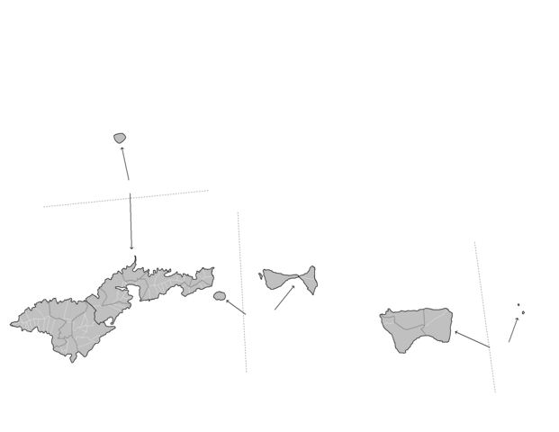
| Beskriuwing | Map of the administrative divisions of American Samoa. Map is to scale, with distances between the various islands displayed. Created by Rarelibra 17:29, 11 January 2008 (UTC) for public domain use, using MapInfo Professional v8.5 and various mapping resources. |
| Datum | 11 jannewaris 2008 (original upload date) |
| Boarne | Geen machineleesbare bron opgegeven. Eigen werk aangenomen (gebaseerd op auteursrechtclaims). |
| Auteur | Geen machineleesbare auteur aanwezig. Op basis van auteursrechtclaims wordt auteur Rarelibra aangenomen. |
Lisinsje
| I, the copyright holder of this work, release this work into the public domain. This applies worldwide. In some countries this may not be legally possible; if so: I grant anyone the right to use this work for any purpose, without any conditions, unless such conditions are required by law. |
Triemskiednis
Klik op in datum/tiid om it bestân te besjen sa't it op dat stuit wie.
| Datum/Tiid | Miniatuer | ôfmjittings | Meidogger | Opmerking | |
|---|---|---|---|---|---|
| lêste | 4 des 2010, 17.51 | | 2.112 × 1.632 (44 KB) | Beao | Transparent. |
| 11 jan 2008, 19.29 |  | 2.112 × 1.632 (37 KB) | Rarelibra | Map of the administrative divisions of American Samoa. Map is to scale, with distances between the various islands displayed. Created by ~~~~ for public domain use, using MapInfo Professional v8.5 and various mapping resources. |
Bestânsgebrûk
De neikommende side brûkt dit bestân:
Globaal bestânsgebrûk
De neikommende oare wiki's brûke dit bestân:
- Gebrûk op ja.wikipedia.org
- Gebrûk op mt.wikipedia.org
- Gebrûk op nl.wikipedia.org