
Ofbyld:Map indicating Amundsen Gulf, Northwest Territories, Canada.png
Gjin hegere resolúsje beskikber.
Map_indicating_Amundsen_Gulf,_Northwest_Territories,_Canada.png (395 × 370 pixels, bestânsgrutte: 60 KB, MIME-type: image/png)
Gearfetting
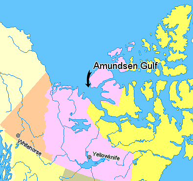
Map indicating Amundsen Gulf, Northwest Territories, Canada.
Nunavut
Northwest Territories
Yukon Territory
British Columbia
Alaska
© Her Majesty the Queen in Right of Canada, Department of Natural Resources. All rights reserved.
Licence Agreement
Lisinsje

|
The copyright holder of this work allows anyone to use it for any purpose including unrestricted redistribution, commercial use, and modification.
Usage notes:
|
Triemskiednis
Klik op in datum/tiid om it bestân te besjen sa't it op dat stuit wie.
| Datum/Tiid | Miniatuer | ôfmjittings | Meidogger | Opmerking | |
|---|---|---|---|---|---|
| lêste | 21 mrt 2006, 03.42 | | 395 × 370 (60 KB) | David Kernow~commonswiki | Map indicating Amundsen Gulf, Northwest Territories, Canada. {{legend|#ffff66|Nunavut}} {{legend|#ffccff|Northwest Territories}} {{legend|#ffcc99|Yukon Territory}} {{legend|#ffff99|British Columbia}} {{legend|#ffffcc|Alaska}} <br> © |
Bestânsgebrûk
De neikommende side brûkt dit bestân:
Globaal bestânsgebrûk
De neikommende oare wiki's brûke dit bestân:
- Gebrûk op af.wikipedia.org
- Gebrûk op az.wikipedia.org
- Gebrûk op bg.wikipedia.org
- Gebrûk op bn.wikipedia.org
- Gebrûk op bs.wikipedia.org
- Gebrûk op cs.wikipedia.org
- Gebrûk op de.wikipedia.org
- Gebrûk op en.wikipedia.org
- Gebrûk op eo.wikipedia.org
- Gebrûk op es.wikipedia.org
- Gebrûk op et.wikipedia.org
- Gebrûk op eu.wikipedia.org
- Gebrûk op fa.wikipedia.org
- Gebrûk op fr.wikipedia.org
- Gebrûk op hi.wikipedia.org
- Gebrûk op ilo.wikipedia.org
- Gebrûk op it.wikipedia.org
- Gebrûk op ja.wikipedia.org
- Gebrûk op ka.wikipedia.org
- Gebrûk op ko.wikipedia.org
- Gebrûk op ku.wikipedia.org
- Gebrûk op la.wikipedia.org
- Gebrûk op lt.wikipedia.org
- Gebrûk op mk.wikipedia.org
- Gebrûk op nl.wikipedia.org
- Gebrûk op nn.wikipedia.org
- Gebrûk op pa.wikipedia.org
- Gebrûk op pl.wikipedia.org
- Gebrûk op pl.wiktionary.org
- Gebrûk op pnb.wikipedia.org
- Gebrûk op sh.wikipedia.org
- Gebrûk op sl.wikipedia.org
- Gebrûk op sr.wikipedia.org
- Gebrûk op tr.wikipedia.org
- Gebrûk op uk.wikipedia.org
- Gebrûk op ur.wikipedia.org
- Gebrûk op vi.wikipedia.org
- Gebrûk op war.wikipedia.org
- Gebrûk op xmf.wikipedia.org
- Gebrûk op zh-min-nan.wikipedia.org
- Gebrûk op zh.wikipedia.org