Ofbyld:Malaysia Airlines Flight 17 crash site.png

Page contents not supported in other languages.
Ut Wikipedy

Malaysia_Airlines_Flight_17_crash_site.png(451 × 456 pixels, bestânsgrutte: 62 KB, MIME-type: image/png)

Dit bestân komt fan Wikimedia Commons, en kin ek troch oare projekten brûkt wurde. De beskriuwing op syn bestânsside dêre wurdt hjirûnder werjûn.

Gearfetting

Beskriuwing
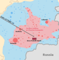
English: Map of the crash of Malaysia Airlines Flight 17.

Black line - the route of Malaysia Airlines Flight 17

 
Extent of territory held by pro-Russian insurgents (at the moment of the crash)
 
Territory previously held by the insurgents, but since retaken by the Ukrainian government
 
Russian territory
 
Approximate area of missile launch according to allegations of the Ukrainian Council of National Security and Defense (see the source for details) Circles are population centres - the larger the circle the larger the population.
This incident map image could be re-created using vector graphics as an SVG file. This has several advantages; see Commons:Media for cleanup for more information. If an SVG form of this image is available, please upload it and afterwards replace this template with {{vector version available|new image name}}.


It is recommended to name the SVG file “Malaysia Airlines Flight 17 crash site.svg”—then the template Vector version available (or Vva) does not need the new image name parameter.
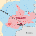
Русский: Место падения Boeing 777 в катастрофе от 17 июля. Источник данных (The New York Times)

Черная линия - маршрут Boeing 777

 
Территория, контролируемая пророссийскими повстанцами (на момент катастрофы)
 
Территория, которую вернули под свой контроль украинские власти
 
Территория России
 
Ориентировочное место запуска ракеты в соответствии с утверждениями правительства Украины (см. указанный источник данных) Круги это населенные пункты, чем больше круг - тем больше население.
Datum
Boarne

(21 July 2014). "Maps of the Crash of Malaysia Airlines Flight 17". New York Times. Retrieved on 8 June 2015. Map labeled "Crash Site and Missile Launch Within Area of Rebel Activity" (17 July 2014) Source data: Ukrainian Council of National Security and Defense

This file was derived from: East Ukraine conflict.png
Auteur Alex1961
Oare ferzjes

[bewurkje]

English: Base maps
English: Other maps

Lisinsje

I, the copyright holder of this work, hereby publish it under the following licenses:
GNU head Der wurdt tastimming jûn ta kopiearjen, fersprieden en/of wizigjen fan dit dokumint ûnder de betinksten fan de GNU-lisinsje foar iepen dokumintaasje, ferzje 1.2, as eltse lettere ferzje útjûn troch de Free Software Foundation; sûnder Ynfariante Seksjes, sûnder Omkaftteksten foar de Foarkante en sûnder Omkaftteksten foar de Efterkante. In kopy fan de lisinsje is opnaam yn de seksje "Text of the GNU Free Documentation License".
w:fy:Creative Commons
Nammefermelding Lyk diele
This file is licensed under the Creative Commons Attribution-Share Alike 3.0 Unported license.
Fiel jo frij:
  • te dielen – it wurk te kopiearjen, fersprieden en út te stjoeren
  • te fermingen – it wurk oan te passen
Under de neikommende betingsten:
  • Nammefermelding – You must give appropriate credit, provide a link to the license, and indicate if changes were made. You may do so in any reasonable manner, but not in any way that suggests the licensor endorses you or your use.
  • Lyk diele – If you remix, transform, or build upon the material, you must distribute your contributions under the same or compatible license as the original.
You may select the license of your choice.

Captions

Add a one-line explanation of what this file represents

Items portrayed in this file

depicts Ingelsk

copyrighted Ingelsk

inception Ingelsk

19 jul 2014

Triemskiednis

Klik op in datum/tiid om it bestân te besjen sa't it op dat stuit wie.

Datum/TiidMiniatuerôfmjittingsMeidoggerOpmerking
lêste23 jul 2014, 14.43Miniatuer foar de ferzje fan 23 jul 2014 om 14.43451 × 456 (62 KB)CmgleeMake colour of rest of Ukraine more different from that of Russia.
23 jul 2014, 14.16Miniatuer foar de ferzje fan 23 jul 2014 om 14.16451 × 456 (63 KB)Alex1961labels
19 jul 2014, 13.11Miniatuer foar de ferzje fan 19 jul 2014 om 13.11451 × 456 (54 KB)Alex1961оформление
19 jul 2014, 12.52Miniatuer foar de ferzje fan 19 jul 2014 om 12.52451 × 456 (54 KB)Alex1961оформление
19 jul 2014, 12.46Miniatuer foar de ferzje fan 19 jul 2014 om 12.46451 × 456 (62 KB)Alex1961User created page with UploadWizard

De neikommende side brûkt dit bestân:

Globaal bestânsgebrûk

De neikommende oare wiki's brûke dit bestân: