
Ofbyld:Littlemissouririvermap.png

Grutte fan dit proefbyld: 571 × 600 piksels. Oare resolúsjes: 228 × 240 piksels | 457 × 480 piksels | 836 × 878 piksels.
Oarspronklik bestân (836 × 878 pixels, bestânsgrutte: 1.019 KB, MIME-type: image/png)
Gearfetting
| Beskriuwing |
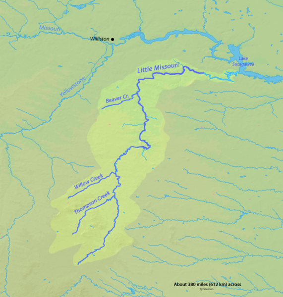
English: Map of the Little Missouri River watershed in Wyoming, Montana and North Dakota in the north-central USA, that drains to the Missouri River |
| Datum | |
| Boarne | Background and river course data from http://www2.demis.nl/mapserver/mapper.asp |
| Auteur | Shannon |
| Tastimming (Reusing this file) |
Map created from DEMIS Mapserver, which are public domain. |
Lisinsje
I, the copyright holder of this work, hereby publish it under the following licenses:

|
Der wurdt tastimming jûn ta kopiearjen, fersprieden en/of wizigjen fan dit dokumint ûnder de betinksten fan de GNU-lisinsje foar iepen dokumintaasje, ferzje 1.2, as eltse lettere ferzje útjûn troch de Free Software Foundation; sûnder Ynfariante Seksjes, sûnder Omkaftteksten foar de Foarkante en sûnder Omkaftteksten foar de Efterkante. In kopy fan de lisinsje is opnaam yn de seksje "Text of the GNU Free Documentation License". |
This file is licensed under the Creative Commons Attribution-Share Alike 4.0 International, 3.0 Unported, 2.5 Generic, 2.0 Generic and 1.0 Generic license.
- Fiel jo frij:
- te dielen – it wurk te kopiearjen, fersprieden en út te stjoeren
- te fermingen – it wurk oan te passen
- Under de neikommende betingsten:
- Nammefermelding – You must give appropriate credit, provide a link to the license, and indicate if changes were made. You may do so in any reasonable manner, but not in any way that suggests the licensor endorses you or your use.
- Lyk diele – If you remix, transform, or build upon the material, you must distribute your contributions under the same or compatible license as the original.
You may select the license of your choice.
Triemskiednis
Klik op in datum/tiid om it bestân te besjen sa't it op dat stuit wie.
| Datum/Tiid | Miniatuer | ôfmjittings | Meidogger | Opmerking | |
|---|---|---|---|---|---|
| lêste | 16 feb 2010, 04.29 | | 836 × 878 (1.019 KB) | Shannon1 | {{Information |Description={{en|1=Map of the Little Missouri River watershed in Wyoming, Montana and North Dakota in the north-central USA, that drains to the Missouri River}} |Source=Background and river course data from http://www2.demis.nl/mapserver/ma |
Bestânsgebrûk
De neikommende side brûkt dit bestân:
Globaal bestânsgebrûk
De neikommende oare wiki's brûke dit bestân:
- Gebrûk op bg.wikipedia.org
- Gebrûk op da.wikipedia.org
- Gebrûk op de.wikipedia.org
- Gebrûk op en.wikipedia.org
- Gebrûk op es.wikipedia.org
- Gebrûk op ja.wikipedia.org
- Gebrûk op lt.wikipedia.org
- Gebrûk op pl.wikipedia.org
- Gebrûk op ru.wikipedia.org
- Gebrûk op xmf.wikipedia.org
- Gebrûk op zh.wikipedia.org