
Ofbyld:IBCAO betamap.jpg
Grutte fan dit proefbyld: 526 × 599 piksels. Oare resolúsjes: 211 × 240 piksels | 421 × 480 piksels | 762 × 868 piksels.
Oarspronklik bestân (762 × 868 pixels, bestânsgrutte: 710 KB, MIME-type: image/jpeg)
| Description |
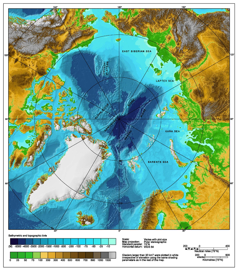
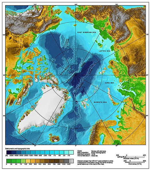
Bathymetric map of the Arctic Ocean |
|||||||||
| Boarne | http://www.ngdc.noaa.gov/mgg/image/IBCAO_betamap.jpg | |||||||||
| Tastimming (Reusing this file) |
|
|||||||||
| Geotemporal data | ||||||||||
| Bounding box |
|
|||||||||
| Georeferencing | ||||||||||
| Oare ferzjes |
Derivative works of this file: |
|||||||||
Triemskiednis
Klik op in datum/tiid om it bestân te besjen sa't it op dat stuit wie.
| Datum/Tiid | Miniatuer | ôfmjittings | Meidogger | Opmerking | |
|---|---|---|---|---|---|
| lêste | 2 aug 2007, 02.29 | | 762 × 868 (710 KB) | Mikkalai | Source: http://www.ngdc.noaa.gov/mgg/image/IBCAO_betamap.jpg Bathymetric map of the w:Arctic Ocean |
Bestânsgebrûk
De neikommende side brûkt dit bestân:
Globaal bestânsgebrûk
De neikommende oare wiki's brûke dit bestân:
- Gebrûk op af.wikipedia.org
- Gebrûk op ar.wikipedia.org
- Gebrûk op ary.wikipedia.org
- Gebrûk op ast.wikipedia.org
- Gebrûk op avk.wikipedia.org
- Gebrûk op azb.wikipedia.org
- Gebrûk op bcl.wikipedia.org
- Gebrûk op be.wikipedia.org
- Gebrûk op bg.wikipedia.org
- Gebrûk op bh.wikipedia.org
- Gebrûk op bn.wikipedia.org
- Gebrûk op bxr.wikipedia.org
- Gebrûk op ca.wikipedia.org
- Gebrûk op ceb.wikipedia.org
- Gebrûk op chr.wikipedia.org
- Gebrûk op co.wikipedia.org
- Gebrûk op crh.wikipedia.org
- Gebrûk op cs.wikipedia.org
- Gebrûk op da.wikipedia.org
- Gebrûk op de.wikipedia.org
- Gebrûk op dty.wikipedia.org
- Gebrûk op en.wikipedia.org
- Talk:Lomonosov Ridge
- Territorial claims in the Arctic
- Arktika 2007
- Portal:Maps/Maps/Geographic
- Portal:Maps/Maps/Geographic/2
- Arctic Ocean
- User:Wiki User 68/My Portal
- User:Wiki User 68/My Portal/Selected geography/1
- List of Russian explorers
- Wikipedia:Reference desk/Archives/Science/2015 May 29
- User:Joelton Ivson/Gather lists/24441 – Conflitos internacionais
- Portal:Maps
- Gebrûk op en.wikinews.org
- Gebrûk op en.wikiversity.org
- Gebrûk op eo.wikipedia.org
- Gebrûk op es.wikipedia.org
Mear globaal gebrûk fan dit bestân besjen.