
Ofbyld:Empire akkad.svg

Oarspronklik bestân (SVG-bestân, nominaal 1.475 × 1.149 pixels, bestânsgrutte: 2,34 MB)
Gearfetting

|
This SVG file contains embedded text that can be translated into your language, using any capable SVG editor, text editor or the SVG Translate tool. For more information see: About translating SVG files. |
| Beskriuwing |
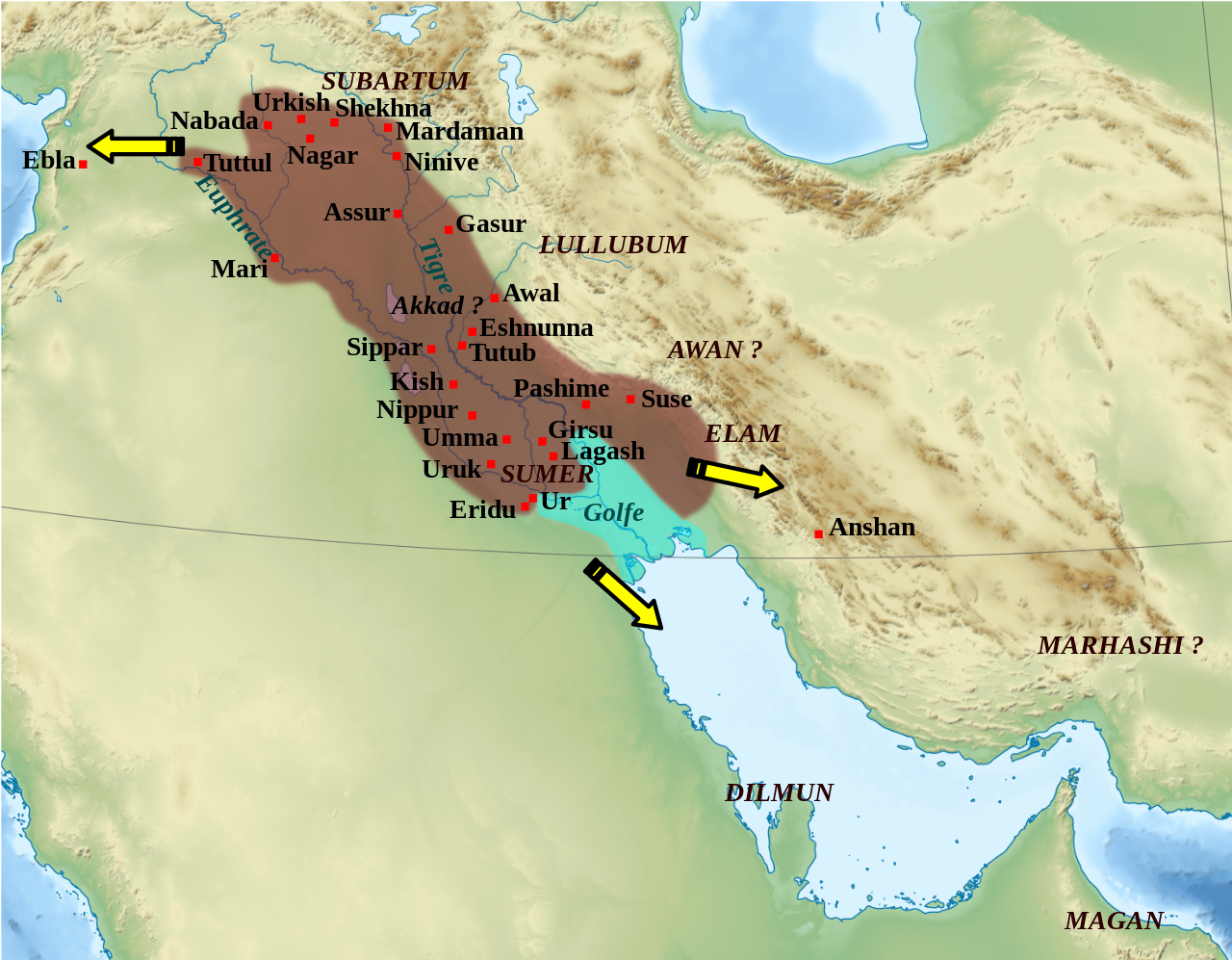
English: Mapa que mostra l'extensió aproximada de l'imperi Accadi durant el regnat de Narâm-Sîn (2254-2218 a.C. en la cronologia breu). Français : Carte de l'extension approximative de l'empire d'Akkad sous le règne de Narâm-Sîn (2254-2218 av. J.-C. selon la chronologie moyenne), et des directions des campagnes militaires extérieures. Sources : B. Lafont et M. Sauvage dans M. Sauvage (dir.), Atlas historique du Proche-Orient ancien, Paris, Les Belles Lettres, 2020, p. 70 ; P. Michalowski, « The Kingdom of Akkad in Contact with the World », dans The Oxford History of the Ancient Near East, Volume 1: From the Beginnings to Old Kingdom Egypt and the Dynasty of Akkad, New York, Oxford University Press, 2020, p. 688 fig. 10.1. |
| Datum | (UTC) |
| Boarne | |
| Auteur |
|
| Oare ferzjes |
File:Empire akkad.svg has 2 translations.
Other related versions: []
|


| Camera location | | View this and other nearby images on: OpenStreetMap |
|---|
|
|
This SVG file contains embedded text that can be translated into your language, using any capable SVG editor, text editor or the SVG Translate tool. For more information see: About translating SVG files. |
This file is translated using SVG <switch> elements. All translations are stored in the same file! Learn more.
For most Wikipedia projects, you can embed the file normally (without a To translate the text into your language, you can use the SVG Translate tool. Alternatively, you can download the file to your computer, add your translations using whatever software you're familiar with, and re-upload it with the same name. You will find help in Graphics Lab if you're not sure how to do this. |
| This is a retouched picture, which means that it has been digitally altered from its original version. Modifications: Ajout des villes, du contour approximatif de l'empire.. The original can be viewed here: Middle East topographic map-blank.svg:
|
Lisinsje
- Fiel jo frij:
- te dielen – it wurk te kopiearjen, fersprieden en út te stjoeren
- te fermingen – it wurk oan te passen
- Under de neikommende betingsten:
- Nammefermelding – You must give appropriate credit, provide a link to the license, and indicate if changes were made. You may do so in any reasonable manner, but not in any way that suggests the licensor endorses you or your use.
- Lyk diele – If you remix, transform, or build upon the material, you must distribute your contributions under the same or compatible license as the original.

|
Der wurdt tastimming jûn ta kopiearjen, fersprieden en/of wizigjen fan dit dokumint ûnder de betinksten fan de GNU-lisinsje foar iepen dokumintaasje, ferzje 1.2, as eltse lettere ferzje útjûn troch de Free Software Foundation; sûnder Ynfariante Seksjes, sûnder Omkaftteksten foar de Foarkante en sûnder Omkaftteksten foar de Efterkante. In kopy fan de lisinsje is opnaam yn de seksje "Text of the GNU Free Documentation License". |
Original upload log
This image is a derivative work of the following images:
- File:Middle_East_topographic_map-blank.svg licensed with Cc-by-sa-3.0,2.5,2.0,1.0, GFDL
- 2010-11-03T17:52:56Z Sémhur 3097x1938 (10510751 Bytes) == {{int:filedesc}} == {{Information |Description={{Multilingual description |en= Blank physical map of the [[:en:Middle East|Middle East]] |fr= Carte physique vierge du [[:fr:Moyen-Orient|Moyen-Orient]]. }} |Source={{own}}.
Uploaded with derivativeFX
Triemskiednis
Klik op in datum/tiid om it bestân te besjen sa't it op dat stuit wie.
| Datum/Tiid | Miniatuer | ôfmjittings | Meidogger | Opmerking | |
|---|---|---|---|---|---|
| lêste | 19 feb 2024, 03.21 | | 1.475 × 1.149 (2,34 MB) | Manlleus | File uploaded using svgtranslate tool (https://svgtranslate.toolforge.org/). Added translation for ca. |
| 6 mai 2023, 16.42 |  | 1.475 × 1.149 (2,32 MB) | Zunkir | + Awal | |
| 11 mrt 2023, 19.18 |  | 1.475 × 1.149 (2,32 MB) | Zunkir | taille police | |
| 11 mrt 2023, 18.58 |  | 1.475 × 1.149 (2,32 MB) | Zunkir | contours, villes | |
| 29 okt 2011, 13.49 |  | 1.475 × 1.149 (2,33 MB) | Zunkir | Police. | |
| 28 okt 2011, 22.32 |  | 1.475 × 1.149 (2,32 MB) | Zunkir | Reverted to version as of 10:06, 7 January 2011 | |
| 28 okt 2011, 22.31 |  | 1.475 × 1.149 (2,33 MB) | Zunkir | Police. | |
| 7 jan 2011, 12.06 |  | 1.475 × 1.149 (2,32 MB) | Sémhur | Remove coloured boxes | |
| 12 nov 2010, 00.31 |  | 1.475 × 1.149 (2,33 MB) | Zunkir | New new try | |
| 12 nov 2010, 00.13 |  | 1.475 × 1.149 (2,33 MB) | Zunkir | Again ... |
Bestânsgebrûk
De neikommende 2 siden brûke dit bestân:
Globaal bestânsgebrûk
De neikommende oare wiki's brûke dit bestân:
- Gebrûk op af.wikipedia.org
- Gebrûk op ar.wikipedia.org
- Gebrûk op arz.wikipedia.org
- Gebrûk op ast.wikipedia.org
- Gebrûk op azb.wikipedia.org
- Gebrûk op az.wikipedia.org
- Gebrûk op bg.wikipedia.org
- Gebrûk op bn.wikipedia.org
- Gebrûk op br.wikipedia.org
- Gebrûk op bs.wikipedia.org
- Gebrûk op ca.wikipedia.org
- Gebrûk op ckb.wikipedia.org
- Gebrûk op cs.wikipedia.org
- Gebrûk op da.wikipedia.org
- Gebrûk op el.wikipedia.org
- Gebrûk op en.wikipedia.org
- Akkadian Empire
- Shar-Kali-Sharri
- Gutian rule in Mesopotamia
- Naram-Sin of Akkad
- List of conflicts in Asia
- History of Mesopotamia
- Middle Eastern empires
- Rimush
- User:RekonDog/Sandbox
- Sargon of Akkad
- User:RekonDog/sandbox
- Armi (Syria)
- Akkad (city)
- User:History of Persia/sandbox
- User:Monochrome Monitor/Under Construction
- Early Assyrian period
- King of the Universe
- King of Sumer and Akkad
- Abalgamash
- User:SomeGuyWhoRandomlyEdits/History of Sumer
Mear globaal gebrûk fan dit bestân besjen.