
Ofbyld:Egbert of Wessex map.jpg
Grutte fan dit proefbyld: 574 × 599 piksels. Oare resolúsjes: 230 × 240 piksels | 460 × 480 piksels | 702 × 733 piksels.
Oarspronklik bestân (702 × 733 pixels, bestânsgrutte: 136 KB, MIME-type: image/jpeg)
Gearfetting
| Beskriuwing |
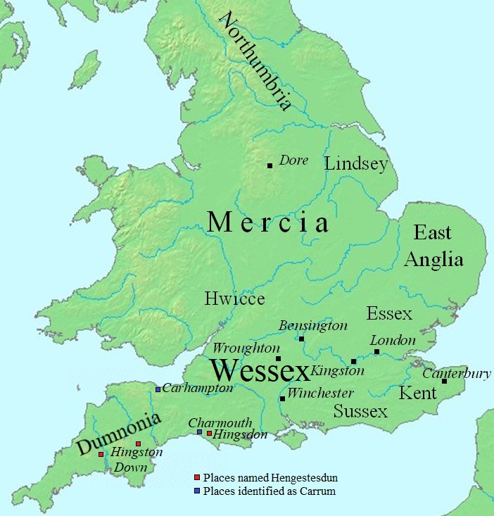
English: Map of England, showing places of interest to the Egbert of Wessex article.
The file was created using DMIS. On that site it is stated that "We do not claim copyright on the images, so you can use them for Wikipedia." en:Commons:category:Maps of England en:Commons:category:Wessex |
| Datum | 1 septimber 2007 (original upload date) |
| Boarne | Transferred from en.wikipedia to Commons. |
| Auteur | Mike Christie at Ingelsk Wikipedy |
| Oare ferzjes | File:Map Egbert of Wessex.svg |
Lisinsje
| This work has been released into the public domain by its author, Mike Christie at Ingelsk Wikipedy. This applies worldwide. In some countries this may not be legally possible; if so: Mike Christie grants anyone the right to use this work for any purpose, without any conditions, unless such conditions are required by law. |
Original upload log
The original description page was here. All following user names refer to en.wikipedia.
- 2007-09-09 17:57 Mike Christie 702×733×8 (87999 bytes)
- 2007-09-01 17:40 Mike Christie 602×628×8 (70407 bytes) == Summary == Map of southwestern England and south Wales, showing places visited by Asser. The file was created using [http://www.demis.nl/home/pages/home.htm DMIS]. On that site it is [http://support.demis.nl/forums/thread/1295.aspx stated] that "We d
Triemskiednis
Klik op in datum/tiid om it bestân te besjen sa't it op dat stuit wie.
| Datum/Tiid | Miniatuer | ôfmjittings | Meidogger | Opmerking | |
|---|---|---|---|---|---|
| lêste | 9 jul 2022, 15.01 | | 702 × 733 (136 KB) | Bodrugan | fixing a few of the place names on the map |
| 28 okt 2007, 19.40 |  | 702 × 733 (86 KB) | Ekki01 | {{Information |Description=Map of England, showing places of interest to the en:Egbert of Wessex article. The file was created using [http://www.demis.nl/home/pages/home.htm DMIS]. On that site it is [http://support.demis.nl/forums/thread/1295.aspx |
Bestânsgebrûk
De neikommende side brûkt dit bestân:
Globaal bestânsgebrûk
De neikommende oare wiki's brûke dit bestân:
- Gebrûk op br.wikipedia.org
- Gebrûk op ca.wikipedia.org
- Gebrûk op cs.wikipedia.org
- Gebrûk op de.wikipedia.org
- Gebrûk op el.wikipedia.org
- Gebrûk op en.wikipedia.org
- Gebrûk op eo.wikipedia.org
- Gebrûk op es.wikipedia.org
- Gebrûk op it.wikipedia.org
- Gebrûk op ja.wikipedia.org
- Gebrûk op lt.wikipedia.org
- Gebrûk op nl.wikipedia.org
- Gebrûk op no.wikipedia.org
- Gebrûk op pt.wikipedia.org
- Gebrûk op ru.wikipedia.org
- Gebrûk op simple.wikipedia.org
- Gebrûk op sv.wikipedia.org
- Gebrûk op th.wikipedia.org